


Old Map of "Italy: the Newest Empire" by Sundberg, 1939: WW2, Mussolin, Vs. Roman Empire
The price will update when you pick
different sizes and framing below

-
FREE delivery in 2 to 3 days
Free delivery in 2 to 3 days
Your map should be delivered in 2 to 3 working days with free delivery, worldwide.
Father's Day orders: Please use Next Day delivery at checkout. Free delivery is unlikely to arrive on time.
We make maps by hand locally in 23 countries. If you're buying a gift for someone in another country, we will make the map locally to them.
You will never pay import tax or customs duty.
Express delivery is available at checkout which can reduce the delivery time to 1-2 days.
Please note that personalised maps, and larger framed maps, can take longer to produce and deliver.
If you need your order to arrive by a certain date, contact me and we can discuss your options.
-
Certified sustainable +
we plant trees🌳
Sustainability & Tree Planting
Here at The Unique Maps Co., we have an unusually high affinity for paper. After all, without paper, there can be no maps!
That's why all of our paper, frames and packaging are from FSC certified sources.
But we don't stop there. We've partnered with Treeapp to plant trees around the world.
If you spend £50 or more, we'll plant a tree in your name.
We also cover the costs of offsetting the carbon emissions on all deliveries.
- Framing & free personalisation available
-
90 day money back guarantee
90 days to return and refund
Products can be returned within 90 days for a full refund, or exchange for another product.
For personalised or custom made items, we may offer you a non-expiring gift card, as we cannot resell personalised orders.
If you have any questions, get in touch. For more information, see our full returns & exchanges policy.
- Shop local! We're based in London
My maps are rare, museum-grade, restored old maps sourced from libraries, auction houses and private collections across the globe.
Message cadeau & finition personnalisée

Si vous souhaitez ajouter un message cadeau, ou une finition (puzzle, panneau en aluminium, etc.) qui n'est pas disponible ici, veuillez le demander dans la "note de commande" lors de votre passage à la caisse.
Chaque commande est fabriquée sur mesure, donc si vous avez besoin d'ajuster légèrement la taille, ou d'imprimer sur un matériau inhabituel, faites-le nous savoir. Nous avons réalisé des milliers de commandes personnalisées au fil des ans, donc il n'y a (presque) rien que nous ne puissions gérer.
Vous pouvez également nous contacter avant de passer votre commande, si vous le souhaitez !
- FREE 2-3 day worldwide delivery
- 90 day money back guarantee
- Handmade, museum-grade quality
- Bank grade payment security

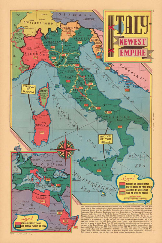
Step into a pivotal moment in world history with “Italy – Newest Empire,” a captivating pictorial map crafted by Edwin L. Sundberg and published on August 27, 1939. Created just days before the outbreak of World War II, this map offers a visually rich and thematically charged exploration of Italy’s imperial ambitions under Benito Mussolini’s fascist regime. Sundberg, renowned for his ability to translate complex geopolitical realities into accessible art, uses vibrant color and intricate illustration to capture both the grandeur and the tension of the era. This map is not only a testament to Italy’s aspirations but also a window into the anxieties and ambitions that shaped Europe on the eve of global conflict.
Intriguingly, an inset map compares Mussolini's new Italian empire to the old Roman Empire.
The map’s artistry is immediately apparent, blending cartographic precision with evocative pictorial elements. Italy sits at the center, surrounded by its Mediterranean neighbors and highlighted colonies in Africa—Libya, Eritrea, and Italian Somaliland—reflecting the country’s aggressive expansionist policies. Major cities such as Rome, Milan, Venice, and Naples are clearly marked, while the Mediterranean and Adriatic Seas are depicted as strategic theaters for Italian power. Sundberg’s use of military symbols, iconic landmarks, and imperial motifs brings to life the fervor of Italian nationalism and the propaganda of the time, making this map a unique artifact of both information and persuasion.
Historically, this map is invaluable for understanding the mindset and motivations that propelled Italy into the Second World War. It visually narrates the transformation of Italy from a regional power to an empire with overseas territories, illustrating routes of conquest and the integration of newly acquired lands like Ethiopia (then known as Abyssinia) into Italian East Africa. The map also places Italy in context with neighboring nations—France, Switzerland, Austria, and Yugoslavia—emphasizing the country’s centrality and the potential flashpoints that would soon ignite the continent. Each detail is a reminder of the precarious balance of power and the role of cartography in shaping public perception.
Beyond its political and military significance, “Italy – Newest Empire” is a masterclass in the art of thematic mapping. Sundberg’s decorative flourishes—classical motifs, banners, and vignettes—evoke the grandeur of ancient Rome while underscoring the modern ambitions of the fascist state. The map’s careful delineation of borders, strategic ports like Genoa and Taranto, and enclaves such as Vatican City and San Marino, reflect a nuanced understanding of Italy’s geography and its cultural complexity. The result is a map that is as informative as it is visually arresting, offering layers of meaning for historians, collectors, and enthusiasts alike.
Owning this map is akin to possessing a piece of living history—a document that encapsulates the hopes, fears, and realities of a world on the brink of war. Whether displayed as a centerpiece in a study or admired for its artistic merit, “Italy – Newest Empire” invites reflection on the forces that have shaped our modern world. It stands as both a cautionary tale and a celebration of the enduring power of maps to capture the spirit of an age.
Places on this map
- Rome
- Milan
- Venice
- Naples
- Florence
- Genoa
- Turin
- Trieste
- Taranto
- Palermo
- Cagliari (Sardinia)
- Addis Ababa (Ethiopia, Italian East Africa)
- Tripoli (Libya)
- Asmara (Eritrea)
- Mogadishu (Italian Somaliland)
- Rhodes (Dodecanese Islands)
- Vatican City
- San Marino
- Sicily
- Sardinia
Notable Features & Landmarks
- Italy prominently depicted at the center, emphasizing its central role in the map’s narrative
- Italian territories and colonies in Africa, such as Libya, Eritrea, and Italian Somaliland, are highlighted
- The island of Sicily and Sardinia are clearly marked
- Neighboring countries such as France, Switzerland, Austria, and Yugoslavia are shown for context
- The Mediterranean Sea is labeled and illustrated as a strategic area for Italian ambitions
- Major Italian cities such as Rome, Milan, Venice, Naples, and Florence are labeled
- Routes of expansion or conquest are indicated, possibly with arrows or lines
- Areas of recent or ongoing conflict, such as Ethiopia (Abyssinia), are depicted as part of the Italian empire
- Borders of Italian possessions are marked with bold lines or color differentiation
- The Alps and mountainous regions are illustrated to show natural boundaries
- The Suez Canal and its strategic importance are indicated
- Key battle sites or areas of recent military action are labeled
- Artistic embellishments such as decorative cartouches or banners with the map’s title
- The Adriatic Sea is labeled, emphasizing Italy’s eastern maritime interests
- The Dodecanese Islands (then under Italian control) are shown
- Italian East Africa, formed from conquered Ethiopian territory, is marked
- Illustrations of Italian aircraft or air routes may be present
- The map uses color to differentiate Italian lands from neighboring countries
- Notations or legends explaining symbols and colors used on the map
- The Vatican City and San Marino are shown as independent enclaves within Italy
- The map may include a timeline or dates of major events
- The map’s artistic border may feature classical Italian motifs
- Important ports such as Genoa, Trieste, and Taranto are labeled
- The map’s artistic style conveys a sense of dynamism and expansion
Historical and design context
- Name of the map: Italy - Newest Empire. August 27, 1939.
- Date created: August 27, 1939, shortly before the outbreak of World War II
- Mapmaker/publisher: Edwin L. Sundberg, a staff artist for the Sunday News
- The map is a pictorial and thematic map, rich in color and illustration, designed to be both informative and visually engaging
- Created at a time when Italy, under Benito Mussolini's fascist regime, was pursuing aggressive expansionist policies and imperial ambitions in Europe and Africa
- Highlights the extent of Italy’s territorial ambitions and recent conquests, reflecting Italian nationalism and imperialism on the eve of World War II
- Provides insight into Italy’s role and aspirations on the world stage, just days before the start of WWII
- Shows Italian colonies in Africa (such as Libya, Eritrea, and Italian Somaliland) and other territorial claims
- Serves as both an informative piece and a subtle commentary on the ambitions and propaganda of the Italian fascist regime
- Combines factual geographic information with artistic embellishments, typical of 1930s pictorial maps
- Captures a moment in pre-WWII history, illustrating the expansionist mindset that contributed to the outbreak of global conflict
- Edwin L. Sundberg was known for creating visually striking and informative maps and illustrations for newspapers, making complex international events accessible to the public
- Maps like this influenced how American readers understood the rapidly changing political landscape in Europe and Africa
- The map’s date coincides with the final days before WWII, highlighting Italy’s alliances and strategic interests
- Reflects widespread concerns about the stability of Europe and the ambitions of totalitarian states
- Today, the map is a valuable artifact for historians studying public opinion, media, and international relations in the late 1930s
Please double check the images to make sure that a specific town or place is shown on this map. You can also get in touch and ask us to check the map for you.
This map looks great at every size, but I always recommend going for a larger size if you have space. That way you can easily make out all of the details.
This map looks amazing at sizes all the way up to 70in (180cm). If you are looking for a larger map, please get in touch.
The model in the listing images is holding the 24x36in (60x90cm) version of this map.
The fifth listing image shows an example of my map personalisation service.
If you’re looking for something slightly different, check out my collection of the best old maps to see if something else catches your eye.
Please contact me to check if a certain location, landmark or feature is shown on this map.
This would make a wonderful birthday, Christmas, Father's Day, work leaving, anniversary or housewarming gift for someone from the areas covered by this map.
This map is available as a giclée print on acid free archival matte paper, or you can buy it framed. The frame is a nice, simple black frame that suits most aesthetics. Please get in touch if you'd like a different frame colour or material. My frames are glazed with super-clear museum-grade acrylic (perspex/acrylite), which is significantly less reflective than glass, safer, and will always arrive in perfect condition.
This map is also available as a float framed canvas, sometimes known as a shadow gap framed canvas or canvas floater. The map is printed on artist's cotton canvas and then stretched over a handmade box frame. We then "float" the canvas inside a wooden frame, which is available in a range of colours (black, dark brown, oak, antique gold and white). This is a wonderful way to present a map without glazing in front. See some examples of float framed canvas maps and explore the differences between my different finishes.
For something truly unique, this map is also available in "Unique 3D", our trademarked process that dramatically transforms the map so that it has a wonderful sense of depth. We combine the original map with detailed topography and elevation data, so that mountains and the terrain really "pop". For more info and examples of 3D maps, check my Unique 3D page.
Pour la plupart des commandes, le délai de livraison est d'environ 3 jours ouvrables. Les produits personnalisés et sur mesure prennent plus de temps, car je dois faire la personnalisation et vous l'envoyer pour approbation, ce qui prend généralement 1 ou 2 jours.
Veuillez noter que les grandes commandes encadrées prennent généralement plus de temps à réaliser et à livrer.
Si vous avez besoin que votre commande arrive à une date précise, veuillez me contacter avant de passer votre commande afin que nous puissions trouver le meilleur moyen de nous assurer que vous receviez votre commande à temps.
J'imprime et encadre des cartes et des œuvres d'art dans 23 pays à travers le monde. Cela signifie que votre commande sera réalisée localement, ce qui réduit le temps de livraison et garantit qu'elle ne sera pas endommagée pendant le transport. Vous ne paierez jamais de droits de douane ou d'importation, et nous mettrons moins de CO2 dans l'air.
Toutes mes cartes et impressions artistiques sont bien emballées et envoyées dans un tube robuste si non encadrées, ou entourées de mousse si encadrées.
J'essaie d'envoyer toutes les commandes dans les 1 ou 2 jours suivant la réception de votre commande, bien que certains produits (comme les masques, les mugs et les sacs fourre-tout) puissent prendre plus de temps à réaliser.
Si vous choisissez Livraison Express lors du paiement, nous donnerons la priorité à votre commande et l'enverrons par un service de messagerie de 1 jour (Fedex, DHL, UPS, Parcelforce).
La livraison le lendemain est également disponible dans certains pays (États-Unis, Royaume-Uni, Singapour, Émirats Arabes Unis), mais veuillez essayer de commander tôt dans la journée afin que nous puissions l'envoyer à temps.
Lisez mon guide complet sur la livraison et la production locale
Mon cadre standard est un cadre en bois dur noir de style galerie. Il est simple et a un aspect assez moderne. Mon cadre standard mesure environ 20 mm (0,8 po) de large.
J'utilise de l'acrylique super clair (perspex/acrylite) pour le verre du cadre. C'est plus léger et plus sûr que le verre - et cela a meilleur aspect, car la réflexivité est plus faible.
Six couleurs de cadre standard sont disponibles gratuitement (noir, marron foncé, gris foncé, chêne, blanc et or antique). Des encadrements et montages/matelassages personnalisés sont disponibles si vous recherchez autre chose.
La plupart des cartes, œuvres d'art et illustrations sont également disponibles sous forme de toile encadrée. Nous utilisons une toile en coton mate (non brillante), que nous tendons sur un cadre en bois de boîte provenant de sources durables, puis nous 'flottions' la pièce à l'intérieur d'un cadre en bois. Le résultat final est assez beau, et il n'y a pas de vitrage qui gêne.
Tous les cadres sont fournis "prêts à accrocher", avec soit une corde, soit des supports à l'arrière. Les très grands cadres auront des plaques de suspension lourdes et/ou une latte de montage. Si vous avez des questions, veuillez nous contacter.
Voir quelques exemples de mes cartes encadrées et de cartes en toile encadrées.
Alternativement, je peux également fournir de vieilles cartes et œuvres d'art sur toile, sur panneau en mousse, en coton et d'autres matériaux.
Si vous souhaitez encadrer votre carte ou œuvre d'art vous-même, veuillez lire d'abord mon guide des tailles.
Certaines de mes anciennes cartes sont maintenant disponibles en tant que toiles encadrées. Veuillez me contacter si vous souhaitez commander une taille qui n'est pas disponible dans ma boutique.
Les anciennes cartes en toile sont une alternative intéressante aux cartes encadrées de manière conventionnelle. Selon vos goûts personnels et la décoration de votre pièce, les cartes en toile peuvent "se démarquer" un peu plus qu'une carte encadrée.
Mes cartes sont des reproductions de cartes originales de très haute qualité.
Je recherche des cartes originales et rares auprès de bibliothèques, de maisons de ventes aux enchères et de collections privées du monde entier, je les restaure dans mon atelier de Londres, puis j'utilise des encres et des imprimantes giclées spécialisées pour créer de magnifiques cartes encore plus belles que l'originale.
Mes cartes sont imprimées sur du papier d’archives mat (non brillant) sans acide qui semble de très haute qualité et ressemble presque à une carte. En termes techniques, le grammage/épaisseur du papier est de 10 mil/200 g/m². C'est parfait pour l'encadrement.
J’imprime avec des encres pigmentaires Epson ultrachrome giclée UV résistantes à la décoloration – certaines des meilleures encres que vous puissiez trouver.
je peux aussi faire cartes sur toile, chiffon en coton et autres matériaux exotiques.
En savoir plus sur Unique Maps Co..
Personnalisation de la carte
Si vous recherchez le cadeau parfait pour un anniversaire ou une pendaison de crémaillère, je peux personnaliser votre carte pour la rendre vraiment unique. Par exemple, je peux ajouter un court message, mettre en évidence un lieu important ou ajouter les armoiries de votre famille.
Les options sont presque infinies. S'il vous plaît voir mon page de personnalisation de la carte pour quelques merveilleux exemples de ce qui est possible.
Pour commander une carte personnalisée, sélectionnez « personnaliser votre carte » avant de l'ajouter à votre panier.
Entrer en contact si vous recherchez des personnalisations et des personnalisations plus complexes.
Vieillissement de la carte
Au fil des ans, des clients m'ont demandé des centaines de fois s'ils pouvaient acheter une carte qui semble uniforme. plus vieux.
Eh bien, vous pouvez désormais le faire en sélectionnant Aged avant d'ajouter une carte à votre panier.
Toutes les photos de produits que vous voyez sur cette page montrent la carte dans sa forme originale. Voilà à quoi ressemble la carte aujourd'hui.
Si vous sélectionnez Vieilli, je vieillirai votre carte à la main, en utilisant un processus spécial et unique développé au cours d'années d'étude de cartes anciennes, de discussions avec des chercheurs pour comprendre la chimie du vieillissement du papier, et bien sûr... beaucoup de pratique !
Si vous n'êtes pas sûr, respectez la couleur originale de la carte. Si vous voulez quelque chose d'un peu plus sombre et plus vieux à la recherche, optez pour Aged.
Si vous n'êtes pas satisfait de votre commande pour une raison quelconque, contactez-moi pour un remboursement sans conditions.
Je suis très confiant que vous aimerez votre carte restaurée ou votre impression artistique. Je fais cela depuis 1984. Je suis un vendeur Etsy 5 étoiles. J'ai vendu des dizaines de milliers de cartes et d'impressions artistiques et j'ai plus de 4 000 avis réels 5 étoiles.
J'utilise un processus unique pour restaurer des cartes et des œuvres d'art qui est extrêmement chronophage et exigeant en main-d'œuvre. Trouver les cartes et illustrations originales peut prendre des mois. J'utilise une technologie à la pointe et extrêmement coûteuse pour les numériser et les restaurer. En conséquence, je garantis que mes cartes et impressions artistiques sont d'une qualité supérieure - c'est pourquoi je peux offrir un remboursement sans conditions.
Presque toutes mes cartes et impressions artistiques ont l'air incroyables en grandes tailles (200 cm, 6,5 pieds+) et je peux également les encadrer et vous les livrer via un transporteur spécial surdimensionné. Contactez-moi pour discuter de vos besoins spécifiques.


Or try searching for something!


