


Mappa antica di Washington e Oregon di Colton, 1859: Olympia, Vancouver, Salem, Portland, Walla Walla
L’offerta del Collezionista
Scegli due opere idonee e ricevi il 20% di sconto su entrambe. Scegline tre e quella al prezzo più basso è in omaggio, con un risparmio massimo del 33%.
Abbina liberamente mappe standard idonee e stampe d’arte fine art. Non è richiesto alcun codice; l’offerta viene applicata automaticamente al checkout.
Sono incluse le configurazioni standard su ordinazione. Sono esclusi formati su misura, design personalizzati e lavori su commissione.
Hai bisogno di consegne a indirizzi diversi? Contattaci prima di effettuare l’ordine.L’offerta del Collezionista
Scegli due opere idonee e ricevi il 20% di sconto su entrambe. Scegline tre e quella al prezzo più basso è in omaggio, con un risparmio massimo del 33%.
Abbina liberamente mappe standard idonee e stampe d’arte fine art. Non è richiesto alcun codice; l’offerta viene applicata automaticamente al checkout.
Sono incluse le configurazioni standard su ordinazione. Sono esclusi formati su misura, design personalizzati e lavori su commissione.
Hai bisogno di consegne a indirizzi diversi? Contattaci prima di effettuare l’ordine. Progettato a Londra Prodotto in the UK
Progettato a Londra • Prodotto in the UK
Progettato a Londra Prodotto in the UK
Progettato a Londra • Prodotto in the UK

Restaurata dalla mappa originale del 1859 e stampata in qualità museale. Leggi la storia dietro questa mappa
Choose your size
Choose your finish


(Maggiori informazioni)
Gift message & custom finish

If you want to add a gift message, or a finish (jigsaw, aluminium board, etc.) that is not available here, please request it in the "order note" when you check out.
Every order is custom made, so if you need the size adjusted slightly, or printed on an unusual material, just let us know. We've done thousands of custom orders over the years, so there's (almost) nothing we can't manage.
You can also contact us before you order, if you prefer!

- Prodotto localmente. Consegna sicura
- Nessun dazio o costo nascosto
- Serve aiuto? Chiamaci o messaggio su WhatsApp
Own a piece of history
8,000+ five-star reviews


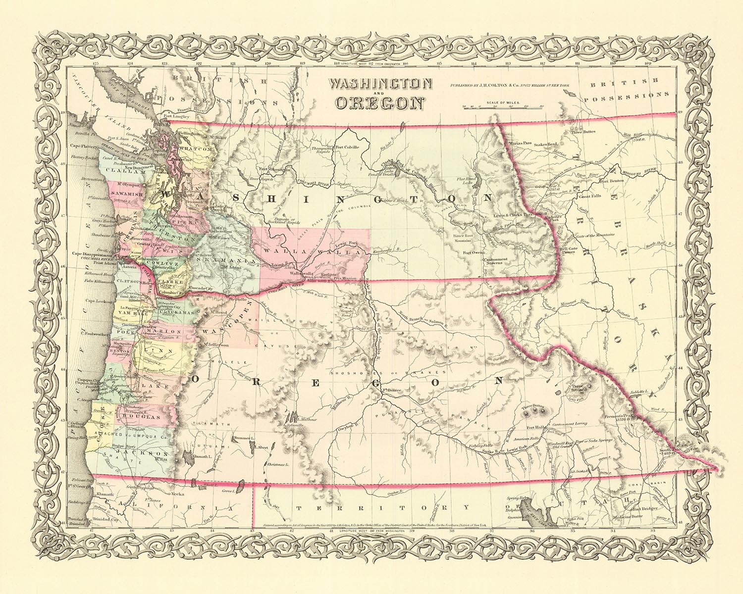
Immergiti nella ricca storia degli Stati Uniti con questa squisita mappa antica di Washington e Oregon del 1859, realizzata dal rinomato cartografo...
Continua a leggereImmergiti nella ricca storia degli Stati Uniti con questa squisita mappa antica di Washington e Oregon del 1859, realizzata dal rinomato cartografo J. H. Colton. Conosciuto per la sua meticolosa attenzione ai dettagli e l'eccezionale qualità del suo lavoro, Colton è ampiamente riconosciuto come uno dei migliori cartografi americani della sua epoca. Questa mappa è una testimonianza della sua abilità e dedizione, offrendo uno sguardo affascinante nel passato.
Questa mappa proviene da un'epoca in cui gli Stati Uniti erano ancora nella loro infanzia, con molti insediamenti ancora da fondare. Fornisce un'istantanea di un momento della storia in cui il West era ancora per lo più territorio inesplorato, in attesa di essere scoperto e colonizzato. La storia della regione è incisa in ogni linea e segno su questa mappa, raccontando una storia di un'epoca in cui il futuro di questi stati era ancora da scrivere.
Negli ultimi 150 anni, molti nomi e confini sono inevitabilmente cambiati, aggiungendo un ulteriore strato di intrigo a questo artefatto storico. Gli insediamenti di Olympia, Vancouver, Salem, Portland e Walla Walla, che erano tra i più notevoli dell'epoca, sono tutti in evidenza. Ognuno di questi insediamenti ha la propria storia unica e significato, contribuendo al ricco arazzo del passato della regione.
Che tu sia un appassionato di storia, un amante della cartografia o semplicemente qualcuno che apprezza la bellezza e l'artigianato delle vecchie mappe, questo pezzo è sicuro di catturare e ispirare. Non è solo una mappa—è un viaggio nel passato, un'opportunità per esplorare la storia di Washington e Oregon com'era nel 1859, attraverso gli occhi di uno dei cartografi più rispettati d'America. Questo è più di un semplice acquisto—è un investimento in un pezzo di storia, un argomento di conversazione e un'aggiunta straordinaria a qualsiasi collezione. Non perdere l'opportunità di possedere questo straordinario pezzo di storia americana.
Insediamenti in Washington (1859)
- Olympia (1850): Conosciuta come la fine dell'Oregon Trail, Olympia divenne la capitale del Territorio di Washington nel 1853.
- Vancouver (1825): Originariamente Fort Vancouver, era un importante avamposto commerciale di pellicce per la Hudson's Bay Company.
- Walla Walla (1818): Fondato come avamposto commerciale di pellicce dalla Hudson's Bay Company, era conosciuto come Fort Nez Perces.
- Steilacoom (1851): La città incorporata più antica di Washington, era conosciuta per la sua grande presenza militare.
- Seattle (1851): Prende il nome dal Capo Sealth, Seattle era un importante porto per le industrie del legname e del carbone.
- Tacoma (1852): Conosciuta come la "Città del Destino", era il termine occidentale della Northern Pacific Railroad.
- Spokane (1810): Conosciuta come Spokane House, è stata uno dei primi insediamenti europei in Washington.
- Bellingham (1852): Originariamente conosciuta come Whatcom, era un luogo chiave durante la Fraser Canyon Gold Rush.
- Port Townsend (1851): Conosciuta come la "Città dei Sogni", era un vivace porto marittimo a metà del XIX secolo.
- Everett (1852): Conosciuta per le sue risorse naturali, era un centro per le industrie del legname e dell'estrazione mineraria.
Insediamenti in Oregon (1859)
- Salem (1842): La capitale dell'Oregon, era un luogo chiave per i primi missionari metodisti.
- Portland (1845): Conosciuta come "Stumptown" a causa della sua rapida crescita, era un importante porto nel Pacifico nord-occidentale.
- Astoria (1811): Il più antico insediamento americano a ovest delle Montagne Rocciose, era un importante avamposto commerciale di pellicce.
- Eugene (1846): Conosciuta per le sue terre agricole fertili, era una meta popolare per i coloni lungo il sentiero dell'Oregon.
- Oregon City (1829): La capitale originale del Territorio dell'Oregon, era la fine del sentiero dell'Oregon.
- Bend (1858): Conosciuta per la sua industria del legname, era un luogo chiave per i pionieri.
- Medford (1852): Conosciuta per i suoi frutteti e vigneti, era un luogo chiave per la corsa all'oro in California.
- Corvallis (1845): Sede della Oregon State University, era un centro di istruzione e cultura.
- Roseburg (1851): Conosciuta per la sua industria del legname, era un luogo chiave per i pionieri.
- Pendleton (1851): Conosciuta per i suoi mulini di lana, era un luogo chiave per i pionieri.
Tribù Native
- Chinook: Occupava la regione del fiume Columbia inferiore.
- Nez Perce: Abitava la regione del plateau di Washington.
- Yakama: Occupava la regione centro-meridionale di Washington.
- Umatilla: Viveva nella regione nord-orientale dell'Oregon.
- Kalapuya: Abitava la regione della Willamette Valley in Oregon.
Atrazioni Naturali
- Fiume Columbia: Il fiume più grande del Pacifico nord-occidentale.
- Monte Rainier: Un vulcano attivo e la montagna più alta di Washington.
- Crater Lake: Il lago più profondo degli Stati Uniti, situato in Oregon.
- Multnomah Falls: Una cascata situata nel Columbia River Gorge.
- Hells Canyon: La gola fluviale più profonda del Nord America.
Eventi Storici
- Sentiero dell'Oregon (1811-1850): Oltre 400.000 coloni migrarono verso ovest su questo sentiero durante la metà del XIX secolo.
- Massacro di Whitman (1847): Un evento tragico in cui gli indiani Cayuse uccisero Marcus e Narcissa Whitman e altre 12 persone.
- Trattato del 1855: Diversi trattati firmati dal governo degli Stati Uniti e dalle tribù in Washington e Oregon, che portarono a una significativa perdita di terre per le tribù.
Si prega di controllare attentamente le immagini per assicurarsi che una specifica città o luogo sia mostrato su questa mappa. Puoi anche contattarci e chiedere di controllare la mappa per te.
Questa mappa appare fantastica in tutte le dimensioni: 12x16in (30.5x41cm), 16x20in (40.5x51cm), 18x24in (45.5x61cm), 24x30in (61x76cm), 32x40in (81.5x102cm), 40x50in (102x127cm), 48x60in (122x153cm) e 56x70in (142x178cm), ma appare ancora meglio quando stampata in grande.
Posso creare stampe belle e grandi di questa mappa fino a 70in (178cm). Ti preghiamo di contattarci se stai cercando opzioni di stampa più grandi, personalizzate o diverse.
Il modello nelle immagini dell'elenco tiene la versione 16x20in (40.5x51cm) di questa mappa.
L'immagine dell'elenco numero cinque mostra un esempio del mio servizio di personalizzazione della mappa.
Se stai cercando qualcosa di leggermente diverso, dai un'occhiata alla mia collezione di mappe degli Stati Uniti e del Nord America.
Per favore contattami per verificare se una certa posizione, punto di riferimento o caratteristica è mostrata su questa mappa.
Questo sarebbe un meraviglioso regalo per un compleanno, Natale, Festa del Papà, pensionamento, anniversario o inaugurazione della casa per qualcuno delle aree coperte da questa mappa.
Questa mappa è disponibile come stampa giclée su carta opaca archivistica priva di acidi, oppure puoi acquistarla incorniciata. La cornice è una bella e semplice cornice nera che si adatta alla maggior parte delle estetiche. Per favore, contattami se desideri un colore o materiale diverso per la cornice. Le mie cornici sono vetriate con acrilico di grado museale super chiaro (perspex/acrylite), che è significativamente meno riflettente del vetro, più sicuro e arriverà sempre in perfette condizioni.
This map is also available as a float framed canvas, sometimes known as a shadow gap framed canvas or canvas floater. The map is printed on artist's cotton canvas and then stretched over a handmade box frame. We then "float" the canvas inside a wooden frame, which is available in a range of colours (black, dark brown, oak, antique gold and white). This is a wonderful way to present a map without glazing in front. See some examples of float framed canvas maps and explore the differences between my different finishes.
For something truly unique, this map is also available in "Unique 3D", our trademarked process that dramatically transforms the map so that it has a wonderful sense of depth. We combine the original map with detailed topography and elevation data, so that mountains and the terrain really "pop". For more info and examples of 3D maps, check my Unique 3D page.
Immergiti nella ricca storia degli Stati Uniti con questa squisita mappa antica di Washington e Oregon del 1859, realizzata dal rinomato cartografo J. H. Colton. Conosciuto per la sua meticolosa attenzione ai dettagli e l'eccezionale qualità del suo lavoro, Colton è ampiamente riconosciuto come uno dei migliori cartografi americani della sua epoca. Questa mappa è una testimonianza della sua abilità e dedizione, offrendo uno sguardo affascinante nel passato.
Questa mappa proviene da un'epoca in cui gli Stati Uniti erano ancora nella loro infanzia, con molti insediamenti ancora da fondare. Fornisce un'istantanea di un momento della storia in cui il West era ancora per lo più territorio inesplorato, in attesa di essere scoperto e colonizzato. La storia della regione è incisa in ogni linea e segno su questa mappa, raccontando una storia di un'epoca in cui il futuro di questi stati era ancora da scrivere.
Negli ultimi 150 anni, molti nomi e confini sono inevitabilmente cambiati, aggiungendo un ulteriore strato di intrigo a questo artefatto storico. Gli insediamenti di Olympia, Vancouver, Salem, Portland e Walla Walla, che erano tra i più notevoli dell'epoca, sono tutti in evidenza. Ognuno di questi insediamenti ha la propria storia unica e significato, contribuendo al ricco arazzo del passato della regione.
Che tu sia un appassionato di storia, un amante della cartografia o semplicemente qualcuno che apprezza la bellezza e l'artigianato delle vecchie mappe, questo pezzo è sicuro di catturare e ispirare. Non è solo una mappa—è un viaggio nel passato, un'opportunità per esplorare la storia di Washington e Oregon com'era nel 1859, attraverso gli occhi di uno dei cartografi più rispettati d'America. Questo è più di un semplice acquisto—è un investimento in un pezzo di storia, un argomento di conversazione e un'aggiunta straordinaria a qualsiasi collezione. Non perdere l'opportunità di possedere questo straordinario pezzo di storia americana.
Insediamenti in Washington (1859)
- Olympia (1850): Conosciuta come la fine dell'Oregon Trail, Olympia divenne la capitale del Territorio di Washington nel 1853.
- Vancouver (1825): Originariamente Fort Vancouver, era un importante avamposto commerciale di pellicce per la Hudson's Bay Company.
- Walla Walla (1818): Fondato come avamposto commerciale di pellicce dalla Hudson's Bay Company, era conosciuto come Fort Nez Perces.
- Steilacoom (1851): La città incorporata più antica di Washington, era conosciuta per la sua grande presenza militare.
- Seattle (1851): Prende il nome dal Capo Sealth, Seattle era un importante porto per le industrie del legname e del carbone.
- Tacoma (1852): Conosciuta come la "Città del Destino", era il termine occidentale della Northern Pacific Railroad.
- Spokane (1810): Conosciuta come Spokane House, è stata uno dei primi insediamenti europei in Washington.
- Bellingham (1852): Originariamente conosciuta come Whatcom, era un luogo chiave durante la Fraser Canyon Gold Rush.
- Port Townsend (1851): Conosciuta come la "Città dei Sogni", era un vivace porto marittimo a metà del XIX secolo.
- Everett (1852): Conosciuta per le sue risorse naturali, era un centro per le industrie del legname e dell'estrazione mineraria.
Insediamenti in Oregon (1859)
- Salem (1842): La capitale dell'Oregon, era un luogo chiave per i primi missionari metodisti.
- Portland (1845): Conosciuta come "Stumptown" a causa della sua rapida crescita, era un importante porto nel Pacifico nord-occidentale.
- Astoria (1811): Il più antico insediamento americano a ovest delle Montagne Rocciose, era un importante avamposto commerciale di pellicce.
- Eugene (1846): Conosciuta per le sue terre agricole fertili, era una meta popolare per i coloni lungo il sentiero dell'Oregon.
- Oregon City (1829): La capitale originale del Territorio dell'Oregon, era la fine del sentiero dell'Oregon.
- Bend (1858): Conosciuta per la sua industria del legname, era un luogo chiave per i pionieri.
- Medford (1852): Conosciuta per i suoi frutteti e vigneti, era un luogo chiave per la corsa all'oro in California.
- Corvallis (1845): Sede della Oregon State University, era un centro di istruzione e cultura.
- Roseburg (1851): Conosciuta per la sua industria del legname, era un luogo chiave per i pionieri.
- Pendleton (1851): Conosciuta per i suoi mulini di lana, era un luogo chiave per i pionieri.
Tribù Native
- Chinook: Occupava la regione del fiume Columbia inferiore.
- Nez Perce: Abitava la regione del plateau di Washington.
- Yakama: Occupava la regione centro-meridionale di Washington.
- Umatilla: Viveva nella regione nord-orientale dell'Oregon.
- Kalapuya: Abitava la regione della Willamette Valley in Oregon.
Atrazioni Naturali
- Fiume Columbia: Il fiume più grande del Pacifico nord-occidentale.
- Monte Rainier: Un vulcano attivo e la montagna più alta di Washington.
- Crater Lake: Il lago più profondo degli Stati Uniti, situato in Oregon.
- Multnomah Falls: Una cascata situata nel Columbia River Gorge.
- Hells Canyon: La gola fluviale più profonda del Nord America.
Eventi Storici
- Sentiero dell'Oregon (1811-1850): Oltre 400.000 coloni migrarono verso ovest su questo sentiero durante la metà del XIX secolo.
- Massacro di Whitman (1847): Un evento tragico in cui gli indiani Cayuse uccisero Marcus e Narcissa Whitman e altre 12 persone.
- Trattato del 1855: Diversi trattati firmati dal governo degli Stati Uniti e dalle tribù in Washington e Oregon, che portarono a una significativa perdita di terre per le tribù.
Si prega di controllare attentamente le immagini per assicurarsi che una specifica città o luogo sia mostrato su questa mappa. Puoi anche contattarci e chiedere di controllare la mappa per te.
Questa mappa appare fantastica in tutte le dimensioni: 12x16in (30.5x41cm), 16x20in (40.5x51cm), 18x24in (45.5x61cm), 24x30in (61x76cm), 32x40in (81.5x102cm), 40x50in (102x127cm), 48x60in (122x153cm) e 56x70in (142x178cm), ma appare ancora meglio quando stampata in grande.
Posso creare stampe belle e grandi di questa mappa fino a 70in (178cm). Ti preghiamo di contattarci se stai cercando opzioni di stampa più grandi, personalizzate o diverse.
Il modello nelle immagini dell'elenco tiene la versione 16x20in (40.5x51cm) di questa mappa.
L'immagine dell'elenco numero cinque mostra un esempio del mio servizio di personalizzazione della mappa.
Se stai cercando qualcosa di leggermente diverso, dai un'occhiata alla mia collezione di mappe degli Stati Uniti e del Nord America.
Per favore contattami per verificare se una certa posizione, punto di riferimento o caratteristica è mostrata su questa mappa.
Questo sarebbe un meraviglioso regalo per un compleanno, Natale, Festa del Papà, pensionamento, anniversario o inaugurazione della casa per qualcuno delle aree coperte da questa mappa.
Questa mappa è disponibile come stampa giclée su carta opaca archivistica priva di acidi, oppure puoi acquistarla incorniciata. La cornice è una bella e semplice cornice nera che si adatta alla maggior parte delle estetiche. Per favore, contattami se desideri un colore o materiale diverso per la cornice. Le mie cornici sono vetriate con acrilico di grado museale super chiaro (perspex/acrylite), che è significativamente meno riflettente del vetro, più sicuro e arriverà sempre in perfette condizioni.
This map is also available as a float framed canvas, sometimes known as a shadow gap framed canvas or canvas floater. The map is printed on artist's cotton canvas and then stretched over a handmade box frame. We then "float" the canvas inside a wooden frame, which is available in a range of colours (black, dark brown, oak, antique gold and white). This is a wonderful way to present a map without glazing in front. See some examples of float framed canvas maps and explore the differences between my different finishes.
For something truly unique, this map is also available in "Unique 3D", our trademarked process that dramatically transforms the map so that it has a wonderful sense of depth. We combine the original map with detailed topography and elevation data, so that mountains and the terrain really "pop". For more info and examples of 3D maps, check my Unique 3D page.
Many of our maps and art prints are chosen as thoughtful gifts for homes, offices, studies and meaningful places.
Choose a framed option for the easiest ready-to-hang gift, or choose an unframed print if the recipient may prefer to select their own frame.
We make orders locally in 23 countries around the world, so gifts can often be produced close to the recipient. This helps them arrive faster, travel more safely, and avoid customs or import duty surprises.
- We can deliver directly to the recipient
- Framed pieces arrive ready to hang
- Unframed prints are carefully packed in a strong protective tube
- Almost every order is made locally, for faster, safer gifting
- 90-day returns give the recipient time to decide
If you are not sure what to choose, please contact us. We can help you pick the right map, size, finish or delivery option.
Most orders are made locally and delivered in around 2–3 working days, depending on the product, size and destination.
We print and frame maps and artwork in 23 countries around the world, so your order is usually made close to you or your recipient. That means faster delivery, less time in transit, and no customs or import duty surprises.
Personalised and customised pieces usually take an extra 1–2 working days, because we prepare your design and send it to you for approval before printing.
Very large framed orders can take a little longer, as they need extra care in production and delivery.
Every order is carefully packaged: unframed prints are sent in a strong protective tube, while framed pieces are securely packed with protective materials around the frame.
If you need your order by a particular date, please contact us before ordering. We’ll check the best production route and delivery option for your location.
Express delivery is available at checkout for most countries. Next-day delivery is available in the UK, US, Singapore and the UAE.
Your order is covered by our 90-day returns policy and 10-year guarantee.
Our standard frame is a gallery-style black ash hardwood frame, with a simple, modern look. It is approximately 20mm (0.8in) wide. You can also view some lovely customer photos of framed maps and art.
We use super-clear acrylic glazing, also known as Perspex or Acrylite, instead of traditional glass. It is lighter, safer, and has lower reflectivity, giving the artwork a clearer, cleaner appearance.
Six standard frame colours are available at no extra cost: black, dark brown, dark grey, oak, white, and antique gold. Custom framing and mounting/matting is also available for customers looking for something more specific.
Most maps, art prints, and illustrations are also available as a framed canvas. We use matte cotton canvas, stretch it over a sustainably sourced wooden box frame, and then float the piece within a wooden outer frame. The finished result is beautifully presented, with no glazing between you and the artwork.
All frames are supplied ready to hang, with either string or brackets fitted to the back. Very large frames will include heavy-duty hanging plates and/or a mounting baton. If you have any questions, please get in touch.
We can also supply old maps and artwork on canvas, foam board, cotton rag, and other materials.
If you would prefer to frame your map or artwork yourself, please read our size guide before ordering.
My maps are extremely high quality reproductions of original maps.
I source original, rare maps from libraries, auction houses and private collections around the world, restore them at my London workshop, and then use specialist giclée inks and printers to create beautiful maps that look even better than the original.
My maps are printed on acid-free archival matte (not glossy) paper that feels very high quality and almost like card. In technical terms the paper weight/thickness is 10mil/200gsm. It's perfect for framing.
I print with Epson ultrachrome giclée UV fade resistant pigment inks - some of the best inks you can find.
I can also make maps on canvas, cotton rag and other exotic materials.
Learn more about The Unique Maps Co.
Map personalisation
If you're looking for the perfect anniversary or housewarming gift, I can personalise your map to make it truly unique. For example, I can add a short message, or highlight an important location, or add your family's coat of arms.
The options are almost infinite. Please see my map personalisation page for some wonderful examples of what's possible.
To order a personalised map, select "personalise your map" before adding it to your basket.
Get in touch if you're looking for more complex customisations and personalisations.
Map ageing
I have been asked hundreds of times over the years by customers if they could buy a map that looks even older.
Well, now you can, by selecting Aged before you add a map to your basket.
All the product photos you see on this page show the map in its Original form. This is what the map looks like today.
If you select Aged, I will age your map by hand, using a special and unique process developed through years of studying old maps, talking to researchers to understand the chemistry of aging paper, and of course... lots of practice!
If you're unsure, stick to the Original colour of the map. If you want something a bit darker and older looking, go for Aged.
Se non sei soddisfatto del tuo ordine per qualsiasi motivo, contattami per un rimborso senza problemi. Si prega di consultare la nostra politica di reso e rimborso per ulteriori informazioni.
Sono molto sicuro che ti piacerà la tua mappa restaurata o la stampa d'arte. Lo faccio dal 1984. Sono un venditore Etsy a 5 stelle. Ho venduto decine di migliaia di mappe e stampe d'arte e ho oltre 5.000 recensioni reali a 5 stelle.
Utilizzo un processo unico per restaurare mappe e opere d'arte che richiede molto tempo e lavoro. Trovare le mappe e le illustrazioni originali può richiedere mesi. Utilizzo tecnologia all'avanguardia e incredibilmente costosa per scannerizzare e restaurarle. Di conseguenza, garantisco che le mie mappe e stampe d'arte siano superiori alle altre - ecco perché posso offrire un rimborso senza problemi.
Quasi tutte le mie mappe e stampe d'arte sembrano fantastiche a grandi dimensioni (200 cm, 6,5 piedi+) e posso anche incorniciarle e consegnarle a te, tramite un corriere speciale per oggetti di grandi dimensioni. Contattami per discutere delle tue esigenze specifiche.
Or try searching for something!


