


Mappa di Atlantide dopo la catastrofe 800.000 anni fa di Scott-Elliot, 1904
20% di sconto su 2 — 33% di sconto su 3
Aggiungi qualsiasi due articoli idonei al tuo carrello per ricevere 20% di sconto. Aggiungi un terzo e sarà gratuito (equivalente a 33% di sconto quando acquisti tre).
Nessun codice necessario — l'offerta si applica automaticamente al checkout.
Valido su tutte le mappe standard e le stampe d'arte fine. Puoi mescolare e abbinare qualsiasi design.
Se desideri spedire articoli a più indirizzi, ti preghiamo di contattarci prima di effettuare il tuo ordine.
Le commissioni personalizzate e su misura sono escluse.
Contattaci se hai domande
-
![]() Made to order locally in the UK
Made to order locally in the UK

-
Free delivery 2-3 days ⓘ
Free delivery in 2-3 days
Your map should be delivered in 2-3 working days with free delivery, worldwide.
We make maps by hand locally in 23 countries. If you're buying a gift for someone in another country, we will make the map locally to them.
You will never pay import tax or customs duty.
Express delivery is available at checkout which can reduce the delivery time to 1-2 days.
Please note that personalised maps, and larger framed maps, can take longer to produce and deliver.
If you need your order to arrive by a certain date, contact me and we can discuss your options.
-
Complimentary gifting & design advice
ⓘ
Complimentary gifting & design advice
Available almost 24/7 on WhatsApp and email — we usually reply within minutes. We can help you:
- Choose a perfectly personalised gift
- Send a digital gift preview to the recipient
- Pick the ideal size for your wall
- Select the right finish and frame
Quick, friendly advice so you can order with confidence.
For last minute gifts, consider buying a digital gift card. We have over 5,000 maps and art prints to choose from.
-
90-day returns & 5-year guarantee
ⓘ
90 giorni per restituire e ricevere un rimborso
I prodotti possono essere restituiti entro 90 giorni per un rimborso completo, o cambio con un altro prodotto.
Per articoli personalizzati e su misura, potremmo offrirti un credito in negozio o una carta regalo non scadente, poiché non possiamo rivendere ordini personalizzati.
Se hai domande, contattaci. Per ulteriori informazioni, consulta la nostra politica di restituzione e cambio.

This is a museum-grade archival print from the original 1904 map — restored in our workshop and made to order on 220gsm archival matte paper or 400gsm artist's cotton canvas with pigment inks.
Beautifully framed and ready to hang, with complimentary personalisation available.
Choose your size
Choose your frame


Gift message & custom finish

If you want to add a gift message, or a finish (jigsaw, aluminium board, etc.) that is not available here, please request it in the "order note" when you check out.
Every order is custom made, so if you need the size adjusted slightly, or printed on an unusual material, just let us know. We've done thousands of custom orders over the years, so there's (almost) nothing we can't manage.
You can also contact us before you order, if you prefer!

- Handmade locally. No import duty or tax
- FREE worldwide delivery
- 90-day returns & 5-year product guarantee
- Questions? WhatsApp me any time
Own a piece of history
7,000+ 5 star reviews


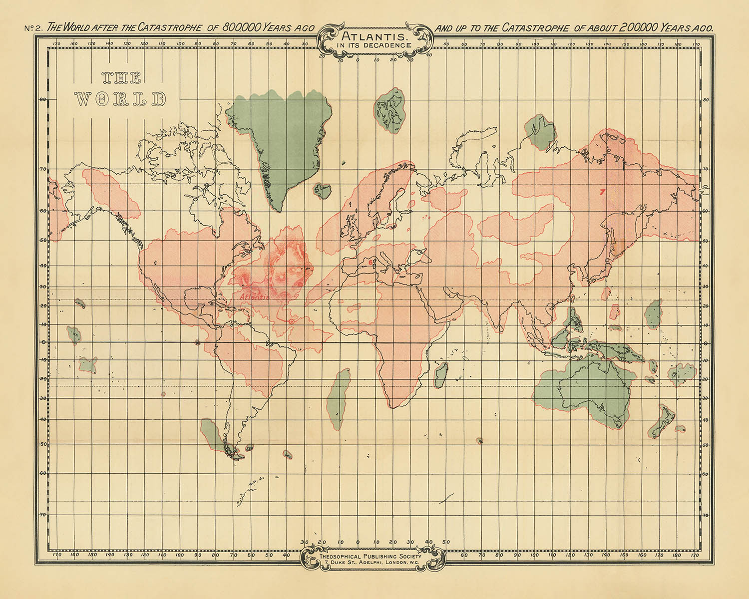
Entra nel mondo mistico delle antiche civiltà con "Atlantis in its Decadence No. 2," una mappa affascinante realizzata da William Scott-Elliot nel 1904. Questa mappa offre uno sguardo affascinante sulla geografia speculativa di Atlantide e Lemuria, due continenti leggendari che hanno intrigato esploratori e studiosi per secoli. Scott-Elliot, una figura influente nel movimento teosofico, combina le sue intuizioni antropologiche con gli insegnamenti esoterici dell'epoca per creare una narrativa visiva unica. La mappa ti invita a esplorare un mondo rimodellato da eventi catastrofici, dove i confini tra storia e mito si confondono in uno.
Il design della mappa riflette la fascinazione dell'inizio del XX secolo per il misticismo e le storie spirituali alternative. Mostra la ricostruzione immaginativa della geografia terrestre dopo due eventi catastrofici che si ritiene siano avvenuti 800.000 e 200.000 anni fa. La collaborazione di Scott-Elliot con Charles Webster Leadbeater, la cui "chiaroveggenza astrale" ha informato gran parte di questo lavoro, è evidente nella dettagliata rappresentazione dei presunti spostamenti delle masse terrestri. Le intricate linee della griglia e gli abbellimenti artistici della mappa evidenziano la fusione tra indagine scientifica e visione spirituale che ha caratterizzato l'approccio della Società Teosofica.
Al centro di questa mappa c'è la rappresentazione di Atlantide, un continente che si dice sia esistito nell'Oceano Atlantico. Questa terra leggendaria, casa di civiltà avanzate come i Toltechi, è rappresentata con precisione speculativa, offrendo una finestra sulle narrazioni teosofiche dell'evoluzione umana. Accanto ad Atlantide, la mappa presenta Lemuria, un continente che si crede fosse situato nell'Oceano Pacifico. Queste regioni sono illustrate con aree ombreggiate, suggerendo la loro trasformazione nel corso dei millenni e il loro ruolo nello sviluppo delle antiche razze radice.
Il significato storico di questa mappa risiede nella sua riflessione sulle indagini culturali e spirituali dell'inizio del XX secolo. Essa rappresenta una testimonianza della duratura fascinazione umana per le civiltà perdute e i misteri del nostro passato antico. Come un artefatto del movimento teosofico, incapsula l'intersezione tra misticismo, pseudo-storia e la ricerca di comprensione spirituale. Per studiosi e appassionati di storia speculativa e filosofia esoterica, questa mappa offre preziose intuizioni sulle correnti intellettuali dell'epoca.
Possedere questa mappa è come possedere un pezzo di storia che colma il divario tra mito e realtà. Ti invita a riflettere sulle possibilità di mondi dimenticati e sulle narrazioni che hanno plasmato la coscienza umana. Che tu sia un collezionista di mappe storiche o un cercatore di saggezza spirituale, "Atlantis in its Decadence No. 2" è un'aggiunta notevole a qualsiasi collezione, offrendo sia bellezza estetica che un profondo contesto storico.
Luoghi su questa mappa
- Atlantide (fittizia)
- Lemuria (fittizia)
- Masse terrestri speculative negli Oceani Atlantico e Pacifico
- Continenti e regioni immaginarie sulla mappa del mondo
- Aree ombreggiate che indicano cambiamenti geografici
Caratteristiche e punti di riferimento notevoli
- Rappresentazione speculativa di Atlantide nell'Oceano Atlantico
- Regioni e continenti immaginari come Lemuria nell'Oceano Pacifico
- Aree ombreggiate che rappresentano cambiamenti nelle masse terrestri dopo il catastrofismo
- Linee della griglia che suggeriscono un approccio scientifico alla geografia speculativa
- Etichette che indicano le presunte posizioni delle civiltà antiche
- Abbellimenti artistici nel titolo e nel design del bordo della mappa
Contesto storico e di design
- Creato da William Scott-Elliot nel 1904
- Pubblicato dalla Theosophical Publishing Society
- Riflette il fascino per il misticismo e le credenze esoteriche all'inizio del XX secolo
- Ricostruzione immaginaria della geografia terrestre dopo eventi catastrofici
- Influenzato dagli insegnamenti teosofici e dalla "clairvoyance astrale" di Charles Webster Leadbeater
- Combina indagine scientifica con visione spirituale, caratteristica della Società Teosofica
Si prega di controllare attentamente le immagini per assicurarsi che una specifica città o luogo sia mostrato su questa mappa. Puoi anche contattarci e chiedere di controllare la mappa per te.
Questa mappa appare fantastica in ogni dimensione, ma consiglio sempre di optare per una dimensione più grande se hai spazio. In questo modo puoi facilmente distinguere tutti i dettagli.
Questa mappa appare incredibile in dimensioni fino a 70in (180cm). Se stai cercando una mappa più grande, per favore contattaci.
Il modello nelle immagini dell'elenco tiene la versione 16x20in (40x50cm) di questa mappa.
La quinta immagine dell'elenco mostra un esempio del mio servizio di personalizzazione delle mappe.
Se stai cercando qualcosa di leggermente diverso, dai un'occhiata alla mia collezione delle migliori mappe antiche per vedere se qualcosa cattura la tua attenzione.
Si prega di contattarmi per verificare se una certa posizione, punto di riferimento o caratteristica è mostrata su questa mappa.
Questa sarebbe un'ottima idea regalo per un compleanno, Natale, Festa del Papà, partenza dal lavoro, anniversario o inaugurazione della casa per qualcuno delle aree coperte da questa mappa.
Questa mappa è disponibile come stampa giclée su carta opaca archiviata senza acidi, oppure puoi acquistarla incorniciata. La cornice è una semplice cornice nera che si adatta alla maggior parte degli stili. Si prega di contattare se desideri un colore o un materiale diverso per la cornice. Le mie cornici sono dotate di un acrilico (perspex/acrylite) di grado museale super chiaro, che è significativamente meno riflettente del vetro, più sicuro e arriverà sempre in condizioni perfette.
This map is also available as a float framed canvas, sometimes known as a shadow gap framed canvas or canvas floater. The map is printed on artist's cotton canvas and then stretched over a handmade box frame. We then "float" the canvas inside a wooden frame, which is available in a range of colours (black, dark brown, oak, antique gold and white). This is a wonderful way to present a map without glazing in front. See some examples of float framed canvas maps and explore the differences between my different finishes.
For something truly unique, this map is also available in "Unique 3D", our trademarked process that dramatically transforms the map so that it has a wonderful sense of depth. We combine the original map with detailed topography and elevation data, so that mountains and the terrain really "pop". For more info and examples of 3D maps, check my Unique 3D page.
For most orders, delivery time is about 3 working days. Personalised and customised products take longer, as I have to do the personalisation and send it to you for approval, which usually takes 1 or 2 days.
Please note that very large framed orders usually take longer to make and deliver.
If you need your order to arrive by a certain date, please contact me before you order so that we can find the best way of making sure you get your order in time.
I print and frame maps and artwork in 23 countries around the world. This means your order will be made locally, which cuts down on delivery time and ensures that it won't be damaged during delivery. You'll never pay customs or import duty, and we'll put less CO2 into the air.
All of my maps and art prints are well packaged and sent in a rugged tube if unframed, or surrounded by foam if framed.
I try to send out all orders within 1 or 2 days of receiving your order, though some products (like face masks, mugs and tote bags) can take longer to make.
If you select Express Delivery at checkout your order we will prioritise your order and send it out by 1-day courier (Fedex, DHL, UPS, Parcelforce).
Next Day delivery is also available in some countries (US, UK, Singapore, UAE) but please try to order early in the day so that we can get it sent out on time.
My standard frame is a gallery style black ash hardwood frame. It is simple and quite modern looking. My standard frame is around 20mm (0.8in) wide.
I use super-clear acrylic (perspex/acrylite) for the frame glass. It's lighter and safer than glass - and it looks better, as the reflectivity is lower.
Six standard frame colours are available for free (black, dark brown, dark grey, oak, white and antique gold). Custom framing and mounting/matting is available if you're looking for something else.
Most maps, art and illustrations are also available as a framed canvas. We use matte (not shiny) cotton canvas, stretch it over a sustainably sourced box wood frame, and then 'float' the piece within a wood frame. The end result is quite beautiful, and there's no glazing to get in the way.
All frames are provided "ready to hang", with either a string or brackets on the back. Very large frames will have heavy duty hanging plates and/or a mounting baton. If you have any questions, please get in touch.
See some examples of my framed maps and framed canvas maps.
Alternatively, I can also supply old maps and artwork on canvas, foam board, cotton rag and other materials.
If you want to frame your map or artwork yourself, please read my size guide first.
My maps are extremely high quality reproductions of original maps.
I source original, rare maps from libraries, auction houses and private collections around the world, restore them at my London workshop, and then use specialist giclée inks and printers to create beautiful maps that look even better than the original.
My maps are printed on acid-free archival matte (not glossy) paper that feels very high quality and almost like card. In technical terms the paper weight/thickness is 10mil/200gsm. It's perfect for framing.
I print with Epson ultrachrome giclée UV fade resistant pigment inks - some of the best inks you can find.
I can also make maps on canvas, cotton rag and other exotic materials.
Learn more about The Unique Maps Co.
Map personalisation
If you're looking for the perfect anniversary or housewarming gift, I can personalise your map to make it truly unique. For example, I can add a short message, or highlight an important location, or add your family's coat of arms.
The options are almost infinite. Please see my map personalisation page for some wonderful examples of what's possible.
To order a personalised map, select "personalise your map" before adding it to your basket.
Get in touch if you're looking for more complex customisations and personalisations.
Map ageing
I have been asked hundreds of times over the years by customers if they could buy a map that looks even older.
Well, now you can, by selecting Aged before you add a map to your basket.
All the product photos you see on this page show the map in its Original form. This is what the map looks like today.
If you select Aged, I will age your map by hand, using a special and unique process developed through years of studying old maps, talking to researchers to understand the chemistry of aging paper, and of course... lots of practice!
If you're unsure, stick to the Original colour of the map. If you want something a bit darker and older looking, go for Aged.
Se non sei soddisfatto del tuo ordine per qualsiasi motivo, contattami per un rimborso senza problemi. Si prega di consultare la nostra politica di reso e rimborso per ulteriori informazioni.
Sono molto sicuro che ti piacerà la tua mappa restaurata o la stampa d'arte. Lo faccio dal 1984. Sono un venditore Etsy a 5 stelle. Ho venduto decine di migliaia di mappe e stampe d'arte e ho oltre 5.000 recensioni reali a 5 stelle.
Utilizzo un processo unico per restaurare mappe e opere d'arte che richiede molto tempo e lavoro. Trovare le mappe e le illustrazioni originali può richiedere mesi. Utilizzo tecnologia all'avanguardia e incredibilmente costosa per scannerizzare e restaurarle. Di conseguenza, garantisco che le mie mappe e stampe d'arte siano superiori alle altre - ecco perché posso offrire un rimborso senza problemi.
Quasi tutte le mie mappe e stampe d'arte sembrano fantastiche a grandi dimensioni (200 cm, 6,5 piedi+) e posso anche incorniciarle e consegnarle a te, tramite un corriere speciale per oggetti di grandi dimensioni. Contattami per discutere delle tue esigenze specifiche.
Or try searching for something!


