


Mappa del mondo in francese antico dell'industria petrolifera globale, 1958: impatto della crisi di Suez, giacimenti petroliferi, cartografia di metà secolo

-
![]() Handmade in the UK (we're based in London)
Handmade in the UK (we're based in London)
-
FREE worldwide delivery in 2-3 days ⓘ
Free delivery in 2-3 days
Your map should be delivered in 2-3 working days with free delivery, worldwide.
We make maps by hand locally in 23 countries. If you're buying a gift for someone in another country, we will make the map locally to them.
You will never pay import tax or customs duty.
Express delivery is available at checkout which can reduce the delivery time to 1-2 days.
Please note that personalised maps, and larger framed maps, can take longer to produce and deliver.
If you need your order to arrive by a certain date, contact me and we can discuss your options.
-
90 day money back guarantee ⓘ
90 days to return and refund
Products can be returned within 90 days for a full refund, or exchange for another product.
For personalised or custom made items, we may offer you a non-expiring gift card, as we cannot resell personalised orders.
If you have any questions, get in touch. For more information, see our full returns & exchanges policy.

My maps are rare, museum-grade, restored old maps sourced from libraries, auction houses and private collections across the globe.
Framing & free personalisation available
The best size for this map
If you have the space and the budget, I recommend buying a map that is 16x20 inches (40x50cm) or larger. Most maps look better at larger sizes because of the huge amount of detail on them.
When you buy the smallest size (usually 12in or 30cm), the text can be quite small. I recommend contacting me if you want to make sure that a map looks good at a specific size. I will usually respond within a few minutes.
Because all orders are handmade, every map can be made at a custom size. Please provide the custom size in the 'order notes' at checkout. Or contact me before you order.
Map size guide
To help you pick the right size, here are some of my 'standard' map sizes next to each other, in portrait and landscape orientation.

| 12x16in (30x40cm) | 16x20in (40x50cm) | 18x24in (45x60cm) |
24x36in (60x90cm) |

| 12x16in (30x40cm) | 16x20in (40x50cm) | 18x24in (45x60cm) |
24x36in (60x90cm) |
Buying unframed maps
If you buy an unframed old map from me, and plan to frame it yourself, please read this page for important information about framing your map.
General size guidelines
Generally, the size you see on the shop is exactly accurate.
So, for example, if you buy an 18x24 inch map, you should buy a frame that 'fits artwork' that is 18x24 inches. If you order a 60x90cm map, you should buy a frame that 'fits artwork' that is 60x90cm.
If you see a map that is an unusual size, such as 24x11 inches (or 61x29cm), I strongly recommend you wait for the map to arrive before making or ordering a frame online. These maps can vary in size by a few millimetres, and it's very frustrating if they don't fit into your frame!
If you need a map that is an exact size in centimetres or inches, please contact me.
Large maps
Please contact me if you are planning to frame a large map (over 40 inches or 100cm) yourself.
If you are buying your own frame, I recommend you wait for the frame to arrive, confirm the internal size of the frame, and then tell me the exact size that you need. Measure the width and height of the board on the back of the frame to get an accurate measurement.
Alternatively, buy the map from me, measure it when it arrives, and then order a frame to fit.
For large maps I can customise the size of your map for free.
If you are taking your map to a local framer, they will measure the map for you and then make the frame to fit.
1. Select your size
2. Customise your map
Personalise your map with framing, hand-drawn customisation, vintage ageing, pop art text, unique 3D styling and moreGift message & custom finish

If you want to add a gift message, or a finish (jigsaw, aluminium board, etc.) that is not available here, please request it in the "order note" when you check out.
Every order is custom made, so if you need the size adjusted slightly, or printed on an unusual material, just let us know. We've done thousands of custom orders over the years, so there's (almost) nothing we can't manage.
You can also contact us before you order, if you prefer!

- Handmade locally. No import duty or tax
- FREE Delivery. Arrives in 2-3 days
- Love it or your money back
- Questions? WhatsApp me any time
Own a piece of history
5,000+ 5 star reviews


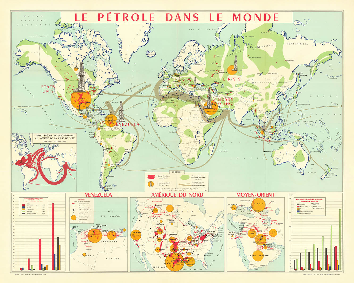
Immergiti nel mondo affascinante della cartografia di metà secolo con "Le Pétrole dans le Monde", una creazione magistrale del 1958 dell'Union des chambres syndicales du pétrole. Questa mappa straordinaria offre una rara finestra sull'industria petrolifera globale in un momento cruciale della storia, quando il petrolio stava rapidamente diventando il sangue vitale delle economie moderne e un attore centrale negli affari internazionali. Il titolo originale francese, elegantemente inciso, imposta il tono per un'opera che è tanto intellettualmente stimolante quanto visivamente accattivante—una vera testimonianza della fascinazione dell'epoca per il progresso industriale e la strategia geopolitica.
Commissionata dopo la crisi di Suez del 1956, questa mappa è più di un semplice record geografico; è una cronaca dei poteri in cambiamento e dei flussi energetici. I livelli tematici sono resi meticolosamente, con cerchi gialli e torri di piattaforme petrolifere che indicano le principali regioni produttrici di petrolio del mondo, la cui dimensione corrisponde al volume di greggio estratto. Le aree in ombra rossa rivelano l'estensione dei campi petroliferi attivi, mentre ampie distese verdi evidenziano i bacini sedimentari—regioni piene di potenziali riserve ancora da sfruttare. Frecce grigie tracciano elegantemente le principali rotte di esportazione, evocando il movimento incessante del petrolio attraverso continenti e oceani.
Lo stile cartografico è sia funzionale che decorativo, fondendo la chiarezza delle mappe industriali della metà del XX secolo con l'arte dei grafici murali vintage. La proiezione e il layout della mappa assicurano che ogni continente e oceano sia rappresentato con precisione, mentre una ricca tavolozza di colori e simboli audaci guida l'occhio dello spettatore dai vivaci campi petroliferi del Medio Oriente ai mercati emergenti del Sud America e oltre. Le mappe in dettaglio forniscono ulteriori granularità, concentrandosi su regioni strategiche come il Venezuela, gli Stati Uniti e il Medio Oriente, offrendo approfondimenti dettagliati sulle reti di oleodotti, le posizioni delle raffinerie e la geografia in evoluzione del petrolio.
Il contesto storico è intrecciato in tutto, con annotazioni e indizi visivi che parlano delle ansie e delle ambizioni dell'epoca. Una mappa in dettaglio, ad esempio, illustra l'impatto drammatico della crisi di Suez sulla distribuzione globale del petrolio, un promemoria di come geopolitica ed energia siano sempre state intrecciate. Due grafici meticolosamente disegnati tracciano la crescita esplosiva della produzione di petrolio dal 1900 al 1956 e il cambiamento dell'equilibrio delle fonti energetiche globali, catturando l'inevitabile ascesa del petrolio accanto al carbone, al gas naturale e all'energia idroelettrica.
"Le Pétrole dans le Monde" è una rara sintesi di arte, industria e storia. Si erge sia come documento del suo tempo sia come opera di bellezza duratura, offrendo a collezionisti e intenditori l'opportunità di possedere un pezzo tangibile della rivoluzione energetica del XX secolo. Che sia esposta in uno studio, in una biblioteca o in una sala riunioni, questa mappa invita a riflettere sulle forze che hanno plasmato il nostro mondo moderno e sull'attrattiva duratura dell'artigianato cartografico vintage.
Paesi e regioni su questa mappa
- Nord America
- Sud America
- Europa
- Africa
- Asia
- Medio Oriente (regione specificamente evidenziata)
- Stati Uniti (dettaglio in evidenza)
- Venezuela (dettaglio in evidenza)
- Regione mediterranea (evidenziata a causa della mappa in dettaglio sulla crisi di Suez)
- Vari paesi e regioni chiaramente etichettati all'interno di questi continenti e aree, come visibile sulla mappa
Caratteristiche e luoghi notevoli
- Icone gialle prominenti e torri di piattaforme petrolifere che indicano chiaramente le principali aree produttrici di petrolio
- Regioni colorate di rosso che segnano i campi petroliferi attivi
- Bacini sedimentari colorati di verde che indicano potenziali riserve di petrolio
- Frecce grigie che illustrano le principali rotte di esportazione di petrolio a livello globale
- Mappa in miniatura che illustra specificamente l'impatto della crisi di Suez del 1956 sulle rotte di distribuzione del petrolio
- Mappe dettagliate in miniatura del Venezuela, degli Stati Uniti e del Medio Oriente, che mostrano chiaramente oleodotti, progetti di oleodotti e posizioni delle raffinerie
- Grafici che rappresentano le tendenze storiche nella produzione di petrolio e nelle fonti di energia dal 1900 al 1956
- Etichettatura chiara degli oceani e dei mari principali, come l'Oceano Atlantico, l'Oceano Pacifico, l'Oceano Indiano e il Mare Mediterraneo
- Annotazioni e note storiche che forniscono contesto sull'industria petrolifera e sulle rotte commerciali
Contesto storico e di design
- Creato nel 1958 dall'Union des chambres syndicales du pétrole
- Stampato da Imp. Lafayette
- Cattura lo stato dell'industria petrolifera globale subito dopo la crisi di Suez (1956)
- Combina tecniche di mappatura tematica, politica e fisica tipiche delle mappe educative e industriali della metà del XX secolo
- Utilizza simboli chiari, colori vivaci e annotazioni dettagliate
- Riflette l'importanza geopolitica del petrolio e le dinamiche in evoluzione della produzione e del commercio di energia durante l'era della Guerra Fredda
Si prega di controllare attentamente le immagini per assicurarsi che una specifica città o luogo sia mostrato su questa mappa. Puoi anche contattarci e chiedere di controllare la mappa per te.
Questa è una mappa molto grande che deve essere ordinata in grande formato, in modo da poter distinguere facilmente tutti i dettagli.
Questa mappa appare fantastica in dimensioni fino a 100 pollici (250 cm). Se stai cercando una mappa più grande, ti preghiamo di contattarci.
Il modello nelle immagini dell'elenco sta tenendo la versione 16x20 pollici (40x50 cm) di questa mappa.
La quinta immagine dell'elenco mostra un esempio del mio servizio di personalizzazione della mappa.
Se stai cercando qualcosa di leggermente diverso, dai un'occhiata alla mia collezione delle migliori mappe antiche per vedere se qualcosa attira la tua attenzione.
Si prega di contattarmi per verificare se una certa posizione, punto di riferimento o caratteristica è mostrata su questa mappa.
Questa mappa sarebbe un meraviglioso regalo per un compleanno, Natale, Festa del Papà, un addio al lavoro, un anniversario o una festa di inaugurazione per qualcuno delle aree coperte da questa mappa.
Questa mappa è disponibile come stampa giclée su carta opaca archiviata senza acidi, oppure puoi acquistarla incorniciata. La cornice è una semplice cornice nera che si adatta alla maggior parte degli stili. Ti preghiamo di contattarci se desideri un colore o un materiale di cornice diverso. Le mie cornici sono incollate con acrilico di grado museale super chiaro (perspex/acrylite), che è significativamente meno riflettente del vetro, più sicuro e arriverà sempre in condizioni perfette.
This map is also available as a float framed canvas, sometimes known as a shadow gap framed canvas or canvas floater. The map is printed on artist's cotton canvas and then stretched over a handmade box frame. We then "float" the canvas inside a wooden frame, which is available in a range of colours (black, dark brown, oak, antique gold and white). This is a wonderful way to present a map without glazing in front. See some examples of float framed canvas maps and explore the differences between my different finishes.
For something truly unique, this map is also available in "Unique 3D", our trademarked process that dramatically transforms the map so that it has a wonderful sense of depth. We combine the original map with detailed topography and elevation data, so that mountains and the terrain really "pop". For more info and examples of 3D maps, check my Unique 3D page.
For most orders, delivery time is about 3 working days. Personalised and customised products take longer, as I have to do the personalisation and send it to you for approval, which usually takes 1 or 2 days.
Please note that very large framed orders usually take longer to make and deliver.
If you need your order to arrive by a certain date, please contact me before you order so that we can find the best way of making sure you get your order in time.
I print and frame maps and artwork in 23 countries around the world. This means your order will be made locally, which cuts down on delivery time and ensures that it won't be damaged during delivery. You'll never pay customs or import duty, and we'll put less CO2 into the air.
All of my maps and art prints are well packaged and sent in a rugged tube if unframed, or surrounded by foam if framed.
I try to send out all orders within 1 or 2 days of receiving your order, though some products (like face masks, mugs and tote bags) can take longer to make.
If you select Express Delivery at checkout your order we will prioritise your order and send it out by 1-day courier (Fedex, DHL, UPS, Parcelforce).
Next Day delivery is also available in some countries (US, UK, Singapore, UAE) but please try to order early in the day so that we can get it sent out on time.
My standard frame is a gallery style black ash hardwood frame. It is simple and quite modern looking. My standard frame is around 20mm (0.8in) wide.
I use super-clear acrylic (perspex/acrylite) for the frame glass. It's lighter and safer than glass - and it looks better, as the reflectivity is lower.
Six standard frame colours are available for free (black, dark brown, dark grey, oak, white and antique gold). Custom framing and mounting/matting is available if you're looking for something else.
Most maps, art and illustrations are also available as a framed canvas. We use matte (not shiny) cotton canvas, stretch it over a sustainably sourced box wood frame, and then 'float' the piece within a wood frame. The end result is quite beautiful, and there's no glazing to get in the way.
All frames are provided "ready to hang", with either a string or brackets on the back. Very large frames will have heavy duty hanging plates and/or a mounting baton. If you have any questions, please get in touch.
See some examples of my framed maps and framed canvas maps.
Alternatively, I can also supply old maps and artwork on canvas, foam board, cotton rag and other materials.
If you want to frame your map or artwork yourself, please read my size guide first.
Alcune delle mie vecchie mappe sono ora disponibili come tele incorniciate. Per favore contattami se desideri ordinare una dimensione che non è disponibile nel mio negozio.
Le vecchie mappe su tela sono un'alternativa interessante alle mappe incorniciate in modo convenzionale. A seconda del tuo gusto personale e dell'arredamento della stanza, le mappe su tela possono "risaltare" un po' di più rispetto a una mappa incorniciata.
My maps are extremely high quality reproductions of original maps.
I source original, rare maps from libraries, auction houses and private collections around the world, restore them at my London workshop, and then use specialist giclée inks and printers to create beautiful maps that look even better than the original.
My maps are printed on acid-free archival matte (not glossy) paper that feels very high quality and almost like card. In technical terms the paper weight/thickness is 10mil/200gsm. It's perfect for framing.
I print with Epson ultrachrome giclée UV fade resistant pigment inks - some of the best inks you can find.
I can also make maps on canvas, cotton rag and other exotic materials.
Learn more about The Unique Maps Co.
Map personalisation
If you're looking for the perfect anniversary or housewarming gift, I can personalise your map to make it truly unique. For example, I can add a short message, or highlight an important location, or add your family's coat of arms.
The options are almost infinite. Please see my map personalisation page for some wonderful examples of what's possible.
To order a personalised map, select "personalise your map" before adding it to your basket.
Get in touch if you're looking for more complex customisations and personalisations.
Map ageing
I have been asked hundreds of times over the years by customers if they could buy a map that looks even older.
Well, now you can, by selecting Aged before you add a map to your basket.
All the product photos you see on this page show the map in its Original form. This is what the map looks like today.
If you select Aged, I will age your map by hand, using a special and unique process developed through years of studying old maps, talking to researchers to understand the chemistry of aging paper, and of course... lots of practice!
If you're unsure, stick to the Original colour of the map. If you want something a bit darker and older looking, go for Aged.
Se non sei soddisfatto del tuo ordine per qualsiasi motivo, contattami per un rimborso senza problemi. Si prega di consultare la nostra politica di reso e rimborso per ulteriori informazioni.
Sono molto sicuro che ti piacerà la tua mappa restaurata o la stampa d'arte. Lo faccio dal 1984. Sono un venditore Etsy a 5 stelle. Ho venduto decine di migliaia di mappe e stampe d'arte e ho oltre 5.000 recensioni reali a 5 stelle.
Utilizzo un processo unico per restaurare mappe e opere d'arte che richiede molto tempo e lavoro. Trovare le mappe e le illustrazioni originali può richiedere mesi. Utilizzo tecnologia all'avanguardia e incredibilmente costosa per scannerizzare e restaurarle. Di conseguenza, garantisco che le mie mappe e stampe d'arte siano superiori alle altre - ecco perché posso offrire un rimborso senza problemi.
Quasi tutte le mie mappe e stampe d'arte sembrano fantastiche a grandi dimensioni (200 cm, 6,5 piedi+) e posso anche incorniciarle e consegnarle a te, tramite un corriere speciale per oggetti di grandi dimensioni. Contattami per discutere delle tue esigenze specifiche.
Or try searching for something!


