


Vecchia mappa dell'arcidiocesi di Treviri di Visscher, 1690: Coblenza, Bitburg, Cochem, Magonza, Mosella
20% di sconto su 2 — 33% di sconto su 3
Aggiungi qualsiasi due articoli idonei al tuo carrello per ricevere 20% di sconto. Aggiungi un terzo e sarà gratuito (equivalente a 33% di sconto quando acquisti tre).
Nessun codice necessario — l'offerta si applica automaticamente al checkout.
Valido su tutte le mappe standard e le stampe d'arte fine. Puoi mescolare e abbinare qualsiasi design.
Se desideri spedire articoli a più indirizzi, ti preghiamo di contattarci prima di effettuare il tuo ordine.
Le commissioni personalizzate e su misura sono escluse.
Contattaci se hai domande
-
![]() Handmade in the UK (we're based in London)
Handmade in the UK (we're based in London)

-
FREE worldwide delivery in 2-3 days ⓘ
Free delivery in 2-3 days
Your map should be delivered in 2-3 working days with free delivery, worldwide.
We make maps by hand locally in 23 countries. If you're buying a gift for someone in another country, we will make the map locally to them.
You will never pay import tax or customs duty.
Express delivery is available at checkout which can reduce the delivery time to 1-2 days.
Please note that personalised maps, and larger framed maps, can take longer to produce and deliver.
If you need your order to arrive by a certain date, contact me and we can discuss your options.
-
Complimentary gifting & design advice
ⓘ
Complimentary gifting & design advice
Available almost 24/7 on WhatsApp and email — we usually reply within minutes. We can help you:
- Choose a perfectly personalised gift
- Send a digital gift preview to the recipient
- Pick the ideal size for your wall
- Select the right finish and frame
Quick, friendly advice so you can order with confidence.
For last minute gifts, consider buying a digital gift card. We have over 5,000 maps and art prints to choose from.
-
90-day returns & 5-year guarantee
ⓘ
90 giorni per restituire e ricevere un rimborso
I prodotti possono essere restituiti entro 90 giorni per un rimborso completo, o cambio con un altro prodotto.
Per articoli personalizzati e su misura, potremmo offrirti un credito in negozio o una carta regalo non scadente, poiché non possiamo rivendere ordini personalizzati.
Se hai domande, contattaci. Per ulteriori informazioni, consulta la nostra politica di restituzione e cambio.

This is a museum-grade archival print from the original 1690 map — restored in our workshop and made to order on 220gsm archival matte paper or 400gsm artist's cotton canvas with pigment inks.
Professional framing & free personalisation available.
1. Choose a size
2. Frame & personalise your map
Make your map unique with framing, hand-drawn customisation, vintage ageing, pop art text, unique 3D styling and more.


Gift message & custom finish

If you want to add a gift message, or a finish (jigsaw, aluminium board, etc.) that is not available here, please request it in the "order note" when you check out.
Every order is custom made, so if you need the size adjusted slightly, or printed on an unusual material, just let us know. We've done thousands of custom orders over the years, so there's (almost) nothing we can't manage.
You can also contact us before you order, if you prefer!

- Handmade locally. No import duty or tax
- FREE worldwide delivery
- 90-day returns & 5-year product guarantee
- Questions? WhatsApp me any time
Own a piece of history
7,000+ 5 star reviews


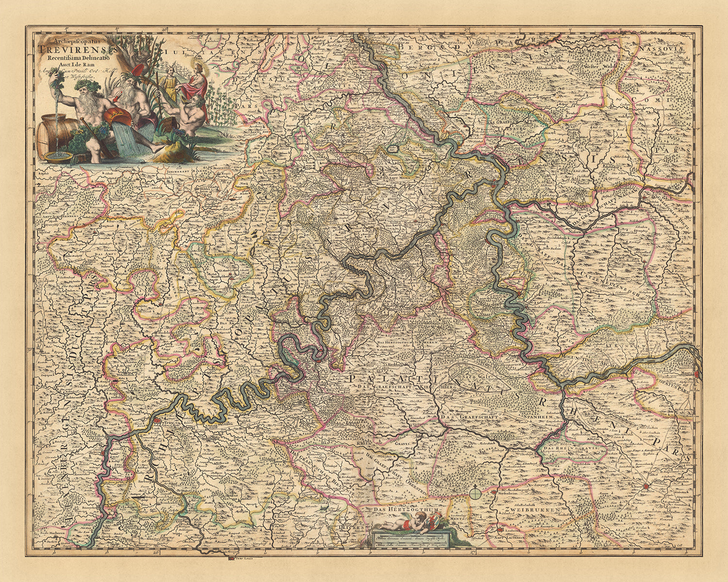
Immergiti nei dettagli intricati della 'Archiepiscopatus Trevirensis recentissima delineatio', una affascinante mappa antica dell'Arcidiocesi di Treviri, meticolosamente realizzata da Nicolaes Visscher II nel 1690. La mappa offre un affascinante istantanea del paesaggio storico e politico dell'epoca, con l'Arcidiocesi di Treviri al centro. La regione, ora parte della Germania moderna, è rappresentata in dettagli straordinari, riflettendo la rinomata precisione e il talento artistico di Visscher.
La mappa mostra cinque località notevoli: Coblenza, Bitburg, Cochem, Magonza e Mosella. Ogni città è contrassegnata con meticolosa attenzione, permettendo agli spettatori di apprezzare i layout urbani storici e il contesto geografico. Coblenza, situata alla confluenza dei fiumi Reno e Mosella, è una caratteristica chiave della mappa. Bitburg, con la sua ricca storia che risale all'epoca romana, e Cochem, un'importante città medievale di commercio e artigianato, sono anch'esse evidenziate.
Magonza, una città con una storia che si estende per oltre due millenni, è un'altra località significativa rappresentata sulla mappa. Era un importante centro commerciale durante l'Impero Romano e in seguito divenne una città importante nel Sacro Romano Impero. La Mosella, un fiume che scorre attraverso Francia, Lussemburgo e Germania, è anch'essa presente in modo prominente, sottolineando la sua importanza storica come via d'acqua vitale per il commercio e il trasporto.
Il nome completo della mappa, 'Archiepiscopatus Trevirensis recentissima delineatio', si traduce in 'La Delineazione Più Recente dell'Arcidiocesi di Treviri'. Questo titolo allude al focus della mappa sul territorio ecclesiastico dell'Arcidiocesi di Treviri, uno dei vescovadi più potenti e influenti del Sacro Romano Impero. Questa mappa, con il suo focus su una regione di tale significato storico e politico, non è solo uno strumento di navigazione, ma una finestra sul passato, offrendo una prospettiva unica sul mondo com'era conosciuto nel 1690.
Alcune delle località significative mostrate su questa mappa:
Arcidiocesi di Treviri:
- Treviri: Conosciuta come Augusta Treverorum durante l'epoca romana, era una città principale dell'Impero Romano ed è considerata la città più antica della Germania.
- Coblenza: Conosciuta come Confluentes in epoca romana, si trova alla confluenza dei fiumi Reno e Mosella.
- Magonza: Conosciuta come Mogontiacum in epoca romana, era un importante centro di commercio durante l'Impero Romano.
- Bitburg: Conosciuta come Beda Vicus in epoca romana, era un'importante città di commercio e artigianato.
- Cochem: Un'importante città medievale di commercio e artigianato.
- Bernkastel-Kues: Famosa per i suoi edifici medievali ben conservati.
- Traben-Trarbach: Un'importante città vinicola nella regione vinicola della Mosella.
- Wittlich: Conosciuta per il suo annuale festival del maiale e del folklore, il Säubrennerkirmes.
- Neumagen-Dhron: Conosciuta come Noviomagus Treverorum in epoca romana, è il villaggio vinicolo più antico della Germania.
- Prüm: Famosa per l'Abbazia di Prüm, una ex abbazia benedettina che aveva lo status di Abbazia Imperiale nel Sacro Romano Impero.
- Daun: Famosa per i suoi laghi vulcanici (maars).
- Manderscheid: Famosa per i suoi due castelli, l'Oberburg e il Niederburg.
- Gerolstein: Famosa per la sua acqua minerale naturale.
- Mayen: Famosa per la sua tradizione estrattiva di ardesia.
- Andernach: Conosciuta come Antunnacum in epoca romana, è una delle città più antiche della Germania.
- Boppard: Nota per le sue fortificazioni medievali ben conservate.
- Bingen am Rhein: Conosciuta come Bingium in epoca romana, è il punto di partenza della Valle del Medio Reno Superiore, patrimonio dell'umanità dell'UNESCO.
- Ingelheim am Rhein: Nota per il Palazzo Imperiale di Ingelheim, costruito da Carlo Magno.
- Bad Kreuznach: Nota per la sua struttura sanitaria per l'inalazione di radon.
- Idar-Oberstein: Nota per le sue miniere di gemme.
- Alzey: Conosciuta come Alteium in epoca romana, è associata al Nibelungenlied, un'epopea eroica dell'alta età medievale.
Fenomeni Naturali e Luoghi di Interesse:
- Fiume Mosella: Una importante via d'acqua per il commercio e il trasporto.
- Fiume Reno: Uno dei fiumi più lunghi e importanti d'Europa.
- Parco Nazionale dell'Eifel: Conosciuto per la sua storia geologica vulcanica.
- Hunsrück: Una catena montuosa bassa nota per le sue rocce di quarzite e i bellissimi sentieri escursionistici.
- Valle del Medio Reno Superiore: Un sito patrimonio dell'umanità dell'UNESCO noto per il suo paesaggio culturale.
Eventi Storici Notabili (1600-1690):
- Guerra dei Trent'Anni (1618-1648): Un conflitto devastante nella regione che ha portato a una significativa perdita di popolazione.
- Pace di Westfalia (1648): Ha posto fine alla Guerra dei Trent'Anni e ha portato a significativi cambiamenti territoriali.
- Annessione francese di Metz e Thionville (1659): Nell'ambito del Trattato dei Pirenei, queste città sono diventate parte della Francia.
Si prega di controllare attentamente le immagini per assicurarsi che una città o un luogo specifico sia mostrato su questa mappa. Puoi anche contattarci e chiedere di controllare la mappa per te.
Questa mappa appare fantastica in tutte le dimensioni: 12x16in (30.5x41cm), 16x20in (40.5x51cm), 18x24in (45.5x61cm), 24x30in (61x76cm), 32x40in (81.5x102cm), 40x50in (102x127cm), 48x60in (122x153cm) e 56x70in (142x178cm), ma appare ancora meglio quando stampata in grande.
Posso creare bellissime stampe di grandi dimensioni di questa mappa fino a 90in (229cm). Ti prego di contattarmi se stai cercando opzioni di incorniciatura più grandi, personalizzate o diverse.
Il modello nelle immagini dell'elenco tiene la versione 16x20in (40.5x51cm) di questa mappa.
La quinta immagine dell'elenco mostra un esempio del mio servizio di personalizzazione della mappa.
Se stai cercando qualcosa di leggermente diverso, dai un'occhiata alla mia collezione delle migliori mappe antiche d'Europa e delle città europee per vedere se qualcosa attira la tua attenzione.
Ti prego di contattarmi per verificare se una certa posizione, punto di riferimento o caratteristica è mostrata su questa mappa.
Questo sarebbe un meraviglioso regalo per un compleanno, Natale, Festa del Papà, pensionamento, anniversario o inaugurazione di una casa per qualcuno delle aree coperte da questa mappa.
Questa mappa è disponibile come stampa giclée su carta opaca archiviata senza acidi, oppure puoi acquistarla incorniciata. La cornice è una semplice cornice nera che si adatta alla maggior parte degli stili. Ti preghiamo di contattarci se desideri un colore o un materiale di cornice diverso. Le mie cornici sono rivestite con acrilico super chiaro di grado museale (perspex/acrylite), che è significativamente meno riflettente del vetro, più sicuro e arriverà sempre in perfette condizioni.
This map is also available as a float framed canvas, sometimes known as a shadow gap framed canvas or canvas floater. The map is printed on artist's cotton canvas and then stretched over a handmade box frame. We then "float" the canvas inside a wooden frame, which is available in a range of colours (black, dark brown, oak, antique gold and white). This is a wonderful way to present a map without glazing in front. See some examples of float framed canvas maps and explore the differences between my different finishes.
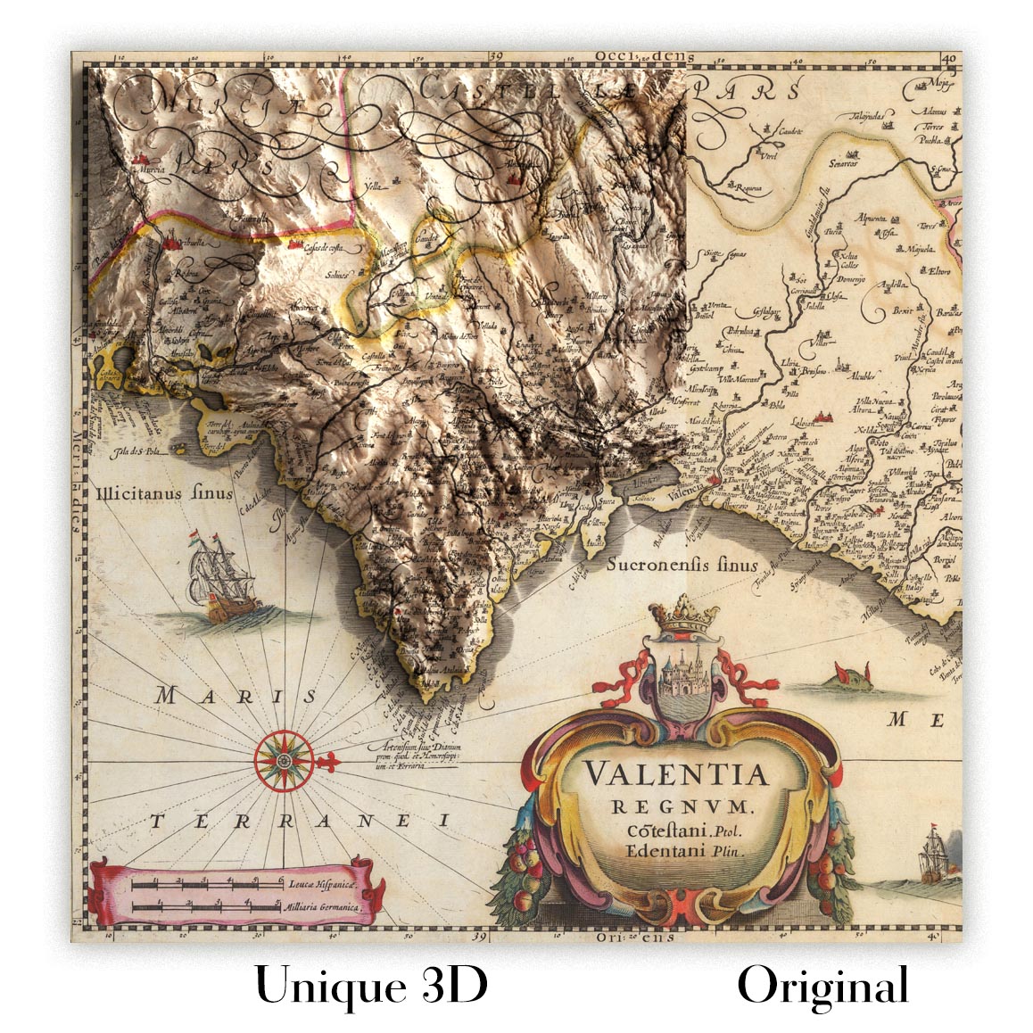
For something truly unique, this map is also available in "Unique 3D", our trademarked process that dramatically transforms the map so that it has a wonderful sense of depth. We combine the original map with detailed topography and elevation data, so that mountains and the terrain really "pop". For more info and examples of 3D maps, check my Unique 3D page.
For most orders, delivery time is about 3 working days. Personalised and customised products take longer, as I have to do the personalisation and send it to you for approval, which usually takes 1 or 2 days.
Please note that very large framed orders usually take longer to make and deliver.
If you need your order to arrive by a certain date, please contact me before you order so that we can find the best way of making sure you get your order in time.
I print and frame maps and artwork in 23 countries around the world. This means your order will be made locally, which cuts down on delivery time and ensures that it won't be damaged during delivery. You'll never pay customs or import duty, and we'll put less CO2 into the air.
All of my maps and art prints are well packaged and sent in a rugged tube if unframed, or surrounded by foam if framed.
I try to send out all orders within 1 or 2 days of receiving your order, though some products (like face masks, mugs and tote bags) can take longer to make.
If you select Express Delivery at checkout your order we will prioritise your order and send it out by 1-day courier (Fedex, DHL, UPS, Parcelforce).
Next Day delivery is also available in some countries (US, UK, Singapore, UAE) but please try to order early in the day so that we can get it sent out on time.
My standard frame is a gallery style black ash hardwood frame. It is simple and quite modern looking. My standard frame is around 20mm (0.8in) wide.
I use super-clear acrylic (perspex/acrylite) for the frame glass. It's lighter and safer than glass - and it looks better, as the reflectivity is lower.
Six standard frame colours are available for free (black, dark brown, dark grey, oak, white and antique gold). Custom framing and mounting/matting is available if you're looking for something else.
Most maps, art and illustrations are also available as a framed canvas. We use matte (not shiny) cotton canvas, stretch it over a sustainably sourced box wood frame, and then 'float' the piece within a wood frame. The end result is quite beautiful, and there's no glazing to get in the way.
All frames are provided "ready to hang", with either a string or brackets on the back. Very large frames will have heavy duty hanging plates and/or a mounting baton. If you have any questions, please get in touch.
See some examples of my framed maps and framed canvas maps.
Alternatively, I can also supply old maps and artwork on canvas, foam board, cotton rag and other materials.
If you want to frame your map or artwork yourself, please read my size guide first.
Alcune delle mie vecchie mappe sono ora disponibili come tele incorniciate. Per favore contattami se desideri ordinare una dimensione che non è disponibile nel mio negozio.
Le vecchie mappe su tela sono un'alternativa interessante alle mappe incorniciate in modo convenzionale. A seconda del tuo gusto personale e dell'arredamento della stanza, le mappe su tela possono "risaltare" un po' di più rispetto a una mappa incorniciata.
My maps are extremely high quality reproductions of original maps.
I source original, rare maps from libraries, auction houses and private collections around the world, restore them at my London workshop, and then use specialist giclée inks and printers to create beautiful maps that look even better than the original.
My maps are printed on acid-free archival matte (not glossy) paper that feels very high quality and almost like card. In technical terms the paper weight/thickness is 10mil/200gsm. It's perfect for framing.
I print with Epson ultrachrome giclée UV fade resistant pigment inks - some of the best inks you can find.
I can also make maps on canvas, cotton rag and other exotic materials.
Learn more about The Unique Maps Co.
Map personalisation
If you're looking for the perfect anniversary or housewarming gift, I can personalise your map to make it truly unique. For example, I can add a short message, or highlight an important location, or add your family's coat of arms.
The options are almost infinite. Please see my map personalisation page for some wonderful examples of what's possible.
To order a personalised map, select "personalise your map" before adding it to your basket.
Get in touch if you're looking for more complex customisations and personalisations.
Map ageing
I have been asked hundreds of times over the years by customers if they could buy a map that looks even older.
Well, now you can, by selecting Aged before you add a map to your basket.
All the product photos you see on this page show the map in its Original form. This is what the map looks like today.
If you select Aged, I will age your map by hand, using a special and unique process developed through years of studying old maps, talking to researchers to understand the chemistry of aging paper, and of course... lots of practice!
If you're unsure, stick to the Original colour of the map. If you want something a bit darker and older looking, go for Aged.
Se non sei soddisfatto del tuo ordine per qualsiasi motivo, contattami per un rimborso senza problemi. Si prega di consultare la nostra politica di reso e rimborso per ulteriori informazioni.
Sono molto sicuro che ti piacerà la tua mappa restaurata o la stampa d'arte. Lo faccio dal 1984. Sono un venditore Etsy a 5 stelle. Ho venduto decine di migliaia di mappe e stampe d'arte e ho oltre 5.000 recensioni reali a 5 stelle.
Utilizzo un processo unico per restaurare mappe e opere d'arte che richiede molto tempo e lavoro. Trovare le mappe e le illustrazioni originali può richiedere mesi. Utilizzo tecnologia all'avanguardia e incredibilmente costosa per scannerizzare e restaurarle. Di conseguenza, garantisco che le mie mappe e stampe d'arte siano superiori alle altre - ecco perché posso offrire un rimborso senza problemi.
Quasi tutte le mie mappe e stampe d'arte sembrano fantastiche a grandi dimensioni (200 cm, 6,5 piedi+) e posso anche incorniciarle e consegnarle a te, tramite un corriere speciale per oggetti di grandi dimensioni. Contattami per discutere delle tue esigenze specifiche.
Or try searching for something!


