

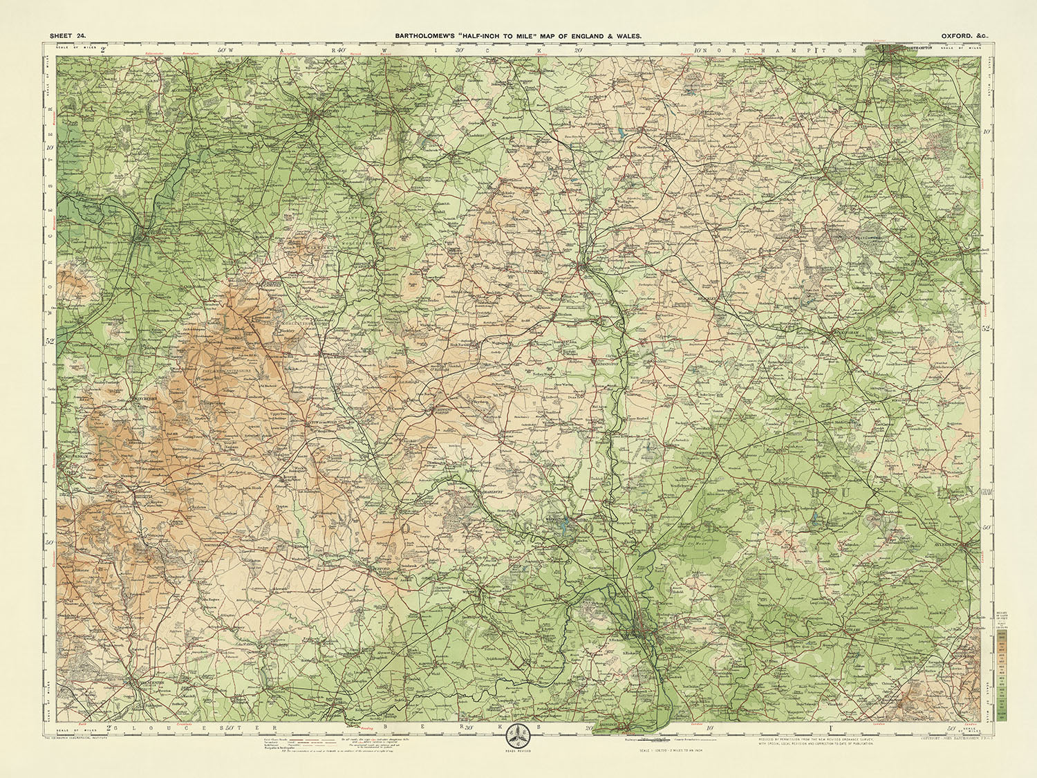
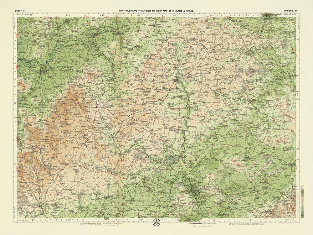


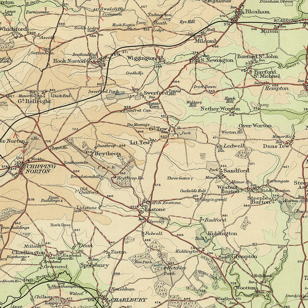


Mappa antica di Oxford di Bartholomew, 1901: Oxfordshire, Tamigi, Colline del Chiltern, Palazzo di Blenheim, Cotswolds, Foresta di Wychwood
Christmas Express Delivery
You can order up until 10am on December 22 with Express Delivery to receive your order by Christmas.
Unframed products are much more likely to arrive by Christmas. Framed products may arrive on time, but they move more slowly, particularly when couriers are so overloaded with packages.
Personalised orders are unlikely to arrive on time (but if you absolutely must have a personalised product, please contact me and I'll do my best to help!)
Contact me for info on last-minute deliveries.
Spend £250, Save £50 Christmas Express Delivery available
Christmas Express Delivery
You can order up until 10am on December 22 with Express Delivery to receive your order by Christmas.
Unframed products are much more likely to arrive by Christmas. Framed products may arrive on time, but they move more slowly, particularly when couriers are so overloaded with packages.
Personalised orders are unlikely to arrive on time (but if you absolutely must have a personalised product, please contact me and I'll do my best to help!)
Contact me for info on last-minute deliveries.
Spend £250, Save £50

-
![]() Handmade in the UK (we're based in London)
Handmade in the UK (we're based in London)
-
FREE delivery in 3-4 days ⓘ
Free delivery in 3-4 days
Your map should be delivered in 3-4 working days with free delivery, worldwide.
Please use Express Delivery at checkout for Christmas orders. Framed orders may arrive with Express Delivery, but it is not guaranteed.
New for 2025: After you order, you can send a beautiful gift preview by email, if you're worried it won't arrive on time.
We make maps by hand locally in 23 countries. If you're buying a gift for someone in another country, we will make the map locally to them.
You will never pay import tax or customs duty.
Check the Christmas delivery guide for order deadlines. Delivery times are starting to slow down, and will continue to slow down towards Christmas.
Express delivery is available at checkout which can reduce the delivery time to 1-2 days.
Please note that personalised maps, and larger framed maps, can take longer to produce and deliver.
If you need your order to arrive by a certain date, contact me and we can discuss your options.
-
FREE gift preview
ⓘ
Digital gift preview
New for 2025: After you complete your order, you can send a beautiful digital preview to the gift recipient. Just provide their email address and we'll do the rest. (Their email address will not be stored or used for any other purpose.)
This is perfect for Christmas gifting, particularly if you're concerned that your order might not arrive in time for Christmas.
-
90 day money back guarantee
ⓘ
90 giorni per restituire e ricevere un rimborso
I prodotti possono essere restituiti entro 90 giorni per un rimborso completo, o cambio con un altro prodotto.
Per articoli personalizzati e su misura, potremmo offrirti un credito in negozio o una carta regalo non scadente, poiché non possiamo rivendere ordini personalizzati.
Se hai domande, contattaci. Per ulteriori informazioni, consulta la nostra politica di restituzione e cambio.

My maps are rare, museum-grade, restored old maps sourced from libraries, auction houses and private collections across the globe.
Framing & free personalisation available
1. Select your size
2. Frame & personalise your map
There is limited framing & personalisation capacity available. Order by 10am tomorrow for Christmas delivery.


Gift message & custom finish

If you want to add a gift message, or a finish (jigsaw, aluminium board, etc.) that is not available here, please request it in the "order note" when you check out.
Every order is custom made, so if you need the size adjusted slightly, or printed on an unusual material, just let us know. We've done thousands of custom orders over the years, so there's (almost) nothing we can't manage.
You can also contact us before you order, if you prefer!

- Handmade locally. No import duty or tax
- FREE Delivery by Christmas
- Love it or your money back (90 days)
- Questions? WhatsApp me any time
Own a piece of history
5,000+ 5 star reviews


La mappa 24 - Oxford, creata dal illustre JG Bartholomew nel 1901, è un pezzo affascinante della storia cartografica. Questa mappa, parte della serie di punta di Bartholomew di mezzo pollice per miglio, offre una rappresentazione dettagliata e colorata della regione di Oxford, rendendola un artefatto prezioso per gli appassionati di storia e i collezionisti di mappe. Bartholomew, un rinomato cartografo scozzese, era celebrato per il suo approccio innovativo al design delle mappe, e questa particolare mappa esemplifica la sua maestria. La gradazione meticolosa delle bande di colore per rappresentare il rilievo del paesaggio è una testimonianza della sua abilità, fornendo un ritratto vivido e sfumato del terreno.
Il design della mappa è sia funzionale che esteticamente gradevole, catturando l'essenza della cartografia dei primi del XX secolo. La sua scala di mezzo pollice per miglio consente una visione dettagliata ma ampia della regione, rendendola uno strumento prezioso per ciclisti e turisti dell'epoca. L'uso di diversi strati di colore per rappresentare le varie altezze del terreno non solo migliora il suo fascino visivo ma offre anche una comprensione pratica del paesaggio. Questa tecnica innovativa ha distinto le mappe di Bartholomew da altre, mostrando il suo impegno sia per l'accuratezza che per l'arte.
Geograficamente, la mappa copre una gamma diversificata di caratteristiche, dalla vivace città di Oxford alle serene colline di Chiltern e Cotswold. Il fiume Tamigi e i suoi affluenti, tra cui il Cherwell e l'Evenlode, si snodano attraverso il paesaggio, aggiungendo complessità ai dettagli della mappa. Monumenti storici come il Palazzo di Blenheim e White Horse Hill sono evidenziati, offrendo uno sguardo sul ricco patrimonio della regione. La mappa mette anche in risalto infrastrutture significative, tra cui la Great Western Railway e il Canale di Oxford, riflettendo i progressi dell'epoca nel trasporto.
La mappa si estende oltre l'Oxfordshire, comprendendo parti del Buckinghamshire, Northamptonshire e Berkshire. Città come Aylesbury, Banbury e Reading sono contrassegnate, ciascuna con la sua unica importanza storica e culturale. La rappresentazione dettagliata di questi insediamenti offre uno spaccato affascinante dello sviluppo della regione all'inizio del secolo. Inoltre, caratteristiche naturali come le foreste di Wychwood e Bernwood sono rappresentate, mostrando la lussureggiante vegetazione e la bellezza naturale dell'area.
Storicamente, questa mappa è significativa poiché riflette il crescente interesse per i viaggi ricreativi e il ciclismo all'inizio del 1900. Il lavoro di Bartholomew non solo forniva strumenti di navigazione pratici ma ispirava anche esplorazione e avventura. La rappresentazione dettagliata e accurata del paesaggio la rendeva un compagno essenziale per i viaggiatori dell'epoca. Oggi, serve come un prezioso documento storico, offrendo spunti sulla geografia, l'infrastruttura e i monumenti culturali della regione di Oxford oltre un secolo fa.
Città e paesi su questa mappa
- Oxfordshire:
- Oxford
- Banbury
- Bicester
- Witney
- Chipping Norton
- Thame
- Woodstock
- Charlbury
- Wallingford
- Abingdon
-
Didcot
-
Buckinghamshire:
- Aylesbury
- Buckingham
- Winslow
-
Princes Risborough
Caratteristiche e Monumenti Notabili
- Fiumi:
- Fiume Tamigi
- Fiume Cherwell
-
Fiume Evenlode
-
Ferrovie:
- Great Western Railway
-
London and North Western Railway
-
Foreste e Boschi:
- Foresta di Wychwood
-
Foresta di Bernwood
-
Colline:
- Colline Chiltern
-
Colline Cotswold
-
Monumenti Storici:
- Palazzo di Blenheim
-
Collina del Cavallo Bianco
-
Canali:
- Canale di Oxford
-
Canale Grand Union
-
Strade:
-
Strade principali che collegano Oxford alle regioni circostanti
-
Parchi:
- Parco di Shotover
-
Parco di Cornbury
-
Ponti:
- Ponte di Folly
- Ponte di Magdalen
Contesto storico e di design
- Cartografo/Editore: JG Bartholomew, un rinomato cartografo scozzese noto per i suoi design di mappe dettagliati e innovativi.
- Data di creazione: 1901
- Scala: Mezza pollice per miglio (1:126,720), che consente una rappresentazione dettagliata coprendo un'ampia area.
- Design e Stile:
- Utilizza diversi strati di colore per rappresentare il rilievo del paesaggio.
- Gradazione sottile e innovativa delle bande di colore per mostrare il terreno a diverse altezze.
- Significato Storico:
- Riflette le tecniche cartografiche del primo XX secolo e il crescente interesse per i viaggi ricreativi e il ciclismo.
- Fornisce intuizioni storiche sulla geografia e l'infrastruttura della regione di Oxford all'inizio del secolo.
- Utilizzo Pratico: Progettata per ciclisti e turisti, evidenziando il suo utilizzo pratico per la navigazione e l'esplorazione.
- Copertura Geografica: Copre parti dell'Inghilterra, concentrandosi in particolare sulla regione intorno a Oxford, inclusi parti di Oxfordshire, Buckinghamshire, Northamptonshire e Berkshire.
Si prega di controllare le immagini per assicurarsi che una specifica città o luogo sia mostrato su questa mappa. Puoi anche contattarci e chiedere di controllare la mappa per te.
Questa mappa sembra ottima in ogni dimensione, ma consiglio sempre di optare per una dimensione più grande se hai spazio. In questo modo puoi facilmente distinguere tutti i dettagli.
Questa mappa appare incredibile in dimensioni fino a 70 pollici (180 cm). Se stai cercando una mappa più grande, ti preghiamo di contattarci.
Si prega di notare: le etichette su questa mappa sono difficili da leggere se ordini una mappa che è 20 pollici (50 cm) o più piccola. La mappa è comunque molto attraente, ma se desideri leggere facilmente la mappa, ti preghiamo di acquistare una dimensione più grande.
Il modello nelle immagini dell'annuncio tiene la versione 18x24 pollici (45x60 cm) di questa mappa.
La quinta immagine dell'annuncio mostra un esempio del mio servizio di personalizzazione delle mappe.
Se stai cercando qualcosa di leggermente diverso, dai un'occhiata alla mia collezione delle migliori mappe antiche per vedere se qualcosa cattura la tua attenzione.
Ti preghiamo di contattarmi per verificare se una certa posizione, monumento o caratteristica è mostrato su questa mappa.
Questo sarebbe un meraviglioso regalo per un compleanno, Natale, Festa del Papà, partenza dal lavoro, anniversario o inaugurazione della casa per qualcuno delle aree coperte da questa mappa.
Questa mappa è disponibile come stampa giclée su carta opaca archiviata senza acidi, oppure puoi acquistarla incorniciata. La cornice è una bella e semplice cornice nera che si adatta alla maggior parte degli stili. Ti preghiamo di contattarci se desideri un colore o un materiale diverso per la cornice. Le mie cornici sono vetriate con acrilico super chiaro di qualità museale (perspex/acrylite), che è significativamente meno riflettente del vetro, più sicuro e arriverà sempre in perfette condizioni.
This map is also available as a float framed canvas, sometimes known as a shadow gap framed canvas or canvas floater. The map is printed on artist's cotton canvas and then stretched over a handmade box frame. We then "float" the canvas inside a wooden frame, which is available in a range of colours (black, dark brown, oak, antique gold and white). This is a wonderful way to present a map without glazing in front. See some examples of float framed canvas maps and explore the differences between my different finishes.
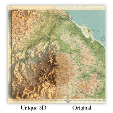
For something truly unique, this map is also available in "Unique 3D", our trademarked process that dramatically transforms the map so that it has a wonderful sense of depth. We combine the original map with detailed topography and elevation data, so that mountains and the terrain really "pop". For more info and examples of 3D maps, check my Unique 3D page.
For most orders, delivery time is about 3 working days. Personalised and customised products take longer, as I have to do the personalisation and send it to you for approval, which usually takes 1 or 2 days.
Please note that very large framed orders usually take longer to make and deliver.
If you need your order to arrive by a certain date, please contact me before you order so that we can find the best way of making sure you get your order in time.
I print and frame maps and artwork in 23 countries around the world. This means your order will be made locally, which cuts down on delivery time and ensures that it won't be damaged during delivery. You'll never pay customs or import duty, and we'll put less CO2 into the air.
All of my maps and art prints are well packaged and sent in a rugged tube if unframed, or surrounded by foam if framed.
I try to send out all orders within 1 or 2 days of receiving your order, though some products (like face masks, mugs and tote bags) can take longer to make.
If you select Express Delivery at checkout your order we will prioritise your order and send it out by 1-day courier (Fedex, DHL, UPS, Parcelforce).
Next Day delivery is also available in some countries (US, UK, Singapore, UAE) but please try to order early in the day so that we can get it sent out on time.
My standard frame is a gallery style black ash hardwood frame. It is simple and quite modern looking. My standard frame is around 20mm (0.8in) wide.
I use super-clear acrylic (perspex/acrylite) for the frame glass. It's lighter and safer than glass - and it looks better, as the reflectivity is lower.
Six standard frame colours are available for free (black, dark brown, dark grey, oak, white and antique gold). Custom framing and mounting/matting is available if you're looking for something else.
Most maps, art and illustrations are also available as a framed canvas. We use matte (not shiny) cotton canvas, stretch it over a sustainably sourced box wood frame, and then 'float' the piece within a wood frame. The end result is quite beautiful, and there's no glazing to get in the way.
All frames are provided "ready to hang", with either a string or brackets on the back. Very large frames will have heavy duty hanging plates and/or a mounting baton. If you have any questions, please get in touch.
See some examples of my framed maps and framed canvas maps.
Alternatively, I can also supply old maps and artwork on canvas, foam board, cotton rag and other materials.
If you want to frame your map or artwork yourself, please read my size guide first.
Alcune delle mie vecchie mappe sono ora disponibili come tele incorniciate. Per favore contattami se desideri ordinare una dimensione che non è disponibile nel mio negozio.
Le vecchie mappe su tela sono un'alternativa interessante alle mappe incorniciate in modo convenzionale. A seconda del tuo gusto personale e dell'arredamento della stanza, le mappe su tela possono "risaltare" un po' di più rispetto a una mappa incorniciata.
My maps are extremely high quality reproductions of original maps.
I source original, rare maps from libraries, auction houses and private collections around the world, restore them at my London workshop, and then use specialist giclée inks and printers to create beautiful maps that look even better than the original.
My maps are printed on acid-free archival matte (not glossy) paper that feels very high quality and almost like card. In technical terms the paper weight/thickness is 10mil/200gsm. It's perfect for framing.
I print with Epson ultrachrome giclée UV fade resistant pigment inks - some of the best inks you can find.
I can also make maps on canvas, cotton rag and other exotic materials.
Learn more about The Unique Maps Co.
Map personalisation
If you're looking for the perfect anniversary or housewarming gift, I can personalise your map to make it truly unique. For example, I can add a short message, or highlight an important location, or add your family's coat of arms.
The options are almost infinite. Please see my map personalisation page for some wonderful examples of what's possible.
To order a personalised map, select "personalise your map" before adding it to your basket.
Get in touch if you're looking for more complex customisations and personalisations.
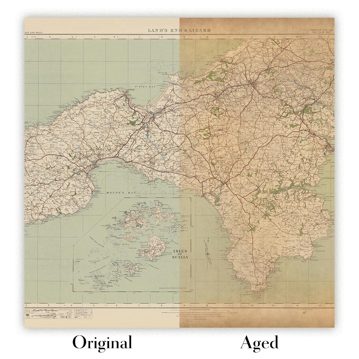
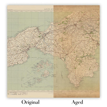
Map ageing
I have been asked hundreds of times over the years by customers if they could buy a map that looks even older.
Well, now you can, by selecting Aged before you add a map to your basket.
All the product photos you see on this page show the map in its Original form. This is what the map looks like today.
If you select Aged, I will age your map by hand, using a special and unique process developed through years of studying old maps, talking to researchers to understand the chemistry of aging paper, and of course... lots of practice!
If you're unsure, stick to the Original colour of the map. If you want something a bit darker and older looking, go for Aged.
Se non sei soddisfatto del tuo ordine per qualsiasi motivo, contattami per un rimborso senza problemi. Si prega di consultare la nostra politica di reso e rimborso per ulteriori informazioni.
Sono molto sicuro che ti piacerà la tua mappa restaurata o la stampa d'arte. Lo faccio dal 1984. Sono un venditore Etsy a 5 stelle. Ho venduto decine di migliaia di mappe e stampe d'arte e ho oltre 5.000 recensioni reali a 5 stelle.
Utilizzo un processo unico per restaurare mappe e opere d'arte che richiede molto tempo e lavoro. Trovare le mappe e le illustrazioni originali può richiedere mesi. Utilizzo tecnologia all'avanguardia e incredibilmente costosa per scannerizzare e restaurarle. Di conseguenza, garantisco che le mie mappe e stampe d'arte siano superiori alle altre - ecco perché posso offrire un rimborso senza problemi.
Quasi tutte le mie mappe e stampe d'arte sembrano fantastiche a grandi dimensioni (200 cm, 6,5 piedi+) e posso anche incorniciarle e consegnarle a te, tramite un corriere speciale per oggetti di grandi dimensioni. Contattami per discutere delle tue esigenze specifiche.
Or try searching for something!


