


Mappa militare antica degli Stati Uniti di Rand McNally, 1944: Seconda Guerra Mondiale, aeroporti, basi navali e militari

-
![]() Handmade in the UK (we're based in London)
Handmade in the UK (we're based in London)
-
FREE worldwide delivery in 2-3 days ⓘ
Free delivery in 2-3 days
Your map should be delivered in 2-3 working days with free delivery, worldwide.
We make maps by hand locally in 23 countries. If you're buying a gift for someone in another country, we will make the map locally to them.
You will never pay import tax or customs duty.
Express delivery is available at checkout which can reduce the delivery time to 1-2 days.
Please note that personalised maps, and larger framed maps, can take longer to produce and deliver.
If you need your order to arrive by a certain date, contact me and we can discuss your options.
-
90 day money back guarantee
ⓘ
90 giorni per restituire e ottenere un rimborso
I prodotti possono essere restituiti entro 90 giorni per un rimborso completo, o scambio con un altro prodotto.
Per articoli personalizzati o su misura, potremmo offrirti un credito in negozio o una carta regalo non scadente, poiché non possiamo rivendere ordini personalizzati.
Se hai domande, contattaci. Per ulteriori informazioni, consulta la nostra politica di restituzione e scambio.

My maps are rare, museum-grade, restored old maps sourced from libraries, auction houses and private collections across the globe.
Framing & free personalisation available
1. Select your size
2. Frame & personalise your map
Make your map unique with framing, hand-drawn customisation, vintage ageing, pop art text, unique 3D styling and moreGift message & custom finish

If you want to add a gift message, or a finish (jigsaw, aluminium board, etc.) that is not available here, please request it in the "order note" when you check out.
Every order is custom made, so if you need the size adjusted slightly, or printed on an unusual material, just let us know. We've done thousands of custom orders over the years, so there's (almost) nothing we can't manage.
You can also contact us before you order, if you prefer!

- Handmade locally. No import duty or tax
- FREE Delivery. Arrives in 2-3 days
- Love it or your money back
- Questions? WhatsApp me any time
Own a piece of history
5,000+ 5 star reviews


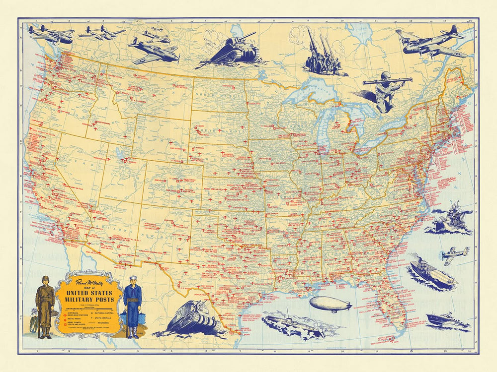
La "Mappa Rand McNally dei Posti Militari degli Stati Uniti" del 1944 è uno sguardo affascinante nel cuore strategico dell'America durante la Seconda Guerra Mondiale. Realizzata dalla rinomata Rand McNally & Company, questa mappa traccia meticolosamente la vasta rete di installazioni militari negli Stati Uniti. Conosciute per la loro precisione e dettaglio, le mappe di Rand McNally erano strumenti indispensabili per la navigazione e la strategia, e questo particolare pezzo riflette l'attività militare intensa dell'epoca. La mappa funge da documento storico, illustrando l'ampia infrastruttura che supportava gli sforzi globali dell'esercito statunitense.
Questa mappa tematica è un ricco arazzo di simboli, ognuno dei quali rappresenta aeroporti, basi navali e campi dell'esercito, fornendo una panoramica dettagliata del paesaggio militare. Il design della mappa è sia funzionale che artistico, con illustrazioni di aerei militari e personale, che aggiungono un elemento visivo dinamico. Il retro della mappa include sagome di 20 diversi aerei militari statunitensi, offrendo un'affascinante visione della tecnologia aeronautica dell'epoca. Elenca anche le tariffe mensili per ufficiali e personale arruolato, riflettendo gli aspetti economici della vita militare.
Geograficamente, la mappa copre l'intero territorio degli Stati Uniti, evidenziando le principali città e paesi che hanno svolto ruoli fondamentali durante la guerra. Dalle affollate strade di New York City ai porti strategici di San Diego, ogni luogo è una testimonianza degli sforzi bellici della nazione. La mappa delinea anche i principali fiumi e i confini statali, fornendo una vista completa del paesaggio naturale e politico del paese. Questa rappresentazione intricata dell'America durante un periodo storico critico rende la mappa un pezzo prezioso per storici e collezionisti.
Il significato storico di questa mappa non può essere sottovalutato. Creata all'apice della Seconda Guerra Mondiale, offre un'istantanea della pianificazione strategica e dell'allocazione delle risorse dell'esercito statunitense. La mappa non solo serviva come strumento pratico per la logistica militare, ma anche come un incoraggiamento morale, mostrando la prontezza e la forza della nazione. L'inclusione dei Club USO e delle tariffe salariali militari sul retro evidenzia le dimensioni sociali ed economiche dello sforzo bellico, offrendo una visione olistica della vita durante questo periodo turbolento.
L'eredità della Rand McNally & Company nella cartografia è evidente nei dettagli meticolosi e nella precisione di questa mappa. Come uno dei principali cartografi del XIX e XX secolo, il loro lavoro è stato cruciale nel plasmare la comprensione pubblica della geografia e della strategia militare. Questa mappa è una testimonianza della loro esperienza e dedizione, catturando un momento cruciale nella storia con precisione e arte. Essa rappresenta un artefatto prezioso per collezionisti, storici e chiunque sia interessato al ricco arazzo del passato americano.
Città e paesi su questa mappa
- Stati Uniti:
- New York City
- Los Angeles
- Chicago
- Houston
- Philadelphia
- Phoenix
- San Antonio
- San Diego
- Dallas
- San Jose
- Austin
- Jacksonville
- Fort Worth
- Columbus
- San Francisco
- Charlotte
- Indianapolis
- Seattle
- Denver
- Washington, D.C.
- Boston
- El Paso
- Nashville
- Detroit
- Oklahoma City
- Portland
- Las Vegas
- Memphis
- Louisville
- Baltimore
- Milwaukee
- Albuquerque
- Tucson
- Fresno
- Sacramento
- Kansas City
- Long Beach
- Mesa
- Virginia Beach
- Atlanta
- Colorado Springs
- Omaha
- Raleigh
- Miami
- Oakland
- Minneapolis
- Tulsa
- Wichita
- New Orleans
- Arlington
Caratteristiche e monumenti notevoli
- Illustrazioni:
- Velivoli militari
- Soldati e attrezzature militari
- Corpi idrici:
- I principali fiumi e laghi sono rappresentati.
- Confini:
- I confini statali sono chiaramente segnati.
- Altre caratteristiche notevoli:
- Vari simboli militari che indicano diversi tipi di installazioni.
Contesto storico e di design
- Nome della mappa: Mappa Rand McNally dei Posti Militari degli Stati Uniti
- Data di creazione: 1944
- Cartografo/Editore: Rand McNally & Company
- Argomenti e temi:
- Posti militari durante la Seconda Guerra Mondiale
- Simboli per aeroporti, basi, stazioni, basi navali, accampamenti, forti e posti
- Design/Stile:
- Mappa tematica con illustrazioni di velivoli e personale militare
- I dettagli sul retro includono silhouette di velivoli militari, tariffe di pagamento militari e Club USO al 15 marzo 1944
- Significato storico: Riflette le operazioni militari statunitensi durante la Seconda Guerra Mondiale.
Si prega di controllare attentamente le immagini per assicurarsi che una specifica città o luogo sia mostrato su questa mappa. Puoi anche contattarci e chiedere di controllare la mappa per te.
Questa mappa appare fantastica in ogni dimensione, ma consiglio sempre di optare per una dimensione più grande se hai spazio. In questo modo puoi facilmente distinguere tutti i dettagli.
Questa mappa sembra incredibile in dimensioni fino a 100in (250cm). Se stai cercando una mappa più grande, per favore contattaci.
Si prega di notare: le etichette su questa mappa sono difficili da leggere se ordini una mappa di 20in (50cm) o più piccola. La mappa è ancora molto attraente, ma se desideri leggere facilmente la mappa, ti preghiamo di acquistare una dimensione più grande.
Il modello nelle immagini dell'elenco sta tenendo la versione 18x24in (45x60cm) di questa mappa.
La quinta immagine dell'elenco mostra un esempio del mio servizio di personalizzazione della mappa.
Se stai cercando qualcosa di leggermente diverso, dai un'occhiata alla mia collezione delle migliori vecchie mappe per vedere se qualcosa attira la tua attenzione.
Per favore contattami per verificare se una certa posizione, monumento o caratteristica è mostrata su questa mappa.
Questa sarebbe un regalo meraviglioso per un compleanno, Natale, Festa del Papà, partenza dal lavoro, anniversario o inaugurazione della casa per qualcuno delle aree coperte da questa mappa.
Questa mappa è disponibile come stampa giclée su carta opaca archiviata senza acidi, oppure puoi acquistarla incorniciata. La cornice è una semplice cornice nera che si adatta alla maggior parte degli stili. Ti preghiamo di contattarci se desideri un colore o un materiale di cornice diverso. Le mie cornici sono dotate di un acrilico super chiaro di grado museale (perspex/acrylite), che è significativamente meno riflettente del vetro, più sicuro e arriverà sempre in perfette condizioni.
This map is also available as a float framed canvas, sometimes known as a shadow gap framed canvas or canvas floater. The map is printed on artist's cotton canvas and then stretched over a handmade box frame. We then "float" the canvas inside a wooden frame, which is available in a range of colours (black, dark brown, oak, antique gold and white). This is a wonderful way to present a map without glazing in front. See some examples of float framed canvas maps and explore the differences between my different finishes.
For something truly unique, this map is also available in "Unique 3D", our trademarked process that dramatically transforms the map so that it has a wonderful sense of depth. We combine the original map with detailed topography and elevation data, so that mountains and the terrain really "pop". For more info and examples of 3D maps, check my Unique 3D page.
For most orders, delivery time is about 3 working days. Personalised and customised products take longer, as I have to do the personalisation and send it to you for approval, which usually takes 1 or 2 days.
Please note that very large framed orders usually take longer to make and deliver.
If you need your order to arrive by a certain date, please contact me before you order so that we can find the best way of making sure you get your order in time.
I print and frame maps and artwork in 23 countries around the world. This means your order will be made locally, which cuts down on delivery time and ensures that it won't be damaged during delivery. You'll never pay customs or import duty, and we'll put less CO2 into the air.
All of my maps and art prints are well packaged and sent in a rugged tube if unframed, or surrounded by foam if framed.
I try to send out all orders within 1 or 2 days of receiving your order, though some products (like face masks, mugs and tote bags) can take longer to make.
If you select Express Delivery at checkout your order we will prioritise your order and send it out by 1-day courier (Fedex, DHL, UPS, Parcelforce).
Next Day delivery is also available in some countries (US, UK, Singapore, UAE) but please try to order early in the day so that we can get it sent out on time.
My standard frame is a gallery style black ash hardwood frame. It is simple and quite modern looking. My standard frame is around 20mm (0.8in) wide.
I use super-clear acrylic (perspex/acrylite) for the frame glass. It's lighter and safer than glass - and it looks better, as the reflectivity is lower.
Six standard frame colours are available for free (black, dark brown, dark grey, oak, white and antique gold). Custom framing and mounting/matting is available if you're looking for something else.
Most maps, art and illustrations are also available as a framed canvas. We use matte (not shiny) cotton canvas, stretch it over a sustainably sourced box wood frame, and then 'float' the piece within a wood frame. The end result is quite beautiful, and there's no glazing to get in the way.
All frames are provided "ready to hang", with either a string or brackets on the back. Very large frames will have heavy duty hanging plates and/or a mounting baton. If you have any questions, please get in touch.
See some examples of my framed maps and framed canvas maps.
Alternatively, I can also supply old maps and artwork on canvas, foam board, cotton rag and other materials.
If you want to frame your map or artwork yourself, please read my size guide first.
Alcune delle mie vecchie mappe sono ora disponibili come tele incorniciate. Per favore contattami se desideri ordinare una dimensione che non è disponibile nel mio negozio.
Le vecchie mappe su tela sono un'alternativa interessante alle mappe incorniciate in modo convenzionale. A seconda del tuo gusto personale e dell'arredamento della stanza, le mappe su tela possono "risaltare" un po' di più rispetto a una mappa incorniciata.
My maps are extremely high quality reproductions of original maps.
I source original, rare maps from libraries, auction houses and private collections around the world, restore them at my London workshop, and then use specialist giclée inks and printers to create beautiful maps that look even better than the original.
My maps are printed on acid-free archival matte (not glossy) paper that feels very high quality and almost like card. In technical terms the paper weight/thickness is 10mil/200gsm. It's perfect for framing.
I print with Epson ultrachrome giclée UV fade resistant pigment inks - some of the best inks you can find.
I can also make maps on canvas, cotton rag and other exotic materials.
Learn more about The Unique Maps Co.
Map personalisation
If you're looking for the perfect anniversary or housewarming gift, I can personalise your map to make it truly unique. For example, I can add a short message, or highlight an important location, or add your family's coat of arms.
The options are almost infinite. Please see my map personalisation page for some wonderful examples of what's possible.
To order a personalised map, select "personalise your map" before adding it to your basket.
Get in touch if you're looking for more complex customisations and personalisations.
Map ageing
I have been asked hundreds of times over the years by customers if they could buy a map that looks even older.
Well, now you can, by selecting Aged before you add a map to your basket.
All the product photos you see on this page show the map in its Original form. This is what the map looks like today.
If you select Aged, I will age your map by hand, using a special and unique process developed through years of studying old maps, talking to researchers to understand the chemistry of aging paper, and of course... lots of practice!
If you're unsure, stick to the Original colour of the map. If you want something a bit darker and older looking, go for Aged.
Se non sei soddisfatto del tuo ordine per qualsiasi motivo, contattami per un rimborso senza problemi. Si prega di consultare la nostra politica di reso e rimborso per ulteriori informazioni.
Sono molto sicuro che ti piacerà la tua mappa restaurata o la stampa d'arte. Lo faccio dal 1984. Sono un venditore Etsy a 5 stelle. Ho venduto decine di migliaia di mappe e stampe d'arte e ho oltre 5.000 recensioni reali a 5 stelle.
Utilizzo un processo unico per restaurare mappe e opere d'arte che richiede molto tempo e lavoro. Trovare le mappe e le illustrazioni originali può richiedere mesi. Utilizzo tecnologia all'avanguardia e incredibilmente costosa per scannerizzare e restaurarle. Di conseguenza, garantisco che le mie mappe e stampe d'arte siano superiori alle altre - ecco perché posso offrire un rimborso senza problemi.
Quasi tutte le mie mappe e stampe d'arte sembrano fantastiche a grandi dimensioni (200 cm, 6,5 piedi+) e posso anche incorniciarle e consegnarle a te, tramite un corriere speciale per oggetti di grandi dimensioni. Contattami per discutere delle tue esigenze specifiche.
Or try searching for something!


