


Vecchia mappa pittorica della Corsica di Liozu, 1951: Ajaccio, Corte, Bastia, Napoleone, Montagne

-
![]() Handmade in the UK (we're based in London)
Handmade in the UK (we're based in London)
-
FREE worldwide delivery in 2-3 days ⓘ
Free delivery in 2-3 days
Your map should be delivered in 2-3 working days with free delivery, worldwide.
We make maps by hand locally in 23 countries. If you're buying a gift for someone in another country, we will make the map locally to them.
You will never pay import tax or customs duty.
Express delivery is available at checkout which can reduce the delivery time to 1-2 days.
Please note that personalised maps, and larger framed maps, can take longer to produce and deliver.
If you need your order to arrive by a certain date, contact me and we can discuss your options.
-
90 day money back guarantee
ⓘ
90 giorni per restituire e ottenere un rimborso
I prodotti possono essere restituiti entro 90 giorni per un rimborso completo, o scambio con un altro prodotto.
Per articoli personalizzati o su misura, potremmo offrirti un credito in negozio o una carta regalo non scadente, poiché non possiamo rivendere ordini personalizzati.
Se hai domande, contattaci. Per ulteriori informazioni, consulta la nostra politica di restituzione e scambio.

My maps are rare, museum-grade, restored old maps sourced from libraries, auction houses and private collections across the globe.
Framing & free personalisation available
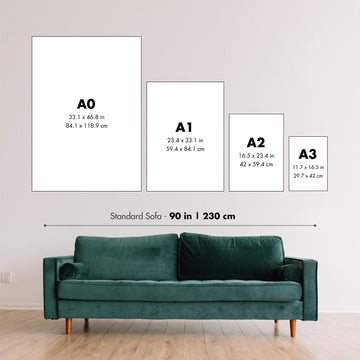
1. Select your size
2. Frame & personalise your map
Make your map unique with framing, hand-drawn customisation, vintage ageing, pop art text, unique 3D styling and moreGift message & custom finish

If you want to add a gift message, or a finish (jigsaw, aluminium board, etc.) that is not available here, please request it in the "order note" when you check out.
Every order is custom made, so if you need the size adjusted slightly, or printed on an unusual material, just let us know. We've done thousands of custom orders over the years, so there's (almost) nothing we can't manage.
You can also contact us before you order, if you prefer!

- Handmade locally. No import duty or tax
- FREE Delivery. Arrives in 2-3 days
- Love it or your money back
- Questions? WhatsApp me any time
Own a piece of history
5,000+ 5 star reviews


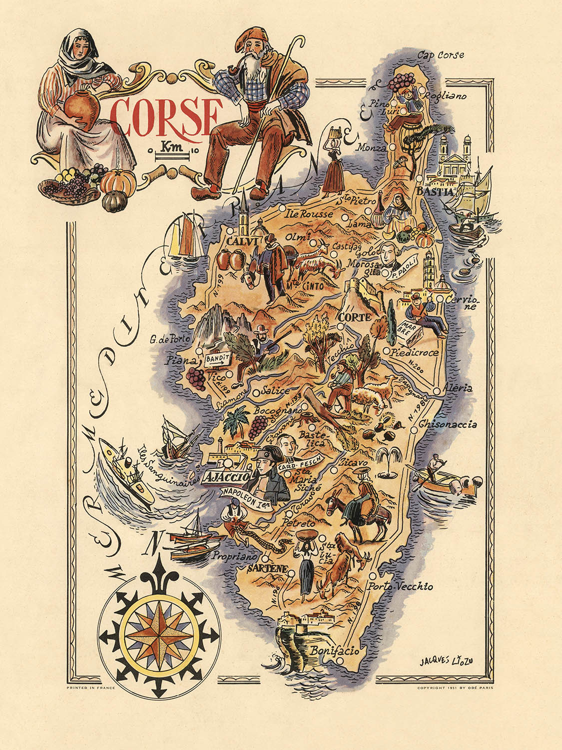
La mappa "Corse", realizzata dal rinomato Jacques Liozu nel 1951, è una rappresentazione vivace e dettagliata dell'isola di Corsica. Liozu, famoso per le sue opere cartografiche artistiche, dà vita al ricco arazzo culturale e alla diversità geografica di questo gioiello del Mediterraneo. La sua meticolosa attenzione ai dettagli e il suo talento per la rappresentazione pittorica rendono questa mappa non solo uno strumento di navigazione, ma un'opera d'arte che cattura l'essenza del patrimonio e del paesaggio corsicano.
La mappa è adornata con una rosa dei venti decorativa ed è ricca di illustrazioni che mostrano la vita tradizionale corsicana. Dalle rappresentazioni dell'agricoltura locale, come vigneti e cesti di frutta, ai vestiti tradizionali indossati dagli abitanti, ogni elemento è pensato con cura. La mappa presenta anche elementi marittimi, comprese barche e navi, che evidenziano il forte legame della Corsica con il mare. Il design artistico del bordo migliora ulteriormente l'appeal estetico della mappa, rendendola un pezzo affascinante per ogni collezionista.
Le principali città e paesi della Corsica, come Ajaccio, Bastia e Corte, sono messi in evidenza, ciascuno illustrato con punti di riferimento unici e riferimenti storici. La mappa include anche paesi più piccoli come Calvi, Porto-Vecchio e Bonifacio, ognuno dei quali contribuisce alla ricca narrativa storica e culturale dell'isola. Questi insediamenti sono rappresentati con un occhio per i dettagli che dà vita alle comunità vibranti e al significato storico di ogni luogo.
Le caratteristiche naturali sono vividamente illustrate, con regioni montuose, fiumi e aree costiere rappresentate pittoricamente. La mappa cattura il terreno aspro dell'isola e i paesaggi scenici, dalle cime del Monte Cinto alle serene spiagge lungo la costa. I fiumi e le cascate sono anch'essi mostrati, aggiungendo alla rappresentazione dinamica della bellezza naturale della Corsica. Questa attenzione alle caratteristiche naturali non solo migliora l'appeal visivo della mappa, ma fornisce anche preziose informazioni sulla geografia dell'isola.
Elementi storicamente significativi sono intrecciati nella mappa, con illustrazioni di figure notevoli come Napoleone Bonaparte, nato ad Ajaccio. La mappa evidenzia anche mestieri e arti locali, come la pesca e l'agricoltura, offrendo uno sguardo sulle tradizionali modalità di sussistenza dei corsi. Questa fusione di elementi storici e culturali, combinata con il talento artistico di Liozu, rende la mappa "Corse" un pezzo straordinario che celebra il ricco patrimonio e la bellezza naturale della Corsica.
Città e paesi su questa mappa
- Ajaccio
- Bastia
- Corte
- Calvi
- Porto-Vecchio
- Bonifacio
- Sartène
- Propriano
- Aleria
- Ile Rousse
- Saint-Florent
- Ghisunaccia
- Porto
- Pino
- Monza
- Petreto
- Vico
- Olmeto
- Cargèse
- Bocognano
- Orezza
- Cervione
- Piedicroce
- Castigajo
- Olivese
- Murato
- Zicavo
- Piana
- Ota
- Solenzara
Caratteristiche e luoghi notevoli
- Rosa dei venti decorativa
- Illustrazioni di abbigliamento tradizionale corso
- Rappresentazione di Napoleone Bonaparte
- Illustrazione dell'agricoltura locale (es. viti, cesti di frutta)
- Luoghi storici come chiese e forti
- Rappresentazione della fauna e del bestiame corso
- Elementi marittimi inclusi barche e navi
- Regioni montuose illustrate pittoricamente
- Caratteristiche costiere e spiagge
- Fiumi e cascate
- Strumenti musicali tradizionali corsi
- Artigianato e mestieri locali rappresentati (es. pesca, agricoltura)
- Paesaggi scenografici e caratteristiche naturali
- Eventi e figure storiche rappresentati attraverso illustrazioni
- Design artistico del bordo
Contesto storico e di design
- Nome della mappa: Corsica
- Elementi di rilievo e decorativi: Mappa pittorica colorata della Corsica, Francia. Rilievo mostrato pittoricamente. Include rosa dei venti decorativa.
- Data di creazione: 1951
- Cartografo/Editore: Jacques Liozu. Liozu era noto per la creazione di mappe dettagliate e artisticamente realizzate, spesso con un focus pittorico o tematico.
- Temi e argomenti mostrati: La mappa è tematica e pittorica, con illustrazioni che rappresentano elementi culturali, luoghi storici e caratteristiche notevoli della Corsica.
- Paesi e regioni mostrati: Corsica, che è una regione della Francia.
- Design e stile: La mappa ha un design pittorico e tematico, con illustrazioni artistiche e una rosa dei venti decorativa. Lo stile è simile alle mappe artistiche della metà del XX secolo, combinando informazioni cartografiche pratiche con elementi artistici e culturali.
- Significato storico: Questa mappa fornisce una prospettiva della Corsica della metà del XX secolo, evidenziando i suoi luoghi culturali e storici, e offrendo un'idea delle pratiche cartografiche artistiche dell'epoca.
Si prega di controllare attentamente le immagini per assicurarsi che una specifica città o luogo sia mostrato su questa mappa. È possibile anche contattarci e chiedere di controllare la mappa per voi.
Questa mappa appare fantastica in ogni dimensione, ma consiglio sempre di optare per una dimensione più grande se avete spazio. In questo modo potete facilmente distinguere tutti i dettagli.
Questa mappa appare sorprendente in dimensioni fino a 70in (180cm). Se state cercando una mappa più grande, per favore contattateci.
Il modello nelle immagini dell'inserzione sta tenendo la versione 18x24in (45x60cm) di questa mappa.
La quinta immagine dell'inserzione mostra un esempio del mio servizio di personalizzazione della mappa.
Se state cercando qualcosa di leggermente diverso, date un'occhiata alla mia collezione delle migliori vecchie mappe per vedere se qualcosa attira la vostra attenzione.
Per favore contattatemi per verificare se una certa posizione, luogo o caratteristica è mostrata su questa mappa.
Questo sarebbe un meraviglioso regalo per un compleanno, Natale, Festa del Papà, pensionamento, anniversario o inaugurazione della casa per qualcuno delle aree coperte da questa mappa.
Questa mappa è disponibile come stampa giclée su carta opaca archiviabile senza acidi, oppure puoi acquistarla incorniciata. La cornice è una bella cornice nera semplice che si adatta alla maggior parte degli stili. Ti preghiamo di contattarci se desideri un colore o un materiale diverso per la cornice. Le mie cornici sono vetriate con acrilico super chiaro di qualità museale (perspex/acrylite), che è significativamente meno riflettente del vetro, più sicuro e arriverà sempre in perfette condizioni.
This map is also available as a float framed canvas, sometimes known as a shadow gap framed canvas or canvas floater. The map is printed on artist's cotton canvas and then stretched over a handmade box frame. We then "float" the canvas inside a wooden frame, which is available in a range of colours (black, dark brown, oak, antique gold and white). This is a wonderful way to present a map without glazing in front. See some examples of float framed canvas maps and explore the differences between my different finishes.
For something truly unique, this map is also available in "Unique 3D", our trademarked process that dramatically transforms the map so that it has a wonderful sense of depth. We combine the original map with detailed topography and elevation data, so that mountains and the terrain really "pop". For more info and examples of 3D maps, check my Unique 3D page.
For most orders, delivery time is about 3 working days. Personalised and customised products take longer, as I have to do the personalisation and send it to you for approval, which usually takes 1 or 2 days.
Please note that very large framed orders usually take longer to make and deliver.
If you need your order to arrive by a certain date, please contact me before you order so that we can find the best way of making sure you get your order in time.
I print and frame maps and artwork in 23 countries around the world. This means your order will be made locally, which cuts down on delivery time and ensures that it won't be damaged during delivery. You'll never pay customs or import duty, and we'll put less CO2 into the air.
All of my maps and art prints are well packaged and sent in a rugged tube if unframed, or surrounded by foam if framed.
I try to send out all orders within 1 or 2 days of receiving your order, though some products (like face masks, mugs and tote bags) can take longer to make.
If you select Express Delivery at checkout your order we will prioritise your order and send it out by 1-day courier (Fedex, DHL, UPS, Parcelforce).
Next Day delivery is also available in some countries (US, UK, Singapore, UAE) but please try to order early in the day so that we can get it sent out on time.
My standard frame is a gallery style black ash hardwood frame. It is simple and quite modern looking. My standard frame is around 20mm (0.8in) wide.
I use super-clear acrylic (perspex/acrylite) for the frame glass. It's lighter and safer than glass - and it looks better, as the reflectivity is lower.
Six standard frame colours are available for free (black, dark brown, dark grey, oak, white and antique gold). Custom framing and mounting/matting is available if you're looking for something else.
Most maps, art and illustrations are also available as a framed canvas. We use matte (not shiny) cotton canvas, stretch it over a sustainably sourced box wood frame, and then 'float' the piece within a wood frame. The end result is quite beautiful, and there's no glazing to get in the way.
All frames are provided "ready to hang", with either a string or brackets on the back. Very large frames will have heavy duty hanging plates and/or a mounting baton. If you have any questions, please get in touch.
See some examples of my framed maps and framed canvas maps.
Alternatively, I can also supply old maps and artwork on canvas, foam board, cotton rag and other materials.
If you want to frame your map or artwork yourself, please read my size guide first.
Alcune delle mie vecchie mappe sono ora disponibili come tele incorniciate. Per favore contattami se desideri ordinare una dimensione che non è disponibile nel mio negozio.
Le vecchie mappe su tela sono un'alternativa interessante alle mappe incorniciate in modo convenzionale. A seconda del tuo gusto personale e dell'arredamento della stanza, le mappe su tela possono "risaltare" un po' di più rispetto a una mappa incorniciata.
My maps are extremely high quality reproductions of original maps.
I source original, rare maps from libraries, auction houses and private collections around the world, restore them at my London workshop, and then use specialist giclée inks and printers to create beautiful maps that look even better than the original.
My maps are printed on acid-free archival matte (not glossy) paper that feels very high quality and almost like card. In technical terms the paper weight/thickness is 10mil/200gsm. It's perfect for framing.
I print with Epson ultrachrome giclée UV fade resistant pigment inks - some of the best inks you can find.
I can also make maps on canvas, cotton rag and other exotic materials.
Learn more about The Unique Maps Co.
Map personalisation
If you're looking for the perfect anniversary or housewarming gift, I can personalise your map to make it truly unique. For example, I can add a short message, or highlight an important location, or add your family's coat of arms.
The options are almost infinite. Please see my map personalisation page for some wonderful examples of what's possible.
To order a personalised map, select "personalise your map" before adding it to your basket.
Get in touch if you're looking for more complex customisations and personalisations.
Map ageing
I have been asked hundreds of times over the years by customers if they could buy a map that looks even older.
Well, now you can, by selecting Aged before you add a map to your basket.
All the product photos you see on this page show the map in its Original form. This is what the map looks like today.
If you select Aged, I will age your map by hand, using a special and unique process developed through years of studying old maps, talking to researchers to understand the chemistry of aging paper, and of course... lots of practice!
If you're unsure, stick to the Original colour of the map. If you want something a bit darker and older looking, go for Aged.
Se non sei soddisfatto del tuo ordine per qualsiasi motivo, contattami per un rimborso senza problemi. Si prega di consultare la nostra politica di reso e rimborso per ulteriori informazioni.
Sono molto sicuro che ti piacerà la tua mappa restaurata o la stampa d'arte. Lo faccio dal 1984. Sono un venditore Etsy a 5 stelle. Ho venduto decine di migliaia di mappe e stampe d'arte e ho oltre 5.000 recensioni reali a 5 stelle.
Utilizzo un processo unico per restaurare mappe e opere d'arte che richiede molto tempo e lavoro. Trovare le mappe e le illustrazioni originali può richiedere mesi. Utilizzo tecnologia all'avanguardia e incredibilmente costosa per scannerizzare e restaurarle. Di conseguenza, garantisco che le mie mappe e stampe d'arte siano superiori alle altre - ecco perché posso offrire un rimborso senza problemi.
Quasi tutte le mie mappe e stampe d'arte sembrano fantastiche a grandi dimensioni (200 cm, 6,5 piedi+) e posso anche incorniciarle e consegnarle a te, tramite un corriere speciale per oggetti di grandi dimensioni. Contattami per discutere delle tue esigenze specifiche.
Or try searching for something!


