

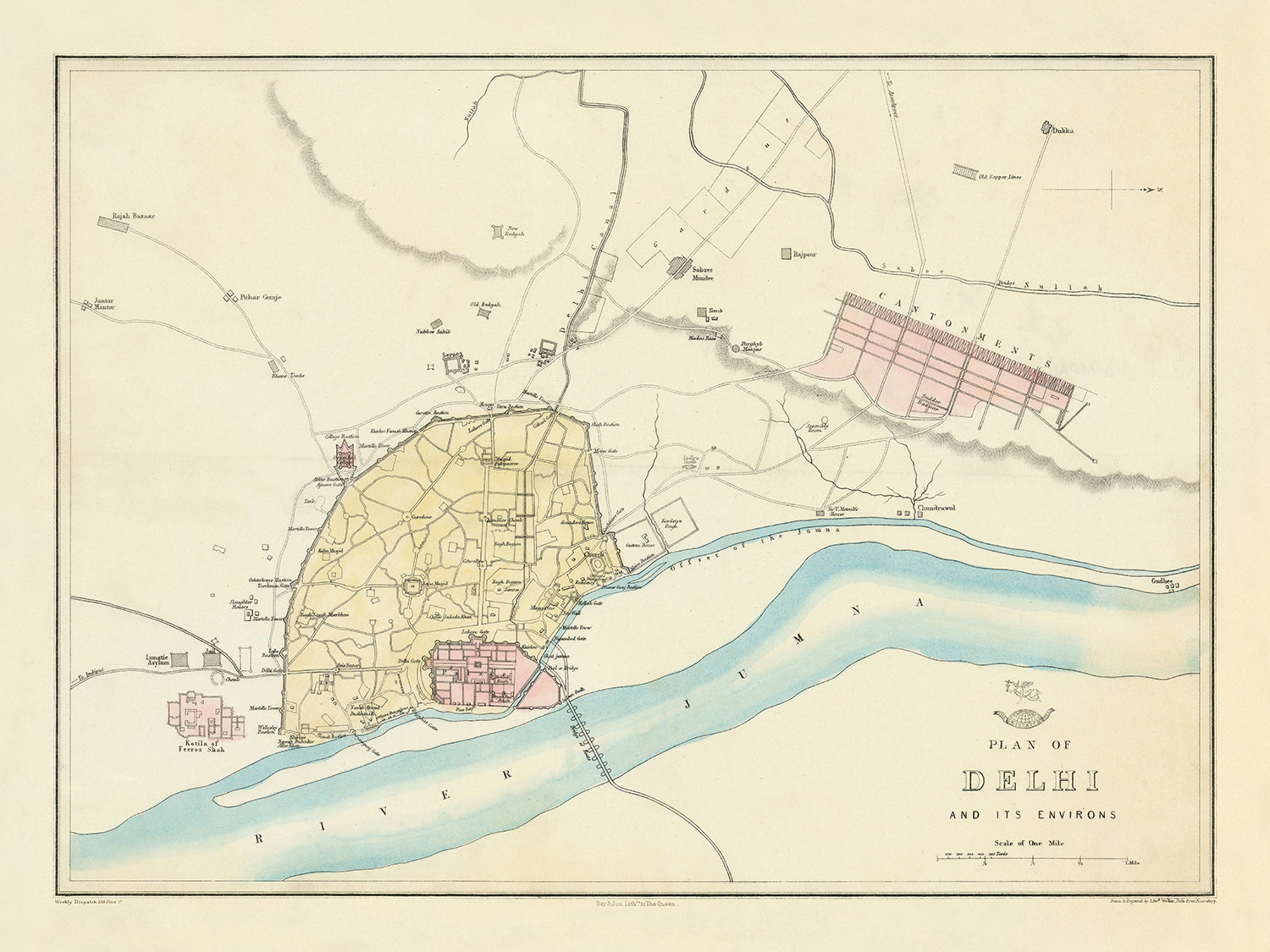


Mappa antica di Delhi di Weller, 1860: Jama Musjid, Il Palazzo, Ponte delle Barche, Cantoni, Fiume Jumna
Christmas Express Delivery
You can order up until 10am on December 22 with Express Delivery to receive your order by Christmas.
Unframed products are much more likely to arrive by Christmas. Framed products may arrive on time, but they move more slowly, particularly when couriers are so overloaded with packages.
Personalised orders are unlikely to arrive on time (but if you absolutely must have a personalised product, please contact me and I'll do my best to help!)
Contact me for info on last-minute deliveries.
Spend £250, Save £50 Christmas Express Delivery available
Christmas Express Delivery
You can order up until 10am on December 22 with Express Delivery to receive your order by Christmas.
Unframed products are much more likely to arrive by Christmas. Framed products may arrive on time, but they move more slowly, particularly when couriers are so overloaded with packages.
Personalised orders are unlikely to arrive on time (but if you absolutely must have a personalised product, please contact me and I'll do my best to help!)
Contact me for info on last-minute deliveries.
Spend £250, Save £50

-
![]() Handmade in the UK (we're based in London)
Handmade in the UK (we're based in London)
-
FREE delivery in 3-4 days ⓘ
Free delivery in 3-4 days
Your map should be delivered in 3-4 working days with free delivery, worldwide.
Please use Express Delivery at checkout for Christmas orders. Framed orders may arrive with Express Delivery, but it is not guaranteed.
New for 2025: After you order, you can send a beautiful gift preview by email, if you're worried it won't arrive on time.
We make maps by hand locally in 23 countries. If you're buying a gift for someone in another country, we will make the map locally to them.
You will never pay import tax or customs duty.
Check the Christmas delivery guide for order deadlines. Delivery times are starting to slow down, and will continue to slow down towards Christmas.
Express delivery is available at checkout which can reduce the delivery time to 1-2 days.
Please note that personalised maps, and larger framed maps, can take longer to produce and deliver.
If you need your order to arrive by a certain date, contact me and we can discuss your options.
-
FREE gift preview
ⓘ
Digital gift preview
New for 2025: After you complete your order, you can send a beautiful digital preview to the gift recipient. Just provide their email address and we'll do the rest. (Their email address will not be stored or used for any other purpose.)
This is perfect for Christmas gifting, particularly if you're concerned that your order might not arrive in time for Christmas.
-
90 day money back guarantee
ⓘ
90 giorni per restituire e ricevere un rimborso
I prodotti possono essere restituiti entro 90 giorni per un rimborso completo, o cambio con un altro prodotto.
Per articoli personalizzati e su misura, potremmo offrirti un credito in negozio o una carta regalo non scadente, poiché non possiamo rivendere ordini personalizzati.
Se hai domande, contattaci. Per ulteriori informazioni, consulta la nostra politica di restituzione e cambio.

My maps are rare, museum-grade, restored old maps sourced from libraries, auction houses and private collections across the globe.
Framing & free personalisation available
1. Select your size
2. Frame & personalise your map
There is limited framing & personalisation capacity available. Order by 10am tomorrow for Christmas delivery.


Gift message & custom finish

If you want to add a gift message, or a finish (jigsaw, aluminium board, etc.) that is not available here, please request it in the "order note" when you check out.
Every order is custom made, so if you need the size adjusted slightly, or printed on an unusual material, just let us know. We've done thousands of custom orders over the years, so there's (almost) nothing we can't manage.
You can also contact us before you order, if you prefer!

- Handmade locally. No import duty or tax
- FREE Delivery by Christmas
- Love it or your money back (90 days)
- Questions? WhatsApp me any time
Own a piece of history
5,000+ 5 star reviews


Il "Piano di Delhi e dei suoi Dintorni," realizzato da Edward Weller nel 1860, offre uno sguardo affascinante sul tessuto urbano di Delhi durante il periodo coloniale britannico. Questa mappa della città, meticolosamente incisa, è un pezzo raro dell' 'Atlante del Weekly Dispatch,' una serie rinomata per le sue rappresentazioni cartografiche dettagliate. La mappa cattura vividamente la disposizione di Delhi, evidenziando i luoghi significativi e i quartieri che hanno definito la città a metà del XIX secolo. Funziona sia come documento storico che come opera d'arte, riflettendo la complessità della pianificazione urbana e la grandezza architettonica dell'epoca.
Una delle caratteristiche più sorprendenti di questa mappa è la sua dettagliata rappresentazione dei principali luoghi di interesse di Delhi. La Jama Musjid, una moschea monumentale, spicca come punto focale, insieme al maestoso Palazzo e al famoso Ponte delle Barche. Questi luoghi non sono solo punti di interesse, ma sono impregnati di significato storico e culturale, offrendo spunti sulle priorità architettoniche e sociali dell'epoca. L'inclusione di istituzioni educative come il Collegio Orientale sottolinea ulteriormente il ruolo della città come centro di apprendimento e cultura.
La mappa delinea anche vari quartieri, ognuno con il proprio carattere unico e contesto storico. I Cantoni, evidenziati in rosa, riflettono la presenza militare britannica, mentre aree come Rajpore e Subzee Mundee offrono uno sguardo sulle zone residenziali e commerciali locali. Questi quartieri, con le loro disposizioni e funzioni distinte, dipingono un quadro vivido della vita diversificata e vibrante a Delhi. La rappresentazione accurata di queste aree rende la mappa una risorsa inestimabile per comprendere la geografia storica della città.
Il fiume Jumna, che scorre graziosamente attraverso la mappa, aggiunge un elemento naturale al paesaggio urbano. Questo fiume è stato una linfa vitale per Delhi, plasmando il suo sviluppo e fungendo da risorsa critica per i suoi abitanti. La mappa presenta anche grandi parchi come Kudsia Bagh, che fornivano spazi verdi per il divertimento e il riposo in mezzo alla frenetica città. Queste caratteristiche naturali non sono semplicemente decorative, ma sono parte integrante della storia e dello sviluppo della città, riflettendo l'interazione tra urbanizzazione e natura.
La maestria di Edward Weller è evidente nell'incisione precisa della mappa e nell'inclusione di numerosi dettagli che danno vita alla città. Il suo lavoro, insieme a quello di altri incisori come John Dower, ha contribuito all' 'Atlante del Weekly Dispatch,' un progetto cartografico significativo del XIX secolo. Questa mappa non è solo una rappresentazione di Delhi, ma un testamento all'abilità di Weller e al contesto storico più ampio della cartografia britannica. Si erge come un artefatto notevole, offrendo una finestra sul passato e una più profonda apprezzamento del ricco patrimonio di Delhi.
Strade e percorsi su questa mappa
- Nessuna delle strade o dei percorsi su questa mappa è etichettata.
Caratteristiche e Luoghi Notabili
- Luoghi:
- Jama Musjid
- Il Palazzo
- Ponte delle Barche
- Collegio Orientale
- Fortificazioni
- Vecchio Palazzo Rajput
- Sabz Burj
- Kotwalee
- Jumma Musjid
- Kotee di Roshun-ud-Dowlah
- Osservatorio
- Tomba di Humayoon
- Vecchia Fortezza
- Lall Diggee
- L'Osservatorio
- Metcalfe House
- Kudsia Bagh
- Magazzino
- Torre del Flag Staff
- Ridge
- Quartieri:
- Cantoni (evidenziati in rosa)
- Rajpore
- Subzee Mundee
- Pahar Gunje
- Bazar Jutwarra
- Kishengunge
- Kishen Gunge
- Darya Gunge
- Grandi Parchi:
- Kudsia Bagh
- Altre caratteristiche notevoli:
- Fiume Jumna
- Linee ferroviarie e stazioni
Contesto storico e di design
- Nome della mappa: Piano di Delhi e dei suoi dintorni
- Data di creazione: 1860
- Cartografo/Editore: Edward Weller
- Contesto sul cartografo: Edward Weller è stato uno degli incisori per le mappe incluse nell' 'Atlas Weekly Dispatch'. Il giornale 'Weekly Dispatch' includeva mappe in ogni edizione dal 1856 al 1862. Queste mappe furono successivamente raccolte nell' 'Atlas Dispatch' nel 1863 e combinate con mappe delle contee inglesi nel 1865 come 'Cassell's Complete Atlas'.
- Argomenti e temi:
- Mappa stradale della città: La mappa si concentra sulla disposizione e sui principali punti di riferimento di Delhi.
- Contesto storico: Questa mappa è stata creata durante il periodo coloniale britannico in India, fornendo uno sguardo sulla pianificazione urbana e sui punti di riferimento significativi di Delhi in quel periodo.
- Paesi e regioni mostrati: La mappa si concentra su Delhi, India.
- Design/Stile:
- Incisione: La mappa è un'opera incisa, una tecnica comune nel XIX secolo.
- Segno distintivo: La mappa porta il segno distintivo di un mezzo globo con la figura di Mercurio sopra, a segnare la sua inclusione nell' 'Atlas Weekly Dispatch'.
- Significato storico:
- Disposizione urbana: La mappa fornisce preziose informazioni storiche sulla disposizione urbana e sulle strutture significative di Delhi durante la metà del XIX secolo.
- Era coloniale: Riflette l'influenza coloniale britannica sulla rappresentazione cartografica delle città indiane.
Si prega di controllare attentamente le immagini per assicurarsi che una specifica città o luogo sia mostrato su questa mappa. È possibile anche contattarci e chiedere di controllare la mappa per voi.
Questa mappa appare fantastica in ogni dimensione, ma consiglio sempre di optare per una dimensione più grande se avete spazio. In questo modo potete facilmente distinguere tutti i dettagli.
Questa mappa appare incredibile in dimensioni fino a 70in (180cm). Se state cercando una mappa più grande, per favore contattateci.
Si prega di notare: le etichette su questa mappa sono difficili da leggere se ordinate una mappa che è 16in (40cm) o più piccola. La mappa è comunque molto attraente, ma se desiderate leggere la mappa facilmente, vi preghiamo di acquistare una dimensione più grande.
Il modello nelle immagini dell'elenco tiene la versione della mappa 18x24in (45x60cm).
La quinta immagine dell'elenco mostra un esempio del mio servizio di personalizzazione della mappa.
Se state cercando qualcosa di leggermente diverso, date un'occhiata alla mia collezione delle migliori mappe antiche per vedere se qualcosa attira la vostra attenzione.
Per favore contattatemi per verificare se una certa posizione, punto di riferimento o caratteristica è mostrata su questa mappa.
Questo sarebbe un meraviglioso regalo di compleanno, Natale, Festa del Papà, partenza dal lavoro, anniversario o regalo per la nuova casa per qualcuno delle aree coperte da questa mappa.
Questa mappa è disponibile come stampa giclée su carta opaca archiviabile priva di acidi, oppure puoi acquistarla incorniciata. La cornice è una semplice cornice nera che si adatta alla maggior parte degli stili. Ti preghiamo di contattarci se desideri un colore o un materiale diverso per la cornice. Le mie cornici sono dotate di un vetro acrilico super chiaro di grado museale (perspex/acrylite), che è significativamente meno riflettente del vetro, più sicuro e arriverà sempre in perfette condizioni.
This map is also available as a float framed canvas, sometimes known as a shadow gap framed canvas or canvas floater. The map is printed on artist's cotton canvas and then stretched over a handmade box frame. We then "float" the canvas inside a wooden frame, which is available in a range of colours (black, dark brown, oak, antique gold and white). This is a wonderful way to present a map without glazing in front. See some examples of float framed canvas maps and explore the differences between my different finishes.
For something truly unique, this map is also available in "Unique 3D", our trademarked process that dramatically transforms the map so that it has a wonderful sense of depth. We combine the original map with detailed topography and elevation data, so that mountains and the terrain really "pop". For more info and examples of 3D maps, check my Unique 3D page.
For most orders, delivery time is about 3 working days. Personalised and customised products take longer, as I have to do the personalisation and send it to you for approval, which usually takes 1 or 2 days.
Please note that very large framed orders usually take longer to make and deliver.
If you need your order to arrive by a certain date, please contact me before you order so that we can find the best way of making sure you get your order in time.
I print and frame maps and artwork in 23 countries around the world. This means your order will be made locally, which cuts down on delivery time and ensures that it won't be damaged during delivery. You'll never pay customs or import duty, and we'll put less CO2 into the air.
All of my maps and art prints are well packaged and sent in a rugged tube if unframed, or surrounded by foam if framed.
I try to send out all orders within 1 or 2 days of receiving your order, though some products (like face masks, mugs and tote bags) can take longer to make.
If you select Express Delivery at checkout your order we will prioritise your order and send it out by 1-day courier (Fedex, DHL, UPS, Parcelforce).
Next Day delivery is also available in some countries (US, UK, Singapore, UAE) but please try to order early in the day so that we can get it sent out on time.
My standard frame is a gallery style black ash hardwood frame. It is simple and quite modern looking. My standard frame is around 20mm (0.8in) wide.
I use super-clear acrylic (perspex/acrylite) for the frame glass. It's lighter and safer than glass - and it looks better, as the reflectivity is lower.
Six standard frame colours are available for free (black, dark brown, dark grey, oak, white and antique gold). Custom framing and mounting/matting is available if you're looking for something else.
Most maps, art and illustrations are also available as a framed canvas. We use matte (not shiny) cotton canvas, stretch it over a sustainably sourced box wood frame, and then 'float' the piece within a wood frame. The end result is quite beautiful, and there's no glazing to get in the way.
All frames are provided "ready to hang", with either a string or brackets on the back. Very large frames will have heavy duty hanging plates and/or a mounting baton. If you have any questions, please get in touch.
See some examples of my framed maps and framed canvas maps.
Alternatively, I can also supply old maps and artwork on canvas, foam board, cotton rag and other materials.
If you want to frame your map or artwork yourself, please read my size guide first.
Alcune delle mie vecchie mappe sono ora disponibili come tele incorniciate. Per favore contattami se desideri ordinare una dimensione che non è disponibile nel mio negozio.
Le vecchie mappe su tela sono un'alternativa interessante alle mappe incorniciate in modo convenzionale. A seconda del tuo gusto personale e dell'arredamento della stanza, le mappe su tela possono "risaltare" un po' di più rispetto a una mappa incorniciata.
My maps are extremely high quality reproductions of original maps.
I source original, rare maps from libraries, auction houses and private collections around the world, restore them at my London workshop, and then use specialist giclée inks and printers to create beautiful maps that look even better than the original.
My maps are printed on acid-free archival matte (not glossy) paper that feels very high quality and almost like card. In technical terms the paper weight/thickness is 10mil/200gsm. It's perfect for framing.
I print with Epson ultrachrome giclée UV fade resistant pigment inks - some of the best inks you can find.
I can also make maps on canvas, cotton rag and other exotic materials.
Learn more about The Unique Maps Co.
Map personalisation
If you're looking for the perfect anniversary or housewarming gift, I can personalise your map to make it truly unique. For example, I can add a short message, or highlight an important location, or add your family's coat of arms.
The options are almost infinite. Please see my map personalisation page for some wonderful examples of what's possible.
To order a personalised map, select "personalise your map" before adding it to your basket.
Get in touch if you're looking for more complex customisations and personalisations.
Map ageing
I have been asked hundreds of times over the years by customers if they could buy a map that looks even older.
Well, now you can, by selecting Aged before you add a map to your basket.
All the product photos you see on this page show the map in its Original form. This is what the map looks like today.
If you select Aged, I will age your map by hand, using a special and unique process developed through years of studying old maps, talking to researchers to understand the chemistry of aging paper, and of course... lots of practice!
If you're unsure, stick to the Original colour of the map. If you want something a bit darker and older looking, go for Aged.
Se non sei soddisfatto del tuo ordine per qualsiasi motivo, contattami per un rimborso senza problemi. Si prega di consultare la nostra politica di reso e rimborso per ulteriori informazioni.
Sono molto sicuro che ti piacerà la tua mappa restaurata o la stampa d'arte. Lo faccio dal 1984. Sono un venditore Etsy a 5 stelle. Ho venduto decine di migliaia di mappe e stampe d'arte e ho oltre 5.000 recensioni reali a 5 stelle.
Utilizzo un processo unico per restaurare mappe e opere d'arte che richiede molto tempo e lavoro. Trovare le mappe e le illustrazioni originali può richiedere mesi. Utilizzo tecnologia all'avanguardia e incredibilmente costosa per scannerizzare e restaurarle. Di conseguenza, garantisco che le mie mappe e stampe d'arte siano superiori alle altre - ecco perché posso offrire un rimborso senza problemi.
Quasi tutte le mie mappe e stampe d'arte sembrano fantastiche a grandi dimensioni (200 cm, 6,5 piedi+) e posso anche incorniciarle e consegnarle a te, tramite un corriere speciale per oggetti di grandi dimensioni. Contattami per discutere delle tue esigenze specifiche.
Or try searching for something!


