


Mapa raro del Renacimiento de la Península Arábiga por Berlinghieri y Ptolomeo, 1482: Arabia Saudita, EAU, Catar, Omán
La oferta del coleccionista
Elija dos obras elegibles y obtenga un 20 % de descuento en ambas. Elija tres y la de menor precio será gratuita, con un ahorro máximo del 33 %.
Combine y mezcle mapas estándar elegibles y reproducciones de bellas artes. No se requiere código; la oferta se aplica automáticamente al finalizar la compra.
Se incluyen las configuraciones estándar hechas por encargo. Quedan excluidos los tamaños a medida, los diseños personalizados y los trabajos por encargo.
¿Necesita entrega en diferentes direcciones? Contáctenos antes de realizar el pedido.La oferta del coleccionista
Elija dos obras elegibles y obtenga un 20 % de descuento en ambas. Elija tres y la de menor precio será gratuita, con un ahorro máximo del 33 %.
Combine y mezcle mapas estándar elegibles y reproducciones de bellas artes. No se requiere código; la oferta se aplica automáticamente al finalizar la compra.
Se incluyen las configuraciones estándar hechas por encargo. Quedan excluidos los tamaños a medida, los diseños personalizados y los trabajos por encargo.
¿Necesita entrega en diferentes direcciones? Contáctenos antes de realizar el pedido. Restaurado en Londres • Hecho en the UK

Restaurado a partir del mapa original de 1482 e impreso en calidad museo. Leer la historia detrás de este mapa
Choose your size
Choose your finish


(Más información)
Mensaje de regalo y acabado personalizado

Si deseas agregar un mensaje de regalo, o un acabado (rompecabezas, tablero de aluminio, etc.) que no esté disponible aquí, por favor solicítalo en la "nota del pedido" cuando realices la compra.
Cada pedido es hecho a medida, así que si necesitas que el tamaño se ajuste ligeramente, o que se imprima en un material inusual, háznoslo saber. Hemos realizado miles de pedidos personalizados a lo largo de los años, así que hay (casi) nada que no podamos gestionar.
También puedes contactarnos antes de hacer tu pedido, ¡si lo prefieres!

- Hecho localmente. Entrega segura
- Sin aranceles ni cargos ocultos
- ¿Necesitas ayuda? Llámanos o mensaje por WhatsApp
Own a piece of history
8,000+ five-star reviews


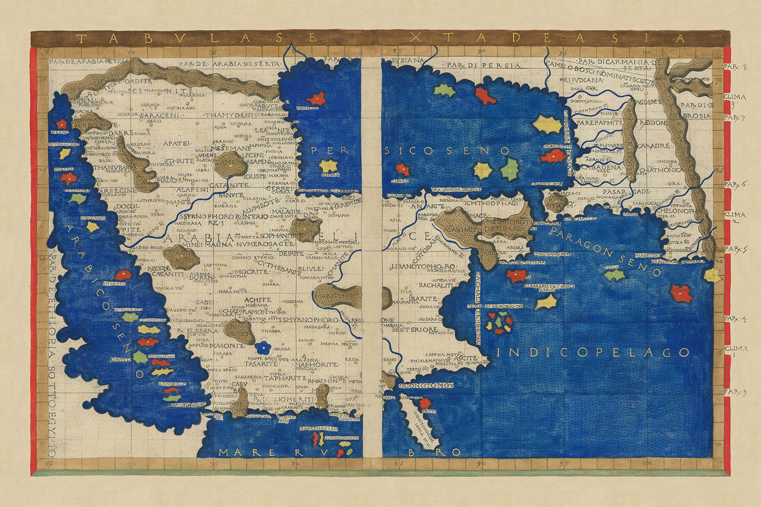
Adéntrese en el mundo del descubrimiento renacentista con la extraordinaria Tabula Sexta de Asia (Península Arábiga), una obra maestra de la cartografía...
Seguir leyendoAdéntrese en el mundo del descubrimiento renacentista con la extraordinaria Tabula Sexta de Asia (Península Arábiga), una obra maestra de la cartografía temprana impresa por primera vez en Florencia en 1482. Este mapa raro y evocador es la creación de Francesco Berlinghieri, un innovador florentino cuyo enfoque audaz redefinió los límites del conocimiento geográfico. Basándose en la antigua sabiduría de Claudio Ptolomeo y complementándola con fuentes contemporáneas, el mapa de Berlinghieri se destaca como un vívido testimonio de la curiosidad y ambición de la época. La Tabula Sexta de Asia es más que un registro geográfico; es una narrativa visual que captura la imaginación de exploradores y eruditos por igual mientras buscaban entender la vasta y misteriosa Península Arábiga.
La visión de Berlinghieri era tanto académica como artística. A diferencia de sus contemporáneos, imbuyó sus mapas con costas dinámicas y cordilleras fluidas, reflejando un mundo vivo con movimiento y posibilidad. La Península Arábiga emerge aquí en una forma distintivamente ptolomeica, sus contornos estirados y moldeados por las limitaciones y aspiraciones del conocimiento clásico. Sin embargo, dentro de este marco, el arte de Berlinghieri brilla: los ríos serpentean desde los macizos centrales hacia costas distantes, los archipiélagos se agrupan cerca del estrecho de Ormuz, y las costas del Mar Rojo y del Golfo Pérsico undulan con una gracia casi pictórica. Este es un mapa donde el mito y la realidad se entrelazan, donde el mundo conocido se encuentra con lo legendario.
Entre las características más cautivadoras del mapa están sus representaciones de las Ciudades Santas—La Meca (Macoraba) y Medina (Lathrippa)—situadas entre montañas y ríos estilizados, cuyas posiciones insinúan la profunda significación religiosa y comercial que tuvieron incluso en la antigüedad. A lo largo del Mar Rojo, el bullicioso puerto de Yeda (Badeo Regio) y el puerto norteño de Yanbu se representan con notable fidelidad, mientras que el interior legendario, el Rub al-Khali o Cuarto Vacío, está imaginativamente lleno de pueblos, ríos y cordilleras conjecturales. Aquí, los límites entre el hecho y la leyenda se difuminan, resonando con las historias y especulaciones de marineros y comerciantes que bordeaban el corazón inexplorado de Arabia.
Las regiones orientales del mapa ofrecen una temprana y tentadora visión de áreas que se convertirían en el moderno Catar y los Emiratos Árabes Unidos. Topónimos antiguos como Catara y Chabuata se erigen como algunas de las primeras representaciones cartográficas de estos ahora vitales centros, mientras que las distintivas hendiduras y bahías de la costa evocan la dinámica interacción entre tierra y mar. La inclusión de islas como Socotra y archipiélagos intrincados cerca del estrecho de Ormuz subraya aún más el compromiso de Berlinghieri de capturar tanto la geografía física como la mitológica del mundo árabe.
El legado de Francesco Berlinghieri es el de un pionero cartográfico—uno que se atrevió a desafiar la convención al combinar el rigor matemático de Ptolomeo con las sensibilidades artísticas del Renacimiento florentino. Su Tabula Sexta de Asia es un logro singular, notable no solo por su significancia histórica sino también por su belleza perdurable. Poseer este mapa es poseer una pieza del fermento intelectual y artístico que moldeó la comprensión moderna del mundo—una ventana rara a la imaginación y ambición del Renacimiento, donde cada río, montaña y costa cuenta una historia que ha sido siglos en la elaboración.
Ciudades y pueblos en este mapa
- Arabia Saudita
- Yeda (Badeo Regio) – población moderna: ~4.7 millones
- La Meca (Macoraba) – población moderna: ~2 millones
- Medina (Lathrippa/Yathrib) – población moderna: ~1.5 millones
- Najran (Nagara) – población moderna: ~600,000
- Al-Qatif (Magidanata, aunque mal ubicado en el mapa) – población moderna: ~500,000
-
Yanbu (Iabia-Vie/Iambia) – población moderna: ~250,000
-
Emiratos Árabes Unidos
- Abu Dabi (Chabuata) – población moderna: ~1.5 millones
- Sharjah (Sacoa) – población moderna: ~1.3 millones
-
Jazīrat as Sīnīyah (Casina) – población: pequeña, parte de Umm Al Quwain
-
Qatar
-
Catara (región de Qatar/Doha) – población moderna: Doha ~2.4 millones
-
Omán
- Bidbid (Vodona, mal ubicado en el centro del mapa) – población moderna: ~20,000
-
Nizwa (cerca de Bidbid) – población moderna: ~70,000
-
Yemen
- Najran (Nagara, en realidad en Arabia Saudita pero a menudo asociado con Yemen en fuentes antiguas)
Características y lugares notables
- Mar Rojo (Mare Rubrum)
- Golfo Pérsico (Sinus Persicus)
- Mar Arábigo (Mare Erythraeum)
- Golfo de Adén (representado)
- Alar Fl. (posiblemente Wadi Lamhah)
- Betio Fl. (corresponde a Wadi Fa’idah o Wadi Fayd)
- Prion Fl. (mitológico, posiblemente el río Pishon)
- Macizo central/cordilleras representadas en forma estilizada
- Cadenas montañosas que atraviesan la península
- Socotra (gran isla al sur de Arabia)
- Cadena de islas en el Mar Rojo
- Características similares a un archipiélago cerca del Estrecho de Ormuz
- Regiones etiquetadas: Arabia Félix, Arabia Petrea, Arabia Deserta
- “SARACENI” etiquetado en el desierto del norte
- Costas dinámicas y estilizadas con bahías y ensenadas, especialmente a lo largo del Golfo y el Mar Rojo
Contexto histórico y de diseño
- Título original: (Península Arábiga) Tabula Sexta de Asia
- Creado por Francesco Berlinghieri en Florencia, 1482, basado en el trabajo de Claudio Ptolomeo
- Entre los primeros mapas impresos que representan la Península Arábiga en una forma reconocible
- Parte del atlas innovador de Berlinghieri Septe Giornate della Geographia, notable por usar múltiples proyecciones cartográficas y fuentes más allá de Ptolomeo
- Mapa artístico con costas dinámicas, cordilleras fluidas y ríos estilizados
- Llena el interior árabe (Cuarto Vacío/Rub al-Khali) con características conjeturales y mitológicas, reflejando el conocimiento limitado de la región en ese momento
- Muestra tanto características antiguas como mitológicas, incluyendo las primeras representaciones tenues de Qatar y los Emiratos Árabes Unidos
- Mezcla conocimiento clásico, leyenda medieval e innovación renacentista
- El “primer estado” del mapa, confirmado por características textuales específicas (“PAR DE ARABIA PETREA” y “SARACENI” sin sobreimpresión)
- Importante para el estudio de la cartografía temprana y la transmisión del conocimiento geográfico desde la antigüedad hasta el Renacimiento
Por favor, verifique las imágenes para asegurarse de que una ciudad o lugar específico se muestra en este mapa. También puede ponerse en contacto y pedirnos que verifiquemos el mapa por usted.
Este mapa se ve genial en cualquier tamaño, pero siempre recomiendo optar por un tamaño más grande si tiene espacio. De esa manera, puede distinguir fácilmente todos los detalles.
Este mapa se ve increíble en tamaños de hasta 90in (230cm). Si estás buscando un mapa más grande, por favor ponte en contacto.
El modelo en las imágenes del anuncio está sosteniendo la versión de 24x36in (60x90cm) de este mapa.
La quinta imagen del anuncio muestra un ejemplo de mi servicio de personalización de mapas.
Si estás buscando algo ligeramente diferente, echa un vistazo a mi colección de los mejores mapas antiguos para ver si algo más llama tu atención.
Por favor contáctame para verificar si una ubicación, hito o característica específica está mostrada en este mapa.
Este sería un regalo maravilloso para un cumpleaños, Navidad, Día del Padre, despedida de trabajo, aniversario o inauguración de casa para alguien de las áreas cubiertas por este mapa.
Este mapa está disponible como una impresión giclée en papel mate libre de ácido y de archivo, o puedes comprarlo enmarcado. El marco es un bonito y simple marco negro que se adapta a la mayoría de las estéticas. Por favor, ponte en contacto si te gustaría un color o material de marco diferente. Mis marcos están envidriados con acrílico de museo superclaro (perspex/acrylite), que es significativamente menos reflectante que el vidrio, más seguro y siempre llegará en perfectas condiciones.
This map is also available as a float framed canvas, sometimes known as a shadow gap framed canvas or canvas floater. The map is printed on artist's cotton canvas and then stretched over a handmade box frame. We then "float" the canvas inside a wooden frame, which is available in a range of colours (black, dark brown, oak, antique gold and white). This is a wonderful way to present a map without glazing in front. See some examples of float framed canvas maps and explore the differences between my different finishes.
For something truly unique, this map is also available in "Unique 3D", our trademarked process that dramatically transforms the map so that it has a wonderful sense of depth. We combine the original map with detailed topography and elevation data, so that mountains and the terrain really "pop". For more info and examples of 3D maps, check my Unique 3D page.
Adéntrese en el mundo del descubrimiento renacentista con la extraordinaria Tabula Sexta de Asia (Península Arábiga), una obra maestra de la cartografía temprana impresa por primera vez en Florencia en 1482. Este mapa raro y evocador es la creación de Francesco Berlinghieri, un innovador florentino cuyo enfoque audaz redefinió los límites del conocimiento geográfico. Basándose en la antigua sabiduría de Claudio Ptolomeo y complementándola con fuentes contemporáneas, el mapa de Berlinghieri se destaca como un vívido testimonio de la curiosidad y ambición de la época. La Tabula Sexta de Asia es más que un registro geográfico; es una narrativa visual que captura la imaginación de exploradores y eruditos por igual mientras buscaban entender la vasta y misteriosa Península Arábiga.
La visión de Berlinghieri era tanto académica como artística. A diferencia de sus contemporáneos, imbuyó sus mapas con costas dinámicas y cordilleras fluidas, reflejando un mundo vivo con movimiento y posibilidad. La Península Arábiga emerge aquí en una forma distintivamente ptolomeica, sus contornos estirados y moldeados por las limitaciones y aspiraciones del conocimiento clásico. Sin embargo, dentro de este marco, el arte de Berlinghieri brilla: los ríos serpentean desde los macizos centrales hacia costas distantes, los archipiélagos se agrupan cerca del estrecho de Ormuz, y las costas del Mar Rojo y del Golfo Pérsico undulan con una gracia casi pictórica. Este es un mapa donde el mito y la realidad se entrelazan, donde el mundo conocido se encuentra con lo legendario.
Entre las características más cautivadoras del mapa están sus representaciones de las Ciudades Santas—La Meca (Macoraba) y Medina (Lathrippa)—situadas entre montañas y ríos estilizados, cuyas posiciones insinúan la profunda significación religiosa y comercial que tuvieron incluso en la antigüedad. A lo largo del Mar Rojo, el bullicioso puerto de Yeda (Badeo Regio) y el puerto norteño de Yanbu se representan con notable fidelidad, mientras que el interior legendario, el Rub al-Khali o Cuarto Vacío, está imaginativamente lleno de pueblos, ríos y cordilleras conjecturales. Aquí, los límites entre el hecho y la leyenda se difuminan, resonando con las historias y especulaciones de marineros y comerciantes que bordeaban el corazón inexplorado de Arabia.
Las regiones orientales del mapa ofrecen una temprana y tentadora visión de áreas que se convertirían en el moderno Catar y los Emiratos Árabes Unidos. Topónimos antiguos como Catara y Chabuata se erigen como algunas de las primeras representaciones cartográficas de estos ahora vitales centros, mientras que las distintivas hendiduras y bahías de la costa evocan la dinámica interacción entre tierra y mar. La inclusión de islas como Socotra y archipiélagos intrincados cerca del estrecho de Ormuz subraya aún más el compromiso de Berlinghieri de capturar tanto la geografía física como la mitológica del mundo árabe.
El legado de Francesco Berlinghieri es el de un pionero cartográfico—uno que se atrevió a desafiar la convención al combinar el rigor matemático de Ptolomeo con las sensibilidades artísticas del Renacimiento florentino. Su Tabula Sexta de Asia es un logro singular, notable no solo por su significancia histórica sino también por su belleza perdurable. Poseer este mapa es poseer una pieza del fermento intelectual y artístico que moldeó la comprensión moderna del mundo—una ventana rara a la imaginación y ambición del Renacimiento, donde cada río, montaña y costa cuenta una historia que ha sido siglos en la elaboración.
Ciudades y pueblos en este mapa
- Arabia Saudita
- Yeda (Badeo Regio) – población moderna: ~4.7 millones
- La Meca (Macoraba) – población moderna: ~2 millones
- Medina (Lathrippa/Yathrib) – población moderna: ~1.5 millones
- Najran (Nagara) – población moderna: ~600,000
- Al-Qatif (Magidanata, aunque mal ubicado en el mapa) – población moderna: ~500,000
-
Yanbu (Iabia-Vie/Iambia) – población moderna: ~250,000
-
Emiratos Árabes Unidos
- Abu Dabi (Chabuata) – población moderna: ~1.5 millones
- Sharjah (Sacoa) – población moderna: ~1.3 millones
-
Jazīrat as Sīnīyah (Casina) – población: pequeña, parte de Umm Al Quwain
-
Qatar
-
Catara (región de Qatar/Doha) – población moderna: Doha ~2.4 millones
-
Omán
- Bidbid (Vodona, mal ubicado en el centro del mapa) – población moderna: ~20,000
-
Nizwa (cerca de Bidbid) – población moderna: ~70,000
-
Yemen
- Najran (Nagara, en realidad en Arabia Saudita pero a menudo asociado con Yemen en fuentes antiguas)
Características y lugares notables
- Mar Rojo (Mare Rubrum)
- Golfo Pérsico (Sinus Persicus)
- Mar Arábigo (Mare Erythraeum)
- Golfo de Adén (representado)
- Alar Fl. (posiblemente Wadi Lamhah)
- Betio Fl. (corresponde a Wadi Fa’idah o Wadi Fayd)
- Prion Fl. (mitológico, posiblemente el río Pishon)
- Macizo central/cordilleras representadas en forma estilizada
- Cadenas montañosas que atraviesan la península
- Socotra (gran isla al sur de Arabia)
- Cadena de islas en el Mar Rojo
- Características similares a un archipiélago cerca del Estrecho de Ormuz
- Regiones etiquetadas: Arabia Félix, Arabia Petrea, Arabia Deserta
- “SARACENI” etiquetado en el desierto del norte
- Costas dinámicas y estilizadas con bahías y ensenadas, especialmente a lo largo del Golfo y el Mar Rojo
Contexto histórico y de diseño
- Título original: (Península Arábiga) Tabula Sexta de Asia
- Creado por Francesco Berlinghieri en Florencia, 1482, basado en el trabajo de Claudio Ptolomeo
- Entre los primeros mapas impresos que representan la Península Arábiga en una forma reconocible
- Parte del atlas innovador de Berlinghieri Septe Giornate della Geographia, notable por usar múltiples proyecciones cartográficas y fuentes más allá de Ptolomeo
- Mapa artístico con costas dinámicas, cordilleras fluidas y ríos estilizados
- Llena el interior árabe (Cuarto Vacío/Rub al-Khali) con características conjeturales y mitológicas, reflejando el conocimiento limitado de la región en ese momento
- Muestra tanto características antiguas como mitológicas, incluyendo las primeras representaciones tenues de Qatar y los Emiratos Árabes Unidos
- Mezcla conocimiento clásico, leyenda medieval e innovación renacentista
- El “primer estado” del mapa, confirmado por características textuales específicas (“PAR DE ARABIA PETREA” y “SARACENI” sin sobreimpresión)
- Importante para el estudio de la cartografía temprana y la transmisión del conocimiento geográfico desde la antigüedad hasta el Renacimiento
Por favor, verifique las imágenes para asegurarse de que una ciudad o lugar específico se muestra en este mapa. También puede ponerse en contacto y pedirnos que verifiquemos el mapa por usted.
Este mapa se ve genial en cualquier tamaño, pero siempre recomiendo optar por un tamaño más grande si tiene espacio. De esa manera, puede distinguir fácilmente todos los detalles.
Este mapa se ve increíble en tamaños de hasta 90in (230cm). Si estás buscando un mapa más grande, por favor ponte en contacto.
El modelo en las imágenes del anuncio está sosteniendo la versión de 24x36in (60x90cm) de este mapa.
La quinta imagen del anuncio muestra un ejemplo de mi servicio de personalización de mapas.
Si estás buscando algo ligeramente diferente, echa un vistazo a mi colección de los mejores mapas antiguos para ver si algo más llama tu atención.
Por favor contáctame para verificar si una ubicación, hito o característica específica está mostrada en este mapa.
Este sería un regalo maravilloso para un cumpleaños, Navidad, Día del Padre, despedida de trabajo, aniversario o inauguración de casa para alguien de las áreas cubiertas por este mapa.
Este mapa está disponible como una impresión giclée en papel mate libre de ácido y de archivo, o puedes comprarlo enmarcado. El marco es un bonito y simple marco negro que se adapta a la mayoría de las estéticas. Por favor, ponte en contacto si te gustaría un color o material de marco diferente. Mis marcos están envidriados con acrílico de museo superclaro (perspex/acrylite), que es significativamente menos reflectante que el vidrio, más seguro y siempre llegará en perfectas condiciones.
This map is also available as a float framed canvas, sometimes known as a shadow gap framed canvas or canvas floater. The map is printed on artist's cotton canvas and then stretched over a handmade box frame. We then "float" the canvas inside a wooden frame, which is available in a range of colours (black, dark brown, oak, antique gold and white). This is a wonderful way to present a map without glazing in front. See some examples of float framed canvas maps and explore the differences between my different finishes.
For something truly unique, this map is also available in "Unique 3D", our trademarked process that dramatically transforms the map so that it has a wonderful sense of depth. We combine the original map with detailed topography and elevation data, so that mountains and the terrain really "pop". For more info and examples of 3D maps, check my Unique 3D page.
Many of our maps and art prints are chosen as thoughtful gifts for homes, offices, studies and meaningful places.
Choose a framed option for the easiest ready-to-hang gift, or choose an unframed print if the recipient may prefer to select their own frame.
We make orders locally in 23 countries around the world, so gifts can often be produced close to the recipient. This helps them arrive faster, travel more safely, and avoid customs or import duty surprises.
- We can deliver directly to the recipient
- Framed pieces arrive ready to hang
- Unframed prints are carefully packed in a strong protective tube
- Almost every order is made locally, for faster, safer gifting
- 90-day returns give the recipient time to decide
If you are not sure what to choose, please contact us. We can help you pick the right map, size, finish or delivery option.
Para la mayoría de los pedidos, el tiempo de entrega es de aproximadamente 3 días laborables. Los productos personalizados y a medida tardan más, ya que tengo que hacer la personalización y enviártelo para su aprobación, lo cual suele tardar 1 o 2 días.
Tenga en cuenta que los pedidos enmarcados muy grandes suelen tardar más en fabricarse y entregarse.
Si necesitas que tu pedido llegue para una fecha determinada, por favor contáctame antes de hacer el pedido para que podamos encontrar la mejor manera de asegurarnos de que recibas tu pedido a tiempo.
Imprimo y enmarco mapas y obras de arte en 23 países alrededor del mundo. Esto significa que tu pedido se fabricará localmente, lo que reduce el tiempo de entrega y asegura que no se dañe durante el envío. Nunca pagarás aranceles de aduana o impuestos de importación, y pondremos menos CO2 en el aire.
Todos mis mapas y impresiones artísticas están bien empaquetados y enviados en un tubo resistente si no están enmarcados, o rodeados de espuma si están enmarcados.
Intento enviar todos los pedidos dentro de 1 o 2 días después de recibir tu pedido, aunque algunos productos (como mascarillas, tazas y bolsas de tela) pueden tardar más en fabricarse.
Si seleccionas Entrega Exprés al finalizar la compra, priorizaremos tu pedido y lo enviaremos por mensajería de 1 día (Fedex, DHL, UPS, Parcelforce).
La entrega al día siguiente también está disponible en algunos países (EE. UU., Reino Unido, Singapur, EAU), pero por favor intenta hacer tu pedido temprano en el día para que podamos enviarlo a tiempo.
Mi marco estándar es un marco de madera de fresno negro estilo galería. Es simple y tiene un aspecto bastante moderno. Mi marco estándar tiene alrededor de 20 mm (0.8 in) de ancho.
Utilizo acrílico super claro (perspex/acrylite) para el vidrio del marco. Es más ligero y seguro que el vidrio, y se ve mejor, ya que la reflectividad es menor.
Seis colores de marco estándar están disponibles de forma gratuita (negro, marrón oscuro, gris oscuro, roble, blanco y oro antiguo).El enmarcado y montaje/matizado personalizado está disponible si buscas algo diferente.
La mayoría de los mapas, arte e ilustraciones también están disponibles como un lienzo enmarcado. Utilizamos lienzo de algodón mate (no brillante), lo estiramos sobre un marco de madera de caja de origen sostenible, y luego 'flotamos' la pieza dentro de un marco de madera. El resultado final es bastante hermoso, y no hay cristal que se interponga.
Todos los marcos se proporcionan "listos para colgar", con una cuerda o soportes en la parte posterior. Los marcos muy grandes tendrán placas de colgar de alta resistencia y/o un listón de montaje. Si tienes alguna pregunta, por favor ponte en contacto.
Mira algunos ejemplos de mis mapas enmarcados y mapas en lienzo enmarcados.
Alternativamente, también puedo proporcionar mapas antiguos y obras de arte en lienzo, tablero de espuma, papel de algodón y otros materiales.
Si deseas enmarcar tu mapa o obra de arte tú mismo, por favor lee mi guía de tamaños primero.
Mis mapas son reproducciones de mapas originales de altísima calidad.
Obtengo mapas originales y raros de bibliotecas, casas de subastas y colecciones privadas de todo el mundo, los restauro en mi taller de Londres y luego uso tintas e impresoras giclée especializadas para crear hermosos mapas que lucen incluso mejor que el original.
Mis mapas están impresos en papel de archivo mate (no brillante) sin ácido que se siente de muy alta calidad y casi como una tarjeta. En términos técnicos, el peso/grosor del papel es de 10 mil/200 g/m². Es perfecto para enmarcar.
Imprimo con tintas pigmentadas Epson ultrachrome giclée UV resistentes a la decoloración, algunas de las mejores tintas que puedes encontrar.
yo también puedo hacer mapas sobre lienzo, trapo de algodón y otros materiales exóticos.
Obtenga más información sobre The Unique Maps Co..
Personalización de mapas
Si está buscando el regalo perfecto de aniversario o inauguración de la casa, puedo personalizar su mapa para hacerlo verdaderamente único. Por ejemplo, puedo agregar un mensaje corto, resaltar una ubicación importante o agregar el escudo de armas de su familia.
Las opciones son casi infinitas. Por favor mira mi página de personalización de mapas para ver algunos maravillosos ejemplos de lo que es posible.
Para pedir un mapa personalizado, seleccione "personalizar su mapa" antes de agregarlo a su carrito.
Ponerse en contacto si buscas personalizaciones y personalizaciones más complejas.
Envejecimiento del mapa
A lo largo de los años, los clientes me han preguntado cientos de veces si podían comprar un mapa que se viera uniforme. más viejo.
Bueno, ahora puedes hacerlo seleccionando Envejecido antes de agregar un mapa a tu carrito.
Todas las fotografías de productos que ve en esta página muestran el mapa en su forma original. Así es como se ve el mapa hoy.
Si selecciona Envejecido, envejeceré su mapa a mano, usando un proceso especial y único desarrollado a través de años de estudiar mapas antiguos, hablar con investigadores para comprender la química del envejecimiento del papel y, por supuesto... ¡mucha práctica!
Si no estás seguro, quédate con el color original del mapa. Si quieres algo un poco más oscuro y más viejo buscando, opte por Envejecido.
Si no estás satisfecho con tu pedido por cualquier motivo, contáctame para un reembolso sin complicaciones. Por favor, consulta nuestra política de devoluciones y reembolsos para más información.
Estoy muy seguro de que te gustará tu mapa o impresión artística restaurada. He estado haciendo esto desde 1984. Soy un vendedor de 5 estrellas en Etsy. He vendido decenas de miles de mapas e impresiones artísticas y tengo más de 5,000 opiniones reales de 5 estrellas.
Utilizo un proceso único para restaurar mapas y obras de arte que consume mucho tiempo y mano de obra. Buscar los mapas e ilustraciones originales puede llevar meses. Utilizo tecnología de última generación y extremadamente cara para escanear y restaurarlos. Como resultado, garantizo que mis mapas e impresiones artísticas son superiores a los demás - por eso puedo ofrecer un reembolso sin complicaciones.
Casi todos mis mapas e impresiones artísticas se ven increíbles en tamaños grandes (200cm, 6.5ft+) y también puedo enmarcarlos y entregártelos a través de un servicio de mensajería especial para tamaños grandes. Contáctame para discutir tus necesidades específicas.
Or try searching for something!


