


Raro mapa barroco de Escocia de Blome, 1670: Edimburgo, Glasgow, Highlands, ríos, Loch Ness
20% de descuento en 2 — 33% de descuento en 3
Añade dos artículos elegibles a tu carrito para recibir 20% de descuento. Añade un tercero y será complementario (equivalente a 33% de descuento al comprar tres).
No se necesita código — la oferta se aplica automáticamente al finalizar la compra.
Válido en todos los mapas estándar y impresiones de arte fino. Puedes mezclar y combinar cualquier diseño.
Si deseas enviar artículos a múltiples direcciones, por favor contáctanos antes de realizar tu pedido.
Las comisiones personalizadas y a medida están excluidas.
Contáctanos si tienes alguna pregunta
 Diseñado en Londres Hecho en the UK
Diseñado en Londres • Hecho en the UK
Diseñado en Londres Hecho en the UK
Diseñado en Londres • Hecho en the UK

Restaurado a partir del mapa original de 1670 e impreso en calidad museo. Descripción completa abajo.
Choose your size
Choose your finish


(Más información)
Mensaje de regalo y acabado personalizado

Si deseas agregar un mensaje de regalo, o un acabado (rompecabezas, tablero de aluminio, etc.) que no esté disponible aquí, por favor solicítalo en la "nota del pedido" cuando realices la compra.
Cada pedido es hecho a medida, así que si necesitas que el tamaño se ajuste ligeramente, o que se imprima en un material inusual, háznoslo saber. Hemos realizado miles de pedidos personalizados a lo largo de los años, así que hay (casi) nada que no podamos gestionar.
También puedes contactarnos antes de hacer tu pedido, ¡si lo prefieres!

- Hecho localmente. Entrega segura
- Sin aranceles ni cargos ocultos
- ¿Necesitas ayuda? Llámanos o mensaje por WhatsApp
Own a piece of history
8,000+ five-star reviews


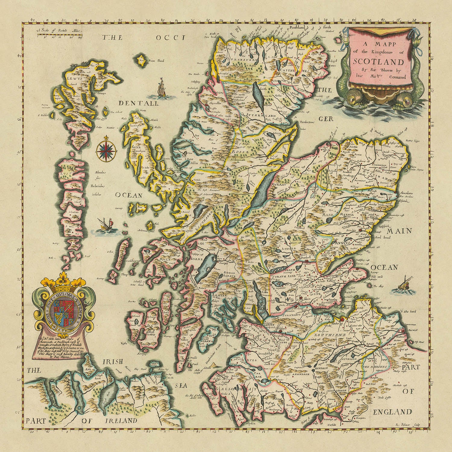
Sumérjase en el rico tapiz de la Escocia del siglo XVII con la magistral “A Mapp of the Kingdome of Scotland by...
Read the full product descriptionSumérjase en el rico tapiz de la Escocia del siglo XVII con la magistral “A Mapp of the Kingdome of Scotland by Ric Blome by his Matys. Command.” de Richard Blome. Creado en 1670, este mapa se erige como una de las representaciones grabadas y publicadas más tempranas de Escocia producidas en las Islas Británicas. Su ornamentada cartela barroca y el destacado escudo de armas señalan de inmediato el doble papel del mapa como obra de arte y declaración política, concebido por encargo de la monarquía durante la era de la Restauración. La dedicatoria del mapa a James Scott, duque de Monmouth y Buccleuch—un noble influyente y el hijo ilegítimo favorito del rey Carlos II—subraya su prestigio y la alta consideración en que se tenía en aquella época.
Richard Blome, creador del mapa, fue un distinguido cartógrafo y editor inglés cuya obra contribuyó a definir la edad de oro de la cartografía británica. Su “Britannia”, el atlas en el que apareció por primera vez este mapa, fue una publicación decisiva que reunió detallados mapas de condados y regiones, combinando exactitud con un refinamiento decorativo. Los mapas de Blome son célebres por sus líneas finamente grabadas, su ornamentación elaborada y sus adornos heráldicos, todos ellos evidentes en esta representación de Escocia. Su dedicación a combinar la geografía práctica con embellecimientos artísticos hizo que sus mapas fueran muy codiciados por la nobleza y los coleccionistas más exigentes de su tiempo.
El mapa en sí ofrece una fascinante ventana al paisaje político y físico de la Escocia del siglo XVII. Cada condado y región histórica está claramente delimitado, con fronteras nítidamente definidas para reflejar el intrincado mosaico de la administración escocesa. Las Tierras Altas, con su relieve sombreado, se alzan de forma dramática en el norte y el oeste, mientras que las Tierras Bajas están trazadas con ríos y valles fértiles. Grandes masas de agua como el Mar del Norte—aquí denominado German Ocean—el Mar de Irlanda y los emblemáticos firths de Forth y Clyde enmarcan el reino y aluden al legado marítimo de Escocia. Loch Lomond y Loch Ness, célebres por su belleza natural y su folclore, también ocupan un lugar destacado.
La atención al detalle de Blome se extiende al sustento del reino: sus ríos y ciudades. El imponente River Tay, el River Clyde y el River Tweed serpentean a través del paisaje, conectando una constelación de asentamientos que siguen siendo vitales para la identidad de Escocia en la actualidad. Glasgow y Edinburgh, hoy vibrantes metrópolis, figuran junto a ciudades históricas como Aberdeen, Dundee, Inverness y Stirling. Cada una está situada con esmero, reflejando tanto su realidad geográfica como su importancia como centros de comercio, gobierno y cultura en el siglo XVII. El mapa también presenta localidades menos conocidas como Elgin, Peebles y Banff, ofreciendo un retrato completo de la geografía humana de la nación.
Más allá de su precisión geográfica, este mapa es un testimonio del arte y la ambición de la cartografía de la era de la Restauración. La elaborada cartela, la rosa de los vientos y la escala hablan de un periodo en el que los mapas no eran meras ayudas para la navegación, sino símbolos de poder, conocimiento y prestigio. La dedicatoria al duque de Monmouth, con su impresionante acumulación de títulos, eleva aún más el estatus del mapa como un obsequio digno de los más altos estratos de la sociedad. Poseer este mapa es poseer un fragmento de historia—uno que capta la grandeza, la complejidad y el perdurable atractivo de Escocia en un momento decisivo de su historia.
Ciudades y localidades en este mapa
- Glasgow
- Edimburgo
- Aberdeen
- Dundee
- Inverness
- Perth
- Stirling
- Dumfries
- Ayr
- Elgin
- Montrose
- Peebles
- Banff
- Forres
- Jedburgh
- Kirkcudbright
- Wigtown
Características notables y puntos de referencia
- Cartela decorativa: Una cartela de título ornamentada en la esquina inferior derecha, con motivos de roleos y elementos heráldicos.
- Escudo de armas: Mostrado de forma prominente, probablemente el de Escocia o el del duque de Monmouth.
- Panel de dedicatoria: A James, duque de Monmouth y Buccleuch, con todos sus títulos completos enumerados.
- Fronteras: Delimitación clara de las fronteras de Escocia y de sus condados internos.
- Cuerpos de agua: El mar del Norte (rotulado como German Ocean), el mar de Irlanda, el fiordo de Forth, el fiordo de Clyde, el fiordo de Solway y diversos lagos (por ejemplo, Loch Lomond, Loch Ness).
- Montañas: Relieve sombreado que indica las Highlands y otras regiones montañosas.
- Ríos: Se representan ríos importantes como el río Tay, el río Clyde y el río Tweed.
- Rosa de los vientos: Rosa de los vientos decorativa que indica la orientación.
- Escala gráfica: Presente, mostrando las unidades de medida de la época.
Contexto histórico y de diseño
- Uno de los primeros mapas grabados y publicados de Escocia producidos en las Islas Británicas, fechado en 1670.
- Creado por Richard Blome, un reconocido cartógrafo y editor inglés conocido por sus atlas decorativos e influyentes.
- Publicado originalmente en la primera edición de "Britannia" de Blome, un atlas emblemático que recopila mapas de condados y regiones de Gran Bretaña.
- Presenta una elaborada dedicatoria a James Scott, duque de Monmouth y Buccleuch, reflejando su prestigioso origen.
- Ejemplifica el estilo barroco de la cartografía de la época de la Restauración, combinando geografía práctica con adornos artísticos.
- Representa tanto la maestría artística como el contexto político de su época, sirviendo como declaración de lealtad y prestigio.
Por favor, revise cuidadosamente las imágenes para asegurarse de que una ciudad o lugar concreto aparece en este mapa. También puede ponerse en contacto con nosotros y pedirnos que comprobemos el mapa por usted.
Este mapa queda magnífico en cualquier tamaño, pero siempre recomiendo optar por uno más grande si dispone de espacio. Así podrá distinguir fácilmente todos los detalles.
Este mapa luce increíble en tamaños de hasta 70in (180cm). Si busca un mapa más grande, por favor póngase en contacto.
El modelo de las imágenes del anuncio sostiene la versión de 16x16in (40x40cm) de este mapa.
La quinta imagen del anuncio muestra un ejemplo de mi servicio de personalización de mapas.
Si busca algo ligeramente diferente, explore mi colección de los mejores mapas antiguos para ver si algo más le llama la atención.
Por favor, contácteme para comprobar si una ubicación, punto de referencia o característica concreta aparece en este mapa.
Sería un regalo maravilloso de cumpleaños, Navidad, Día del Padre, despedida del trabajo, aniversario o inauguración de la casa para alguien de las zonas cubiertas por este mapa.
Este mapa está disponible como impresión giclée en papel mate de archivo libre de ácido, o puede comprarlo enmarcado. El marco es un bonito y sencillo marco negro que combina con la mayoría de estilos decorativos. Por favor, póngase en contacto si desea un color o material de marco diferente. Mis marcos están acristalados con acrílico de calidad museística de máxima transparencia (perspex/acrylite), que es significativamente menos reflectante que el vidrio, más seguro y siempre llegará en perfectas condiciones.
This map is also available as a float framed canvas, sometimes known as a shadow gap framed canvas or canvas floater. The map is printed on artist's cotton canvas and then stretched over a handmade box frame. We then "float" the canvas inside a wooden frame, which is available in a range of colours (black, dark brown, oak, antique gold and white). This is a wonderful way to present a map without glazing in front. See some examples of float framed canvas maps and explore the differences between my different finishes.
For something truly unique, this map is also available in "Unique 3D", our trademarked process that dramatically transforms the map so that it has a wonderful sense of depth. We combine the original map with detailed topography and elevation data, so that mountains and the terrain really "pop". For more info and examples of 3D maps, check my Unique 3D page.
Sumérjase en el rico tapiz de la Escocia del siglo XVII con la magistral “A Mapp of the Kingdome of Scotland by Ric Blome by his Matys. Command.” de Richard Blome. Creado en 1670, este mapa se erige como una de las representaciones grabadas y publicadas más tempranas de Escocia producidas en las Islas Británicas. Su ornamentada cartela barroca y el destacado escudo de armas señalan de inmediato el doble papel del mapa como obra de arte y declaración política, concebido por encargo de la monarquía durante la era de la Restauración. La dedicatoria del mapa a James Scott, duque de Monmouth y Buccleuch—un noble influyente y el hijo ilegítimo favorito del rey Carlos II—subraya su prestigio y la alta consideración en que se tenía en aquella época.
Richard Blome, creador del mapa, fue un distinguido cartógrafo y editor inglés cuya obra contribuyó a definir la edad de oro de la cartografía británica. Su “Britannia”, el atlas en el que apareció por primera vez este mapa, fue una publicación decisiva que reunió detallados mapas de condados y regiones, combinando exactitud con un refinamiento decorativo. Los mapas de Blome son célebres por sus líneas finamente grabadas, su ornamentación elaborada y sus adornos heráldicos, todos ellos evidentes en esta representación de Escocia. Su dedicación a combinar la geografía práctica con embellecimientos artísticos hizo que sus mapas fueran muy codiciados por la nobleza y los coleccionistas más exigentes de su tiempo.
El mapa en sí ofrece una fascinante ventana al paisaje político y físico de la Escocia del siglo XVII. Cada condado y región histórica está claramente delimitado, con fronteras nítidamente definidas para reflejar el intrincado mosaico de la administración escocesa. Las Tierras Altas, con su relieve sombreado, se alzan de forma dramática en el norte y el oeste, mientras que las Tierras Bajas están trazadas con ríos y valles fértiles. Grandes masas de agua como el Mar del Norte—aquí denominado German Ocean—el Mar de Irlanda y los emblemáticos firths de Forth y Clyde enmarcan el reino y aluden al legado marítimo de Escocia. Loch Lomond y Loch Ness, célebres por su belleza natural y su folclore, también ocupan un lugar destacado.
La atención al detalle de Blome se extiende al sustento del reino: sus ríos y ciudades. El imponente River Tay, el River Clyde y el River Tweed serpentean a través del paisaje, conectando una constelación de asentamientos que siguen siendo vitales para la identidad de Escocia en la actualidad. Glasgow y Edinburgh, hoy vibrantes metrópolis, figuran junto a ciudades históricas como Aberdeen, Dundee, Inverness y Stirling. Cada una está situada con esmero, reflejando tanto su realidad geográfica como su importancia como centros de comercio, gobierno y cultura en el siglo XVII. El mapa también presenta localidades menos conocidas como Elgin, Peebles y Banff, ofreciendo un retrato completo de la geografía humana de la nación.
Más allá de su precisión geográfica, este mapa es un testimonio del arte y la ambición de la cartografía de la era de la Restauración. La elaborada cartela, la rosa de los vientos y la escala hablan de un periodo en el que los mapas no eran meras ayudas para la navegación, sino símbolos de poder, conocimiento y prestigio. La dedicatoria al duque de Monmouth, con su impresionante acumulación de títulos, eleva aún más el estatus del mapa como un obsequio digno de los más altos estratos de la sociedad. Poseer este mapa es poseer un fragmento de historia—uno que capta la grandeza, la complejidad y el perdurable atractivo de Escocia en un momento decisivo de su historia.
Ciudades y localidades en este mapa
- Glasgow
- Edimburgo
- Aberdeen
- Dundee
- Inverness
- Perth
- Stirling
- Dumfries
- Ayr
- Elgin
- Montrose
- Peebles
- Banff
- Forres
- Jedburgh
- Kirkcudbright
- Wigtown
Características notables y puntos de referencia
- Cartela decorativa: Una cartela de título ornamentada en la esquina inferior derecha, con motivos de roleos y elementos heráldicos.
- Escudo de armas: Mostrado de forma prominente, probablemente el de Escocia o el del duque de Monmouth.
- Panel de dedicatoria: A James, duque de Monmouth y Buccleuch, con todos sus títulos completos enumerados.
- Fronteras: Delimitación clara de las fronteras de Escocia y de sus condados internos.
- Cuerpos de agua: El mar del Norte (rotulado como German Ocean), el mar de Irlanda, el fiordo de Forth, el fiordo de Clyde, el fiordo de Solway y diversos lagos (por ejemplo, Loch Lomond, Loch Ness).
- Montañas: Relieve sombreado que indica las Highlands y otras regiones montañosas.
- Ríos: Se representan ríos importantes como el río Tay, el río Clyde y el río Tweed.
- Rosa de los vientos: Rosa de los vientos decorativa que indica la orientación.
- Escala gráfica: Presente, mostrando las unidades de medida de la época.
Contexto histórico y de diseño
- Uno de los primeros mapas grabados y publicados de Escocia producidos en las Islas Británicas, fechado en 1670.
- Creado por Richard Blome, un reconocido cartógrafo y editor inglés conocido por sus atlas decorativos e influyentes.
- Publicado originalmente en la primera edición de "Britannia" de Blome, un atlas emblemático que recopila mapas de condados y regiones de Gran Bretaña.
- Presenta una elaborada dedicatoria a James Scott, duque de Monmouth y Buccleuch, reflejando su prestigioso origen.
- Ejemplifica el estilo barroco de la cartografía de la época de la Restauración, combinando geografía práctica con adornos artísticos.
- Representa tanto la maestría artística como el contexto político de su época, sirviendo como declaración de lealtad y prestigio.
Por favor, revise cuidadosamente las imágenes para asegurarse de que una ciudad o lugar concreto aparece en este mapa. También puede ponerse en contacto con nosotros y pedirnos que comprobemos el mapa por usted.
Este mapa queda magnífico en cualquier tamaño, pero siempre recomiendo optar por uno más grande si dispone de espacio. Así podrá distinguir fácilmente todos los detalles.
Este mapa luce increíble en tamaños de hasta 70in (180cm). Si busca un mapa más grande, por favor póngase en contacto.
El modelo de las imágenes del anuncio sostiene la versión de 16x16in (40x40cm) de este mapa.
La quinta imagen del anuncio muestra un ejemplo de mi servicio de personalización de mapas.
Si busca algo ligeramente diferente, explore mi colección de los mejores mapas antiguos para ver si algo más le llama la atención.
Por favor, contácteme para comprobar si una ubicación, punto de referencia o característica concreta aparece en este mapa.
Sería un regalo maravilloso de cumpleaños, Navidad, Día del Padre, despedida del trabajo, aniversario o inauguración de la casa para alguien de las zonas cubiertas por este mapa.
Este mapa está disponible como impresión giclée en papel mate de archivo libre de ácido, o puede comprarlo enmarcado. El marco es un bonito y sencillo marco negro que combina con la mayoría de estilos decorativos. Por favor, póngase en contacto si desea un color o material de marco diferente. Mis marcos están acristalados con acrílico de calidad museística de máxima transparencia (perspex/acrylite), que es significativamente menos reflectante que el vidrio, más seguro y siempre llegará en perfectas condiciones.
This map is also available as a float framed canvas, sometimes known as a shadow gap framed canvas or canvas floater. The map is printed on artist's cotton canvas and then stretched over a handmade box frame. We then "float" the canvas inside a wooden frame, which is available in a range of colours (black, dark brown, oak, antique gold and white). This is a wonderful way to present a map without glazing in front. See some examples of float framed canvas maps and explore the differences between my different finishes.
For something truly unique, this map is also available in "Unique 3D", our trademarked process that dramatically transforms the map so that it has a wonderful sense of depth. We combine the original map with detailed topography and elevation data, so that mountains and the terrain really "pop". For more info and examples of 3D maps, check my Unique 3D page.
Many of our maps and art prints are chosen as thoughtful gifts for homes, offices, studies and meaningful places.
Choose a framed option for the easiest ready-to-hang gift, or choose an unframed print if the recipient may prefer to select their own frame.
We make orders locally in 23 countries around the world, so gifts can often be produced close to the recipient. This helps them arrive faster, travel more safely, and avoid customs or import duty surprises.
- We can deliver directly to the recipient
- Framed pieces arrive ready to hang
- Unframed prints are carefully packed in a strong protective tube
- Almost every order is made locally, for faster, safer gifting
- 90-day returns give the recipient time to decide
If you are not sure what to choose, please contact us. We can help you pick the right map, size, finish or delivery option.
Para la mayoría de los pedidos, el tiempo de entrega es de aproximadamente 3 días laborables. Los productos personalizados y a medida tardan más, ya que tengo que hacer la personalización y enviártelo para su aprobación, lo cual suele tardar 1 o 2 días.
Tenga en cuenta que los pedidos enmarcados muy grandes suelen tardar más en fabricarse y entregarse.
Si necesitas que tu pedido llegue para una fecha determinada, por favor contáctame antes de hacer el pedido para que podamos encontrar la mejor manera de asegurarnos de que recibas tu pedido a tiempo.
Imprimo y enmarco mapas y obras de arte en 23 países alrededor del mundo. Esto significa que tu pedido se fabricará localmente, lo que reduce el tiempo de entrega y asegura que no se dañe durante el envío. Nunca pagarás aranceles de aduana o impuestos de importación, y pondremos menos CO2 en el aire.
Todos mis mapas y impresiones artísticas están bien empaquetados y enviados en un tubo resistente si no están enmarcados, o rodeados de espuma si están enmarcados.
Intento enviar todos los pedidos dentro de 1 o 2 días después de recibir tu pedido, aunque algunos productos (como mascarillas, tazas y bolsas de tela) pueden tardar más en fabricarse.
Si seleccionas Entrega Exprés al finalizar la compra, priorizaremos tu pedido y lo enviaremos por mensajería de 1 día (Fedex, DHL, UPS, Parcelforce).
La entrega al día siguiente también está disponible en algunos países (EE. UU., Reino Unido, Singapur, EAU), pero por favor intenta hacer tu pedido temprano en el día para que podamos enviarlo a tiempo.
Mi marco estándar es un marco de madera de fresno negro estilo galería. Es simple y tiene un aspecto bastante moderno. Mi marco estándar tiene alrededor de 20 mm (0.8 in) de ancho.
Utilizo acrílico super claro (perspex/acrylite) para el vidrio del marco. Es más ligero y seguro que el vidrio, y se ve mejor, ya que la reflectividad es menor.
Seis colores de marco estándar están disponibles de forma gratuita (negro, marrón oscuro, gris oscuro, roble, blanco y oro antiguo).El enmarcado y montaje/matizado personalizado está disponible si buscas algo diferente.
La mayoría de los mapas, arte e ilustraciones también están disponibles como un lienzo enmarcado. Utilizamos lienzo de algodón mate (no brillante), lo estiramos sobre un marco de madera de caja de origen sostenible, y luego 'flotamos' la pieza dentro de un marco de madera. El resultado final es bastante hermoso, y no hay cristal que se interponga.
Todos los marcos se proporcionan "listos para colgar", con una cuerda o soportes en la parte posterior. Los marcos muy grandes tendrán placas de colgar de alta resistencia y/o un listón de montaje. Si tienes alguna pregunta, por favor ponte en contacto.
Mira algunos ejemplos de mis mapas enmarcados y mapas en lienzo enmarcados.
Alternativamente, también puedo proporcionar mapas antiguos y obras de arte en lienzo, tablero de espuma, papel de algodón y otros materiales.
Si deseas enmarcar tu mapa o obra de arte tú mismo, por favor lee mi guía de tamaños primero.
Mis mapas son reproducciones de mapas originales de altísima calidad.
Obtengo mapas originales y raros de bibliotecas, casas de subastas y colecciones privadas de todo el mundo, los restauro en mi taller de Londres y luego uso tintas e impresoras giclée especializadas para crear hermosos mapas que lucen incluso mejor que el original.
Mis mapas están impresos en papel de archivo mate (no brillante) sin ácido que se siente de muy alta calidad y casi como una tarjeta. En términos técnicos, el peso/grosor del papel es de 10 mil/200 g/m². Es perfecto para enmarcar.
Imprimo con tintas pigmentadas Epson ultrachrome giclée UV resistentes a la decoloración, algunas de las mejores tintas que puedes encontrar.
yo también puedo hacer mapas sobre lienzo, trapo de algodón y otros materiales exóticos.
Obtenga más información sobre The Unique Maps Co..
Personalización de mapas
Si está buscando el regalo perfecto de aniversario o inauguración de la casa, puedo personalizar su mapa para hacerlo verdaderamente único. Por ejemplo, puedo agregar un mensaje corto, resaltar una ubicación importante o agregar el escudo de armas de su familia.
Las opciones son casi infinitas. Por favor mira mi página de personalización de mapas para ver algunos maravillosos ejemplos de lo que es posible.
Para pedir un mapa personalizado, seleccione "personalizar su mapa" antes de agregarlo a su carrito.
Ponerse en contacto si buscas personalizaciones y personalizaciones más complejas.
Envejecimiento del mapa
A lo largo de los años, los clientes me han preguntado cientos de veces si podían comprar un mapa que se viera uniforme. más viejo.
Bueno, ahora puedes hacerlo seleccionando Envejecido antes de agregar un mapa a tu carrito.
Todas las fotografías de productos que ve en esta página muestran el mapa en su forma original. Así es como se ve el mapa hoy.
Si selecciona Envejecido, envejeceré su mapa a mano, usando un proceso especial y único desarrollado a través de años de estudiar mapas antiguos, hablar con investigadores para comprender la química del envejecimiento del papel y, por supuesto... ¡mucha práctica!
Si no estás seguro, quédate con el color original del mapa. Si quieres algo un poco más oscuro y más viejo buscando, opte por Envejecido.
Si no estás satisfecho con tu pedido por cualquier motivo, contáctame para un reembolso sin complicaciones. Por favor, consulta nuestra política de devoluciones y reembolsos para más información.
Estoy muy seguro de que te gustará tu mapa o impresión artística restaurada. He estado haciendo esto desde 1984. Soy un vendedor de 5 estrellas en Etsy. He vendido decenas de miles de mapas e impresiones artísticas y tengo más de 5,000 opiniones reales de 5 estrellas.
Utilizo un proceso único para restaurar mapas y obras de arte que consume mucho tiempo y mano de obra. Buscar los mapas e ilustraciones originales puede llevar meses. Utilizo tecnología de última generación y extremadamente cara para escanear y restaurarlos. Como resultado, garantizo que mis mapas e impresiones artísticas son superiores a los demás - por eso puedo ofrecer un reembolso sin complicaciones.
Casi todos mis mapas e impresiones artísticas se ven increíbles en tamaños grandes (200cm, 6.5ft+) y también puedo enmarcarlos y entregártelos a través de un servicio de mensajería especial para tamaños grandes. Contáctame para discutir tus necesidades específicas.
Or try searching for something!


