


Mapa pictórico de Los Ángeles a la ruta aérea de Catalina, 1929: Western Air Express, Casino Resort, Fokker trimotor, Santa Mónica, Pasadena
La oferta del coleccionista
Elija dos obras elegibles y obtenga un 20 % de descuento en ambas. Elija tres y la de menor precio será gratuita, con un ahorro máximo del 33 %.
Combine y mezcle mapas estándar elegibles y reproducciones de bellas artes. No se requiere código; la oferta se aplica automáticamente al finalizar la compra.
Se incluyen las configuraciones estándar hechas por encargo. Quedan excluidos los tamaños a medida, los diseños personalizados y los trabajos por encargo.
¿Necesita entrega en diferentes direcciones? Contáctenos antes de realizar el pedido.La oferta del coleccionista
Elija dos obras elegibles y obtenga un 20 % de descuento en ambas. Elija tres y la de menor precio será gratuita, con un ahorro máximo del 33 %.
Combine y mezcle mapas estándar elegibles y reproducciones de bellas artes. No se requiere código; la oferta se aplica automáticamente al finalizar la compra.
Se incluyen las configuraciones estándar hechas por encargo. Quedan excluidos los tamaños a medida, los diseños personalizados y los trabajos por encargo.
¿Necesita entrega en diferentes direcciones? Contáctenos antes de realizar el pedido. Diseñado en Londres Hecho en the UK
Diseñado en Londres • Hecho en the UK
Diseñado en Londres Hecho en the UK
Diseñado en Londres • Hecho en the UK

Restaurado a partir del mapa original de 1929 e impreso en calidad museo. Leer la historia detrás de este mapa
Choose your size
Choose your finish


(Más información)
Mensaje de regalo y acabado personalizado

Si deseas agregar un mensaje de regalo, o un acabado (rompecabezas, tablero de aluminio, etc.) que no esté disponible aquí, por favor solicítalo en la "nota del pedido" cuando realices la compra.
Cada pedido es hecho a medida, así que si necesitas que el tamaño se ajuste ligeramente, o que se imprima en un material inusual, háznoslo saber. Hemos realizado miles de pedidos personalizados a lo largo de los años, así que hay (casi) nada que no podamos gestionar.
También puedes contactarnos antes de hacer tu pedido, ¡si lo prefieres!

- Hecho localmente. Entrega segura
- Sin aranceles ni cargos ocultos
- ¿Necesitas ayuda? Llámanos o mensaje por WhatsApp
Own a piece of history
8,000+ five-star reviews


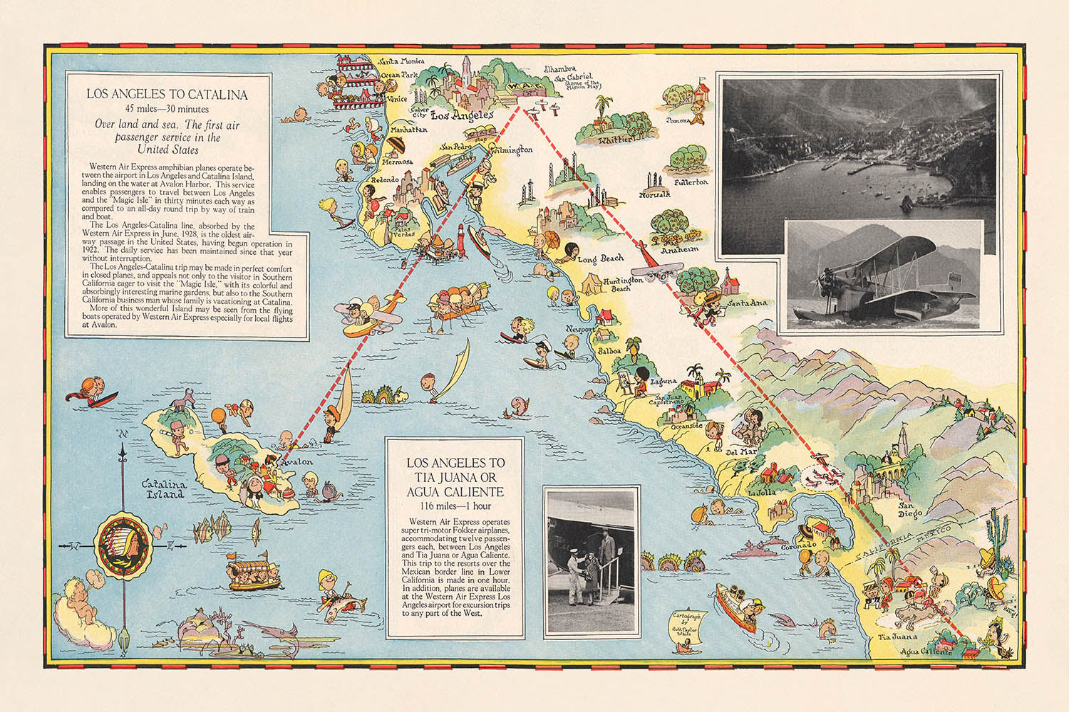
Adéntrese en la edad de oro de la aviación con este exquisito mapa pictórico de 1929, “Los Angeles to Tia Juana or...
Seguir leyendoAdéntrese en la edad de oro de la aviación con este exquisito mapa pictórico de 1929, “Los Angeles to Tia Juana or Agua Caliente. Los Angeles to Catalina,” ilustrado magistralmente por Ruth Taylor White para Western Air Express. Creado en un momento decisivo de la historia del transporte, este mapa no solo traza las incipientes rutas aéreas que conectaban el sur de California con los emergentes destinos de ocio de Baja California y la isla de Catalina, sino que también encarna el optimismo y la emoción del vuelo comercial temprano. El estilo característico de White —vibrante, caprichoso y de gran detalle— da vida a los paisajes, ciudades y enclaves recreativos que definieron esta era de rápida transformación.
La narrativa visual del mapa es a la vez práctica y encantadora. Las principales rutas aéreas están elegantemente trazadas, con indicaciones claras de distancias y tiempos de vuelo —como el rápido trayecto de 1 hora desde Los Angeles a Tia Juana (hoy Tijuana) o Agua Caliente, y el salto de 30 minutos hasta la isla de Catalina. A lo largo de estos recorridos, el observador disfruta de representaciones pictóricas de los aviones Fokker trimotores surcando cielos sobre montañas escarpadas, ciudades bulliciosas y costas tranquilas. Cada detalle sirve tanto de ayuda de navegación como de invitación a la aventura, reflejando la fascinación de la época por la velocidad, el confort y la nueva accesibilidad de destinos lejanos.
Más allá de su utilidad práctica, este mapa es una celebración de la vitalidad cultural y recreativa del sur de California y el norte de Baja California a finales de la década de 1920. Destaca una constelación de ciudades —Los Angeles, San Diego, Santa Monica, Pasadena y otras—, cada una representada con arquitectura emblemática y animadas escenas callejeras. Los sectores meridionales del mapa muestran el legendario complejo turístico de Agua Caliente, célebre por su casino y sus lujosos alojamientos, y Tia Juana, destino sinónimo de emoción y entretenimiento transfronterizos. La isla de Catalina, por su parte, se presenta como un paraíso de navegación, playas y ocio, capturando el espíritu de una época en la que el propio viaje era todo un acontecimiento.
La maestría artística de Ruth Taylor White se extiende a las vivaces ilustraciones de personas en pleno disfrute —golfistas, jinetes, bañistas y turistas—, todo ello sobre un telón de fondo de granjas, bosques y núcleos industriales. La frontera entre Estados Unidos y México está claramente señalada, subrayando el atractivo internacional de estas rutas aéreas y las aspiraciones cosmopolitas de los viajeros de la época. Esta combinación de cartografía práctica e ilustración imaginativa no solo orienta al viajero, sino que también lo invita a soñar, convirtiendo el mapa en una apreciada pieza de la historia de la aviación y del diseño gráfico.
Históricamente, este mapa se erige como testimonio del poder transformador de la aviación en el siglo XX temprano. Refleja cómo aerolíneas como Western Air Express comercializaban el viaje aéreo como una experiencia lujosa, fiable y moderna —un ethos capturado en cada detalle de la composición del mapa. Para coleccionistas, historiadores o cualquiera que sienta pasión por el romanticismo de los primeros vuelos, este mapa ofrece una rara y evocadora ventana a un mundo en el que los cielos se abrían y cada viaje prometía descubrimiento, confort y un toque de glamour.
Lugares en este mapa
- Los Angeles
- Catalina Island
- Tia Juana (Tijuana)
- Agua Caliente
- Long Beach
- San Pedro
- Santa Ana
- San Diego
- Oceanside
- Riverside
- San Bernardino
- Redlands
- Pomona
- Pasadena
- Santa Monica
- Whittier
- Fullerton
- Anaheim
- Laguna Beach
- Newport Beach
Características destacadas y lugares de interés
- Rutas aéreas claramente marcadas desde Los Ángeles a Tia Juana (Tijuana)/Agua Caliente y a la isla de Catalina
- Ilustración de un avión Fokker trimotor volando sobre el paisaje
- Logotipo de punta de flecha de Western Air Express
- Representaciones pictóricas de montañas, ríos y bosques
- Actividades recreativas representadas, como golf, equitación y navegación
- Atractivos turísticos, incluidas playas y balnearios
- Áreas industriales y granjas ilustradas a lo largo de la ruta
- Principales autopistas y carreteras mostradas conectando ciudades y pueblos
- Tiempos de vuelo y distancias indicados: 116 millas/1 hora a Tia Juana o Agua Caliente, 45 millas/30 minutos a Catalina
- Frontera entre Estados Unidos y México claramente indicada
- Relieve pictórico que muestra la topografía y las características del paisaje
- Ciudades y pueblos señalados a lo largo de las rutas aéreas
- Ilustraciones de personas practicando deportes y actividades de ocio
- La isla de Catalina representada con barcos y escenas recreativas
- Zona turística de Agua Caliente ilustrada con imágenes de casino y hotel
- Los Ángeles mostrado como un importante centro urbano con edificios prominentes
- Tia Juana (Tijuana) representada con arquitectura local distintiva
- Trayectorias de vuelo de aviones trazadas visualmente sobre el mapa
- Anotaciones de distancias entre puntos clave
- Borde decorativo y cartucho del título en estilo de época
Contexto histórico y de diseño
- Creado en octubre de 1929 por Ruth Taylor White para Western Air Express, una aerolínea pionera
- Ruth Taylor White era conocida por sus mapas pictóricos coloridos y caprichosos que combinaban arte con información práctica de viaje
- Diseñado como una guía promocional e informativa para viajeros, destacando la comodidad y la aventura de los primeros viajes aéreos
- Refleja el rápido desarrollo de la aviación comercial en Estados Unidos durante fines de la década de 1920
- Resalta el atractivo de viajar rápidamente a destinos vacacionales como la isla de Catalina y Agua Caliente, un famoso destino de resort y casino en Baja California
- El estilo del mapa es pictórico y temático, con el relieve representado visualmente en lugar de topográficamente
- Sirve como un valioso testimonio para comprender la intersección entre transporte, turismo y diseño gráfico en la América de principios del siglo XX
- Subraya la fiabilidad y modernidad de Western Air Express, con una estrategia de marketing centrada en "Speed - Comfort - Dependability"
- Ofrece una visión de los destinos y actividades de ocio populares de la época
- Celebra la vitalidad cultural y recreativa del sur de California y el norte de Baja California a finales de la década de 1920
Por favor, compruebe de nuevo las imágenes para asegurarse de que se muestra un pueblo o lugar específico en este mapa. También puede ponerse en contacto con nosotros y pedirnos que revisemos el mapa por usted.
Este mapa luce estupendo en cualquier tamaño, pero siempre recomiendo optar por un tamaño mayor si dispone de espacio. De ese modo podrá distinguir fácilmente todos los detalles.
Este mapa luce increíble en tamaños de hasta 70in (180cm). Si busca un mapa más grande, por favor póngase en contacto.
La persona modelo en las imágenes del anuncio sostiene la versión de 24x36in (60x90cm) de este mapa.
La quinta imagen del anuncio muestra un ejemplo de mi servicio de personalización de mapas.
Si buscas algo ligeramente diferente, echa un vistazo a mi colección de los mejores mapas antiguos para ver si algo más llama tu atención.
Por favor, contáctame para comprobar si una determinada ubicación, hito o elemento aparece en este mapa.
Sería un regalo maravilloso de cumpleaños, Navidad, Día del Padre, despedida del trabajo, aniversario o inauguración del hogar para alguien de las zonas cubiertas por este mapa.
Este mapa está disponible como impresión giclée en papel mate de archivo libre de ácido, o puedes comprarlo enmarcado. El marco es un bonito y sencillo marco negro que combina con la mayoría de las estéticas. Ponte en contacto si te gustaría un color o material de marco diferente. Mis marcos llevan cristal acrílico de calidad museística, ultratransparente (perspex/acrylite), que es considerablemente menos reflectante que el vidrio, más seguro y siempre llegará en perfectas condiciones.
This map is also available as a float framed canvas, sometimes known as a shadow gap framed canvas or canvas floater. The map is printed on artist's cotton canvas and then stretched over a handmade box frame. We then "float" the canvas inside a wooden frame, which is available in a range of colours (black, dark brown, oak, antique gold and white). This is a wonderful way to present a map without glazing in front. See some examples of float framed canvas maps and explore the differences between my different finishes.
For something truly unique, this map is also available in "Unique 3D", our trademarked process that dramatically transforms the map so that it has a wonderful sense of depth. We combine the original map with detailed topography and elevation data, so that mountains and the terrain really "pop". For more info and examples of 3D maps, check my Unique 3D page.
Adéntrese en la edad de oro de la aviación con este exquisito mapa pictórico de 1929, “Los Angeles to Tia Juana or Agua Caliente. Los Angeles to Catalina,” ilustrado magistralmente por Ruth Taylor White para Western Air Express. Creado en un momento decisivo de la historia del transporte, este mapa no solo traza las incipientes rutas aéreas que conectaban el sur de California con los emergentes destinos de ocio de Baja California y la isla de Catalina, sino que también encarna el optimismo y la emoción del vuelo comercial temprano. El estilo característico de White —vibrante, caprichoso y de gran detalle— da vida a los paisajes, ciudades y enclaves recreativos que definieron esta era de rápida transformación.
La narrativa visual del mapa es a la vez práctica y encantadora. Las principales rutas aéreas están elegantemente trazadas, con indicaciones claras de distancias y tiempos de vuelo —como el rápido trayecto de 1 hora desde Los Angeles a Tia Juana (hoy Tijuana) o Agua Caliente, y el salto de 30 minutos hasta la isla de Catalina. A lo largo de estos recorridos, el observador disfruta de representaciones pictóricas de los aviones Fokker trimotores surcando cielos sobre montañas escarpadas, ciudades bulliciosas y costas tranquilas. Cada detalle sirve tanto de ayuda de navegación como de invitación a la aventura, reflejando la fascinación de la época por la velocidad, el confort y la nueva accesibilidad de destinos lejanos.
Más allá de su utilidad práctica, este mapa es una celebración de la vitalidad cultural y recreativa del sur de California y el norte de Baja California a finales de la década de 1920. Destaca una constelación de ciudades —Los Angeles, San Diego, Santa Monica, Pasadena y otras—, cada una representada con arquitectura emblemática y animadas escenas callejeras. Los sectores meridionales del mapa muestran el legendario complejo turístico de Agua Caliente, célebre por su casino y sus lujosos alojamientos, y Tia Juana, destino sinónimo de emoción y entretenimiento transfronterizos. La isla de Catalina, por su parte, se presenta como un paraíso de navegación, playas y ocio, capturando el espíritu de una época en la que el propio viaje era todo un acontecimiento.
La maestría artística de Ruth Taylor White se extiende a las vivaces ilustraciones de personas en pleno disfrute —golfistas, jinetes, bañistas y turistas—, todo ello sobre un telón de fondo de granjas, bosques y núcleos industriales. La frontera entre Estados Unidos y México está claramente señalada, subrayando el atractivo internacional de estas rutas aéreas y las aspiraciones cosmopolitas de los viajeros de la época. Esta combinación de cartografía práctica e ilustración imaginativa no solo orienta al viajero, sino que también lo invita a soñar, convirtiendo el mapa en una apreciada pieza de la historia de la aviación y del diseño gráfico.
Históricamente, este mapa se erige como testimonio del poder transformador de la aviación en el siglo XX temprano. Refleja cómo aerolíneas como Western Air Express comercializaban el viaje aéreo como una experiencia lujosa, fiable y moderna —un ethos capturado en cada detalle de la composición del mapa. Para coleccionistas, historiadores o cualquiera que sienta pasión por el romanticismo de los primeros vuelos, este mapa ofrece una rara y evocadora ventana a un mundo en el que los cielos se abrían y cada viaje prometía descubrimiento, confort y un toque de glamour.
Lugares en este mapa
- Los Angeles
- Catalina Island
- Tia Juana (Tijuana)
- Agua Caliente
- Long Beach
- San Pedro
- Santa Ana
- San Diego
- Oceanside
- Riverside
- San Bernardino
- Redlands
- Pomona
- Pasadena
- Santa Monica
- Whittier
- Fullerton
- Anaheim
- Laguna Beach
- Newport Beach
Características destacadas y lugares de interés
- Rutas aéreas claramente marcadas desde Los Ángeles a Tia Juana (Tijuana)/Agua Caliente y a la isla de Catalina
- Ilustración de un avión Fokker trimotor volando sobre el paisaje
- Logotipo de punta de flecha de Western Air Express
- Representaciones pictóricas de montañas, ríos y bosques
- Actividades recreativas representadas, como golf, equitación y navegación
- Atractivos turísticos, incluidas playas y balnearios
- Áreas industriales y granjas ilustradas a lo largo de la ruta
- Principales autopistas y carreteras mostradas conectando ciudades y pueblos
- Tiempos de vuelo y distancias indicados: 116 millas/1 hora a Tia Juana o Agua Caliente, 45 millas/30 minutos a Catalina
- Frontera entre Estados Unidos y México claramente indicada
- Relieve pictórico que muestra la topografía y las características del paisaje
- Ciudades y pueblos señalados a lo largo de las rutas aéreas
- Ilustraciones de personas practicando deportes y actividades de ocio
- La isla de Catalina representada con barcos y escenas recreativas
- Zona turística de Agua Caliente ilustrada con imágenes de casino y hotel
- Los Ángeles mostrado como un importante centro urbano con edificios prominentes
- Tia Juana (Tijuana) representada con arquitectura local distintiva
- Trayectorias de vuelo de aviones trazadas visualmente sobre el mapa
- Anotaciones de distancias entre puntos clave
- Borde decorativo y cartucho del título en estilo de época
Contexto histórico y de diseño
- Creado en octubre de 1929 por Ruth Taylor White para Western Air Express, una aerolínea pionera
- Ruth Taylor White era conocida por sus mapas pictóricos coloridos y caprichosos que combinaban arte con información práctica de viaje
- Diseñado como una guía promocional e informativa para viajeros, destacando la comodidad y la aventura de los primeros viajes aéreos
- Refleja el rápido desarrollo de la aviación comercial en Estados Unidos durante fines de la década de 1920
- Resalta el atractivo de viajar rápidamente a destinos vacacionales como la isla de Catalina y Agua Caliente, un famoso destino de resort y casino en Baja California
- El estilo del mapa es pictórico y temático, con el relieve representado visualmente en lugar de topográficamente
- Sirve como un valioso testimonio para comprender la intersección entre transporte, turismo y diseño gráfico en la América de principios del siglo XX
- Subraya la fiabilidad y modernidad de Western Air Express, con una estrategia de marketing centrada en "Speed - Comfort - Dependability"
- Ofrece una visión de los destinos y actividades de ocio populares de la época
- Celebra la vitalidad cultural y recreativa del sur de California y el norte de Baja California a finales de la década de 1920
Por favor, compruebe de nuevo las imágenes para asegurarse de que se muestra un pueblo o lugar específico en este mapa. También puede ponerse en contacto con nosotros y pedirnos que revisemos el mapa por usted.
Este mapa luce estupendo en cualquier tamaño, pero siempre recomiendo optar por un tamaño mayor si dispone de espacio. De ese modo podrá distinguir fácilmente todos los detalles.
Este mapa luce increíble en tamaños de hasta 70in (180cm). Si busca un mapa más grande, por favor póngase en contacto.
La persona modelo en las imágenes del anuncio sostiene la versión de 24x36in (60x90cm) de este mapa.
La quinta imagen del anuncio muestra un ejemplo de mi servicio de personalización de mapas.
Si buscas algo ligeramente diferente, echa un vistazo a mi colección de los mejores mapas antiguos para ver si algo más llama tu atención.
Por favor, contáctame para comprobar si una determinada ubicación, hito o elemento aparece en este mapa.
Sería un regalo maravilloso de cumpleaños, Navidad, Día del Padre, despedida del trabajo, aniversario o inauguración del hogar para alguien de las zonas cubiertas por este mapa.
Este mapa está disponible como impresión giclée en papel mate de archivo libre de ácido, o puedes comprarlo enmarcado. El marco es un bonito y sencillo marco negro que combina con la mayoría de las estéticas. Ponte en contacto si te gustaría un color o material de marco diferente. Mis marcos llevan cristal acrílico de calidad museística, ultratransparente (perspex/acrylite), que es considerablemente menos reflectante que el vidrio, más seguro y siempre llegará en perfectas condiciones.
This map is also available as a float framed canvas, sometimes known as a shadow gap framed canvas or canvas floater. The map is printed on artist's cotton canvas and then stretched over a handmade box frame. We then "float" the canvas inside a wooden frame, which is available in a range of colours (black, dark brown, oak, antique gold and white). This is a wonderful way to present a map without glazing in front. See some examples of float framed canvas maps and explore the differences between my different finishes.
For something truly unique, this map is also available in "Unique 3D", our trademarked process that dramatically transforms the map so that it has a wonderful sense of depth. We combine the original map with detailed topography and elevation data, so that mountains and the terrain really "pop". For more info and examples of 3D maps, check my Unique 3D page.
Many of our maps and art prints are chosen as thoughtful gifts for homes, offices, studies and meaningful places.
Choose a framed option for the easiest ready-to-hang gift, or choose an unframed print if the recipient may prefer to select their own frame.
We make orders locally in 23 countries around the world, so gifts can often be produced close to the recipient. This helps them arrive faster, travel more safely, and avoid customs or import duty surprises.
- We can deliver directly to the recipient
- Framed pieces arrive ready to hang
- Unframed prints are carefully packed in a strong protective tube
- Almost every order is made locally, for faster, safer gifting
- 90-day returns give the recipient time to decide
If you are not sure what to choose, please contact us. We can help you pick the right map, size, finish or delivery option.
Para la mayoría de los pedidos, el tiempo de entrega es de aproximadamente 3 días laborables. Los productos personalizados y a medida tardan más, ya que tengo que hacer la personalización y enviártelo para su aprobación, lo cual suele tardar 1 o 2 días.
Tenga en cuenta que los pedidos enmarcados muy grandes suelen tardar más en fabricarse y entregarse.
Si necesitas que tu pedido llegue para una fecha determinada, por favor contáctame antes de hacer el pedido para que podamos encontrar la mejor manera de asegurarnos de que recibas tu pedido a tiempo.
Imprimo y enmarco mapas y obras de arte en 23 países alrededor del mundo. Esto significa que tu pedido se fabricará localmente, lo que reduce el tiempo de entrega y asegura que no se dañe durante el envío. Nunca pagarás aranceles de aduana o impuestos de importación, y pondremos menos CO2 en el aire.
Todos mis mapas y impresiones artísticas están bien empaquetados y enviados en un tubo resistente si no están enmarcados, o rodeados de espuma si están enmarcados.
Intento enviar todos los pedidos dentro de 1 o 2 días después de recibir tu pedido, aunque algunos productos (como mascarillas, tazas y bolsas de tela) pueden tardar más en fabricarse.
Si seleccionas Entrega Exprés al finalizar la compra, priorizaremos tu pedido y lo enviaremos por mensajería de 1 día (Fedex, DHL, UPS, Parcelforce).
La entrega al día siguiente también está disponible en algunos países (EE. UU., Reino Unido, Singapur, EAU), pero por favor intenta hacer tu pedido temprano en el día para que podamos enviarlo a tiempo.
Mi marco estándar es un marco de madera de fresno negro estilo galería. Es simple y tiene un aspecto bastante moderno. Mi marco estándar tiene alrededor de 20 mm (0.8 in) de ancho.
Utilizo acrílico super claro (perspex/acrylite) para el vidrio del marco. Es más ligero y seguro que el vidrio, y se ve mejor, ya que la reflectividad es menor.
Seis colores de marco estándar están disponibles de forma gratuita (negro, marrón oscuro, gris oscuro, roble, blanco y oro antiguo).El enmarcado y montaje/matizado personalizado está disponible si buscas algo diferente.
La mayoría de los mapas, arte e ilustraciones también están disponibles como un lienzo enmarcado. Utilizamos lienzo de algodón mate (no brillante), lo estiramos sobre un marco de madera de caja de origen sostenible, y luego 'flotamos' la pieza dentro de un marco de madera. El resultado final es bastante hermoso, y no hay cristal que se interponga.
Todos los marcos se proporcionan "listos para colgar", con una cuerda o soportes en la parte posterior. Los marcos muy grandes tendrán placas de colgar de alta resistencia y/o un listón de montaje. Si tienes alguna pregunta, por favor ponte en contacto.
Mira algunos ejemplos de mis mapas enmarcados y mapas en lienzo enmarcados.
Alternativamente, también puedo proporcionar mapas antiguos y obras de arte en lienzo, tablero de espuma, papel de algodón y otros materiales.
Si deseas enmarcar tu mapa o obra de arte tú mismo, por favor lee mi guía de tamaños primero.
Mis mapas son reproducciones de mapas originales de altísima calidad.
Obtengo mapas originales y raros de bibliotecas, casas de subastas y colecciones privadas de todo el mundo, los restauro en mi taller de Londres y luego uso tintas e impresoras giclée especializadas para crear hermosos mapas que lucen incluso mejor que el original.
Mis mapas están impresos en papel de archivo mate (no brillante) sin ácido que se siente de muy alta calidad y casi como una tarjeta. En términos técnicos, el peso/grosor del papel es de 10 mil/200 g/m². Es perfecto para enmarcar.
Imprimo con tintas pigmentadas Epson ultrachrome giclée UV resistentes a la decoloración, algunas de las mejores tintas que puedes encontrar.
yo también puedo hacer mapas sobre lienzo, trapo de algodón y otros materiales exóticos.
Obtenga más información sobre The Unique Maps Co..
Personalización de mapas
Si está buscando el regalo perfecto de aniversario o inauguración de la casa, puedo personalizar su mapa para hacerlo verdaderamente único. Por ejemplo, puedo agregar un mensaje corto, resaltar una ubicación importante o agregar el escudo de armas de su familia.
Las opciones son casi infinitas. Por favor mira mi página de personalización de mapas para ver algunos maravillosos ejemplos de lo que es posible.
Para pedir un mapa personalizado, seleccione "personalizar su mapa" antes de agregarlo a su carrito.
Ponerse en contacto si buscas personalizaciones y personalizaciones más complejas.
Envejecimiento del mapa
A lo largo de los años, los clientes me han preguntado cientos de veces si podían comprar un mapa que se viera uniforme. más viejo.
Bueno, ahora puedes hacerlo seleccionando Envejecido antes de agregar un mapa a tu carrito.
Todas las fotografías de productos que ve en esta página muestran el mapa en su forma original. Así es como se ve el mapa hoy.
Si selecciona Envejecido, envejeceré su mapa a mano, usando un proceso especial y único desarrollado a través de años de estudiar mapas antiguos, hablar con investigadores para comprender la química del envejecimiento del papel y, por supuesto... ¡mucha práctica!
Si no estás seguro, quédate con el color original del mapa. Si quieres algo un poco más oscuro y más viejo buscando, opte por Envejecido.
Si no estás satisfecho con tu pedido por cualquier motivo, contáctame para un reembolso sin complicaciones. Por favor, consulta nuestra política de devoluciones y reembolsos para más información.
Estoy muy seguro de que te gustará tu mapa o impresión artística restaurada. He estado haciendo esto desde 1984. Soy un vendedor de 5 estrellas en Etsy. He vendido decenas de miles de mapas e impresiones artísticas y tengo más de 5,000 opiniones reales de 5 estrellas.
Utilizo un proceso único para restaurar mapas y obras de arte que consume mucho tiempo y mano de obra. Buscar los mapas e ilustraciones originales puede llevar meses. Utilizo tecnología de última generación y extremadamente cara para escanear y restaurarlos. Como resultado, garantizo que mis mapas e impresiones artísticas son superiores a los demás - por eso puedo ofrecer un reembolso sin complicaciones.
Casi todos mis mapas e impresiones artísticas se ven increíbles en tamaños grandes (200cm, 6.5ft+) y también puedo enmarcarlos y entregártelos a través de un servicio de mensajería especial para tamaños grandes. Contáctame para discutir tus necesidades específicas.
Or try searching for something!


