


Rare Old Topographic Map of Tasmania by Arrowsmith, 1845: Hobart, Launceston, Derwent R, King & Flinders Is, Lake St Clair
La oferta del coleccionista
Elija dos obras elegibles y obtenga un 20 % de descuento en ambas. Elija tres y la de menor precio será gratuita, con un ahorro máximo del 33 %.
Combine y mezcle mapas estándar elegibles y reproducciones de bellas artes. No se requiere código; la oferta se aplica automáticamente al finalizar la compra.
Se incluyen las configuraciones estándar hechas por encargo. Quedan excluidos los tamaños a medida, los diseños personalizados y los trabajos por encargo.
¿Necesita entrega en diferentes direcciones? Contáctenos antes de realizar el pedido.La oferta del coleccionista
Elija dos obras elegibles y obtenga un 20 % de descuento en ambas. Elija tres y la de menor precio será gratuita, con un ahorro máximo del 33 %.
Combine y mezcle mapas estándar elegibles y reproducciones de bellas artes. No se requiere código; la oferta se aplica automáticamente al finalizar la compra.
Se incluyen las configuraciones estándar hechas por encargo. Quedan excluidos los tamaños a medida, los diseños personalizados y los trabajos por encargo.
¿Necesita entrega en diferentes direcciones? Contáctenos antes de realizar el pedido. Diseñado en Londres Hecho en the UK
Diseñado en Londres • Hecho en the UK
Diseñado en Londres Hecho en the UK
Diseñado en Londres • Hecho en the UK

Restaurado a partir del mapa original de 1845 e impreso en calidad museo. Leer la historia detrás de este mapa
Choose your size
Choose your finish


(Más información)
Mensaje de regalo y acabado personalizado

Si deseas agregar un mensaje de regalo, o un acabado (rompecabezas, tablero de aluminio, etc.) que no esté disponible aquí, por favor solicítalo en la "nota del pedido" cuando realices la compra.
Cada pedido es hecho a medida, así que si necesitas que el tamaño se ajuste ligeramente, o que se imprima en un material inusual, háznoslo saber. Hemos realizado miles de pedidos personalizados a lo largo de los años, así que hay (casi) nada que no podamos gestionar.
También puedes contactarnos antes de hacer tu pedido, ¡si lo prefieres!

- Hecho localmente. Entrega segura
- Sin aranceles ni cargos ocultos
- ¿Necesitas ayuda? Llámanos o mensaje por WhatsApp
Own a piece of history
8,000+ five-star reviews


Van Diemen's Land is presented here with quiet authority, its title anchoring a composition that balances scientific restraint and painterly grace. Issued...
Seguir leyendoVan Diemen's Land is presented here with quiet authority, its title anchoring a composition that balances scientific restraint and painterly grace. Issued in 1845 within the second edition of Arrowsmith’s New Atlas, the sheet reflects a quarter-century of revision since the first 1825 appearance, its information disciplined by the prime meridian at Greenwich and clarified through a crisp legend and precise scale bar. Hand-colored outlines pick out administrative divisions with clarity, while a lattice of rivers and roads ties coast to interior. Hachures express the muscular topography of the island, from serried ranges to weather-bitten capes, and the surrounding waters are traced with secure, confident coasts punctuated by outlying islands. The result is both a navigational instrument and a historical statement of imperial geographic order.
Aaron Jr. Arrowsmith—heir to the London firm founded by his father—spent more than 25 years distilling the world’s most reliable intelligence into maps and atlases prized by governments, mariners, and emigrants. After 1824 he extended the family’s meticulous standards, drawing on Admiralty charts, colonial surveys, and travelers’ journals to replace conjecture with evidence. His 1845 Van Diemen’s Land exemplifies that method: coastal exactitude joined to an interior increasingly mapped by road-makers, surveyors, and settlers. The plate’s judicious updates register the island’s accelerating transformation, yet its design never overwhelms. Typography is clear, symbols are discriminating, and color serves legibility rather than spectacle—hallmarks of an Arrowsmith production, where synthesis and restraint carry the reader across unfamiliar ground with unforced confidence.
The physical geography of Tasmania unfolds in finely stepped relief. Hachures articulate the mountainous backbone of the west and the broad shoulders of the Central Highlands, their slopes grading toward lake-dotted plateaux and river valleys. The Derwent threads southward past Hobart, while the Tamar leads the eye inland from the northern coast to Launceston; the Mersey and Huon are equally well stated, with smaller tributaries delicately feathered. Lakes Sorell and Crescent punctuate the interior, while Lake St Clair anchors the high country. Around the coasts, headlands and embayments are cleanly drawn, and the outliers of Bass Strait—King Island to the northwest and the Furneaux Group with Flinders Island to the northeast—frame the island within its maritime setting, signaling routes, risks, and resources.
Arrowsmith balances terrain with the living geography of settlement and administration. Hand-colored borders subdivide the colony into recognizable counties and districts, rendering governance legible at a glance. Cities and towns are marked with crisp prominence—Hobart and Launceston foremost, with Devonport, Burnie, and Kingston likewise inscribed—while the road network ties these nodes together in practical skeins. The principal overland artery between Hobart and Launceston is clearly indicated, its branches reaching eastward to coastal townships and westward toward resource-rich country. Ports, anchorages, ferries, and river crossings are signaled with unobtrusive symbols explained in the legend, helping the reader decode movement and connection across an island where sea-lanes, coach roads, and river valleys shaped every economic and social exchange.
Historically, this map sits at a pivotal moment: Van Diemen’s Land, still bearing its penal-era name, was turning toward a broader civic identity that would culminate in the adoption of “Tasmania” a decade later. The 1845 state of knowledge—codified here through Greenwich-referenced longitudes, measured scales, and a disciplined symbology—captures that transition in cartographic form. As a tool, it served administrators, surveyors, and voyagers; as an artifact, it testifies to the British project of knowing and ordering distant lands. Its careful updates across a 25-year span allow one to read change itself—new roads stitched in, districts redefined, settlements brightening into towns—while its elegant economy of line and color ensures the island’s varied character remains the true subject on the page.
Cities and towns on this map
- Hobart (capital and largest city)
- Launceston
- Devonport
- Burnie
- Kingston
Notable Features & Landmarks
- Hand-colored administrative boundaries
- Cities and towns marked prominently
- Major rivers and lakes outlined
- Roads connecting various settlements depicted
- Depiction of islands surrounding Van Diemen's Land
- Hachured relief indicating mountainous regions
- Prime meridian established at Greenwich noted
- Legend or explanatory notes providing essential details on map features
- Scale bar indicating distance measurements
Historical and design context
- Creation Date: 1845
- Mapmaker: Aaron Jr. Arrowsmith — produced detailed maps and atlases for over 25 years, continuing A. Arrowsmith Sr.’s legacy after 1824
- Edition Context: Part of the second edition of “Arrowsmith’s New Atlas” (first published 1825), updated to reflect 25 years of geographical changes
- Geographical Coverage: Focuses on Van Diemen’s Land (now Tasmania) and surrounding waters
- Historical Significance: Captures significant early 19th-century geographical changes and serves as both a navigational tool and historical artifact
Please double check the images to make sure that a specific town or place is shown on this map. You can also get in touch and ask us to check the map for you.
This map looks great at every size, but I always recommend going for a larger size if you have space. That way you can easily make out all of the details.
This map looks amazing at sizes all the way up to 50in (125cm). If you are looking for a larger map, please get in touch.
The model in the listing images is holding the 16x20in (40x50cm) version of this map.
The fifth listing image shows an example of my map personalisation service.
If you’re looking for something slightly different, check out my collection of the best old maps to see if something else catches your eye.
Please contact me to check if a certain location, landmark or feature is shown on this map.
This would make a wonderful birthday, Christmas, Father's Day, work leaving, anniversary or housewarming gift for someone from the areas covered by this map.
This map is available as a giclée print on acid free archival matte paper, or you can buy it framed. The frame is a nice, simple black frame that suits most aesthetics. Please get in touch if you'd like a different frame colour or material. My frames are glazed with super-clear museum-grade acrylic (perspex/acrylite), which is significantly less reflective than glass, safer, and will always arrive in perfect condition.
This map is also available as a float framed canvas, sometimes known as a shadow gap framed canvas or canvas floater. The map is printed on artist's cotton canvas and then stretched over a handmade box frame. We then "float" the canvas inside a wooden frame, which is available in a range of colours (black, dark brown, oak, antique gold and white). This is a wonderful way to present a map without glazing in front. See some examples of float framed canvas maps and explore the differences between my different finishes.
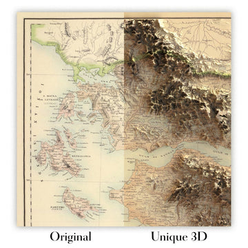
For something truly unique, this map is also available in "Unique 3D", our trademarked process that dramatically transforms the map so that it has a wonderful sense of depth. We combine the original map with detailed topography and elevation data, so that mountains and the terrain really "pop". For more info and examples of 3D maps, check my Unique 3D page.
Van Diemen's Land is presented here with quiet authority, its title anchoring a composition that balances scientific restraint and painterly grace. Issued in 1845 within the second edition of Arrowsmith’s New Atlas, the sheet reflects a quarter-century of revision since the first 1825 appearance, its information disciplined by the prime meridian at Greenwich and clarified through a crisp legend and precise scale bar. Hand-colored outlines pick out administrative divisions with clarity, while a lattice of rivers and roads ties coast to interior. Hachures express the muscular topography of the island, from serried ranges to weather-bitten capes, and the surrounding waters are traced with secure, confident coasts punctuated by outlying islands. The result is both a navigational instrument and a historical statement of imperial geographic order.
Aaron Jr. Arrowsmith—heir to the London firm founded by his father—spent more than 25 years distilling the world’s most reliable intelligence into maps and atlases prized by governments, mariners, and emigrants. After 1824 he extended the family’s meticulous standards, drawing on Admiralty charts, colonial surveys, and travelers’ journals to replace conjecture with evidence. His 1845 Van Diemen’s Land exemplifies that method: coastal exactitude joined to an interior increasingly mapped by road-makers, surveyors, and settlers. The plate’s judicious updates register the island’s accelerating transformation, yet its design never overwhelms. Typography is clear, symbols are discriminating, and color serves legibility rather than spectacle—hallmarks of an Arrowsmith production, where synthesis and restraint carry the reader across unfamiliar ground with unforced confidence.
The physical geography of Tasmania unfolds in finely stepped relief. Hachures articulate the mountainous backbone of the west and the broad shoulders of the Central Highlands, their slopes grading toward lake-dotted plateaux and river valleys. The Derwent threads southward past Hobart, while the Tamar leads the eye inland from the northern coast to Launceston; the Mersey and Huon are equally well stated, with smaller tributaries delicately feathered. Lakes Sorell and Crescent punctuate the interior, while Lake St Clair anchors the high country. Around the coasts, headlands and embayments are cleanly drawn, and the outliers of Bass Strait—King Island to the northwest and the Furneaux Group with Flinders Island to the northeast—frame the island within its maritime setting, signaling routes, risks, and resources.
Arrowsmith balances terrain with the living geography of settlement and administration. Hand-colored borders subdivide the colony into recognizable counties and districts, rendering governance legible at a glance. Cities and towns are marked with crisp prominence—Hobart and Launceston foremost, with Devonport, Burnie, and Kingston likewise inscribed—while the road network ties these nodes together in practical skeins. The principal overland artery between Hobart and Launceston is clearly indicated, its branches reaching eastward to coastal townships and westward toward resource-rich country. Ports, anchorages, ferries, and river crossings are signaled with unobtrusive symbols explained in the legend, helping the reader decode movement and connection across an island where sea-lanes, coach roads, and river valleys shaped every economic and social exchange.
Historically, this map sits at a pivotal moment: Van Diemen’s Land, still bearing its penal-era name, was turning toward a broader civic identity that would culminate in the adoption of “Tasmania” a decade later. The 1845 state of knowledge—codified here through Greenwich-referenced longitudes, measured scales, and a disciplined symbology—captures that transition in cartographic form. As a tool, it served administrators, surveyors, and voyagers; as an artifact, it testifies to the British project of knowing and ordering distant lands. Its careful updates across a 25-year span allow one to read change itself—new roads stitched in, districts redefined, settlements brightening into towns—while its elegant economy of line and color ensures the island’s varied character remains the true subject on the page.
Cities and towns on this map
- Hobart (capital and largest city)
- Launceston
- Devonport
- Burnie
- Kingston
Notable Features & Landmarks
- Hand-colored administrative boundaries
- Cities and towns marked prominently
- Major rivers and lakes outlined
- Roads connecting various settlements depicted
- Depiction of islands surrounding Van Diemen's Land
- Hachured relief indicating mountainous regions
- Prime meridian established at Greenwich noted
- Legend or explanatory notes providing essential details on map features
- Scale bar indicating distance measurements
Historical and design context
- Creation Date: 1845
- Mapmaker: Aaron Jr. Arrowsmith — produced detailed maps and atlases for over 25 years, continuing A. Arrowsmith Sr.’s legacy after 1824
- Edition Context: Part of the second edition of “Arrowsmith’s New Atlas” (first published 1825), updated to reflect 25 years of geographical changes
- Geographical Coverage: Focuses on Van Diemen’s Land (now Tasmania) and surrounding waters
- Historical Significance: Captures significant early 19th-century geographical changes and serves as both a navigational tool and historical artifact
Please double check the images to make sure that a specific town or place is shown on this map. You can also get in touch and ask us to check the map for you.
This map looks great at every size, but I always recommend going for a larger size if you have space. That way you can easily make out all of the details.
This map looks amazing at sizes all the way up to 50in (125cm). If you are looking for a larger map, please get in touch.
The model in the listing images is holding the 16x20in (40x50cm) version of this map.
The fifth listing image shows an example of my map personalisation service.
If you’re looking for something slightly different, check out my collection of the best old maps to see if something else catches your eye.
Please contact me to check if a certain location, landmark or feature is shown on this map.
This would make a wonderful birthday, Christmas, Father's Day, work leaving, anniversary or housewarming gift for someone from the areas covered by this map.
This map is available as a giclée print on acid free archival matte paper, or you can buy it framed. The frame is a nice, simple black frame that suits most aesthetics. Please get in touch if you'd like a different frame colour or material. My frames are glazed with super-clear museum-grade acrylic (perspex/acrylite), which is significantly less reflective than glass, safer, and will always arrive in perfect condition.
This map is also available as a float framed canvas, sometimes known as a shadow gap framed canvas or canvas floater. The map is printed on artist's cotton canvas and then stretched over a handmade box frame. We then "float" the canvas inside a wooden frame, which is available in a range of colours (black, dark brown, oak, antique gold and white). This is a wonderful way to present a map without glazing in front. See some examples of float framed canvas maps and explore the differences between my different finishes.
For something truly unique, this map is also available in "Unique 3D", our trademarked process that dramatically transforms the map so that it has a wonderful sense of depth. We combine the original map with detailed topography and elevation data, so that mountains and the terrain really "pop". For more info and examples of 3D maps, check my Unique 3D page.
Many of our maps and art prints are chosen as thoughtful gifts for homes, offices, studies and meaningful places.
Choose a framed option for the easiest ready-to-hang gift, or choose an unframed print if the recipient may prefer to select their own frame.
We make orders locally in 23 countries around the world, so gifts can often be produced close to the recipient. This helps them arrive faster, travel more safely, and avoid customs or import duty surprises.
- We can deliver directly to the recipient
- Framed pieces arrive ready to hang
- Unframed prints are carefully packed in a strong protective tube
- Almost every order is made locally, for faster, safer gifting
- 90-day returns give the recipient time to decide
If you are not sure what to choose, please contact us. We can help you pick the right map, size, finish or delivery option.
Para la mayoría de los pedidos, el tiempo de entrega es de aproximadamente 3 días laborables. Los productos personalizados y a medida tardan más, ya que tengo que hacer la personalización y enviártelo para su aprobación, lo cual suele tardar 1 o 2 días.
Tenga en cuenta que los pedidos enmarcados muy grandes suelen tardar más en fabricarse y entregarse.
Si necesitas que tu pedido llegue para una fecha determinada, por favor contáctame antes de hacer el pedido para que podamos encontrar la mejor manera de asegurarnos de que recibas tu pedido a tiempo.
Imprimo y enmarco mapas y obras de arte en 23 países alrededor del mundo. Esto significa que tu pedido se fabricará localmente, lo que reduce el tiempo de entrega y asegura que no se dañe durante el envío. Nunca pagarás aranceles de aduana o impuestos de importación, y pondremos menos CO2 en el aire.
Todos mis mapas y impresiones artísticas están bien empaquetados y enviados en un tubo resistente si no están enmarcados, o rodeados de espuma si están enmarcados.
Intento enviar todos los pedidos dentro de 1 o 2 días después de recibir tu pedido, aunque algunos productos (como mascarillas, tazas y bolsas de tela) pueden tardar más en fabricarse.
Si seleccionas Entrega Exprés al finalizar la compra, priorizaremos tu pedido y lo enviaremos por mensajería de 1 día (Fedex, DHL, UPS, Parcelforce).
La entrega al día siguiente también está disponible en algunos países (EE. UU., Reino Unido, Singapur, EAU), pero por favor intenta hacer tu pedido temprano en el día para que podamos enviarlo a tiempo.
Mi marco estándar es un marco de madera de fresno negro estilo galería. Es simple y tiene un aspecto bastante moderno. Mi marco estándar tiene alrededor de 20 mm (0.8 in) de ancho.
Utilizo acrílico super claro (perspex/acrylite) para el vidrio del marco. Es más ligero y seguro que el vidrio, y se ve mejor, ya que la reflectividad es menor.
Seis colores de marco estándar están disponibles de forma gratuita (negro, marrón oscuro, gris oscuro, roble, blanco y oro antiguo).El enmarcado y montaje/matizado personalizado está disponible si buscas algo diferente.
La mayoría de los mapas, arte e ilustraciones también están disponibles como un lienzo enmarcado. Utilizamos lienzo de algodón mate (no brillante), lo estiramos sobre un marco de madera de caja de origen sostenible, y luego 'flotamos' la pieza dentro de un marco de madera. El resultado final es bastante hermoso, y no hay cristal que se interponga.
Todos los marcos se proporcionan "listos para colgar", con una cuerda o soportes en la parte posterior. Los marcos muy grandes tendrán placas de colgar de alta resistencia y/o un listón de montaje. Si tienes alguna pregunta, por favor ponte en contacto.
Mira algunos ejemplos de mis mapas enmarcados y mapas en lienzo enmarcados.
Alternativamente, también puedo proporcionar mapas antiguos y obras de arte en lienzo, tablero de espuma, papel de algodón y otros materiales.
Si deseas enmarcar tu mapa o obra de arte tú mismo, por favor lee mi guía de tamaños primero.
Mis mapas son reproducciones de mapas originales de altísima calidad.
Obtengo mapas originales y raros de bibliotecas, casas de subastas y colecciones privadas de todo el mundo, los restauro en mi taller de Londres y luego uso tintas e impresoras giclée especializadas para crear hermosos mapas que lucen incluso mejor que el original.
Mis mapas están impresos en papel de archivo mate (no brillante) sin ácido que se siente de muy alta calidad y casi como una tarjeta. En términos técnicos, el peso/grosor del papel es de 10 mil/200 g/m². Es perfecto para enmarcar.
Imprimo con tintas pigmentadas Epson ultrachrome giclée UV resistentes a la decoloración, algunas de las mejores tintas que puedes encontrar.
yo también puedo hacer mapas sobre lienzo, trapo de algodón y otros materiales exóticos.
Obtenga más información sobre The Unique Maps Co..
Personalización de mapas
Si está buscando el regalo perfecto de aniversario o inauguración de la casa, puedo personalizar su mapa para hacerlo verdaderamente único. Por ejemplo, puedo agregar un mensaje corto, resaltar una ubicación importante o agregar el escudo de armas de su familia.
Las opciones son casi infinitas. Por favor mira mi página de personalización de mapas para ver algunos maravillosos ejemplos de lo que es posible.
Para pedir un mapa personalizado, seleccione "personalizar su mapa" antes de agregarlo a su carrito.
Ponerse en contacto si buscas personalizaciones y personalizaciones más complejas.
Envejecimiento del mapa
A lo largo de los años, los clientes me han preguntado cientos de veces si podían comprar un mapa que se viera uniforme. más viejo.
Bueno, ahora puedes hacerlo seleccionando Envejecido antes de agregar un mapa a tu carrito.
Todas las fotografías de productos que ve en esta página muestran el mapa en su forma original. Así es como se ve el mapa hoy.
Si selecciona Envejecido, envejeceré su mapa a mano, usando un proceso especial y único desarrollado a través de años de estudiar mapas antiguos, hablar con investigadores para comprender la química del envejecimiento del papel y, por supuesto... ¡mucha práctica!
Si no estás seguro, quédate con el color original del mapa. Si quieres algo un poco más oscuro y más viejo buscando, opte por Envejecido.
Si no estás satisfecho con tu pedido por cualquier motivo, contáctame para un reembolso sin complicaciones. Por favor, consulta nuestra política de devoluciones y reembolsos para más información.
Estoy muy seguro de que te gustará tu mapa o impresión artística restaurada. He estado haciendo esto desde 1984. Soy un vendedor de 5 estrellas en Etsy. He vendido decenas de miles de mapas e impresiones artísticas y tengo más de 5,000 opiniones reales de 5 estrellas.
Utilizo un proceso único para restaurar mapas y obras de arte que consume mucho tiempo y mano de obra. Buscar los mapas e ilustraciones originales puede llevar meses. Utilizo tecnología de última generación y extremadamente cara para escanear y restaurarlos. Como resultado, garantizo que mis mapas e impresiones artísticas son superiores a los demás - por eso puedo ofrecer un reembolso sin complicaciones.
Casi todos mis mapas e impresiones artísticas se ven increíbles en tamaños grandes (200cm, 6.5ft+) y también puedo enmarcarlos y entregártelos a través de un servicio de mensajería especial para tamaños grandes. Contáctame para discutir tus necesidades específicas.
Or try searching for something!


