


Antiguo mapa turístico pictórico de Benelux, 1950: optimismo de posguerra, Bruselas, Ámsterdam, Rin, molinos de viento
La oferta del coleccionista
Elija dos obras elegibles y obtenga un 20 % de descuento en ambas. Elija tres y la de menor precio será gratuita, con un ahorro máximo del 33 %.
Combine y mezcle mapas estándar elegibles y reproducciones de bellas artes. No se requiere código; la oferta se aplica automáticamente al finalizar la compra.
Se incluyen las configuraciones estándar hechas por encargo. Quedan excluidos los tamaños a medida, los diseños personalizados y los trabajos por encargo.
¿Necesita entrega en diferentes direcciones? Contáctenos antes de realizar el pedido.La oferta del coleccionista
Elija dos obras elegibles y obtenga un 20 % de descuento en ambas. Elija tres y la de menor precio será gratuita, con un ahorro máximo del 33 %.
Combine y mezcle mapas estándar elegibles y reproducciones de bellas artes. No se requiere código; la oferta se aplica automáticamente al finalizar la compra.
Se incluyen las configuraciones estándar hechas por encargo. Quedan excluidos los tamaños a medida, los diseños personalizados y los trabajos por encargo.
¿Necesita entrega en diferentes direcciones? Contáctenos antes de realizar el pedido. Diseñado en Londres Hecho en the UK
Diseñado en Londres • Hecho en the UK
Diseñado en Londres Hecho en the UK
Diseñado en Londres • Hecho en the UK

Restaurado a partir del mapa original de 1950 e impreso en calidad museo. Leer la historia detrás de este mapa
Choose your size
Choose your finish


(Más información)
Mensaje de regalo y acabado personalizado

Si deseas agregar un mensaje de regalo, o un acabado (rompecabezas, tablero de aluminio, etc.) que no esté disponible aquí, por favor solicítalo en la "nota del pedido" cuando realices la compra.
Cada pedido es hecho a medida, así que si necesitas que el tamaño se ajuste ligeramente, o que se imprima en un material inusual, háznoslo saber. Hemos realizado miles de pedidos personalizados a lo largo de los años, así que hay (casi) nada que no podamos gestionar.
También puedes contactarnos antes de hacer tu pedido, ¡si lo prefieres!

- Hecho localmente. Entrega segura
- Sin aranceles ni cargos ocultos
- ¿Necesitas ayuda? Llámanos o mensaje por WhatsApp
Own a piece of history
8,000+ five-star reviews


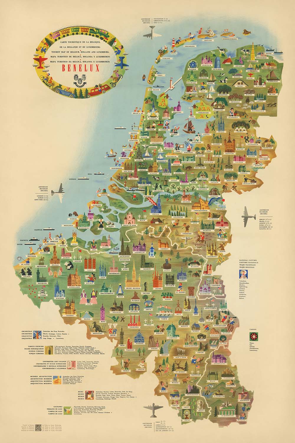
Adéntrese en el vibrante mundo de la Europa de posguerra con la “Carte Touristique de la Belgique, de la Hollande et du...
Seguir leyendoAdéntrese en el vibrante mundo de la Europa de posguerra con la “Carte Touristique de la Belgique, de la Hollande et du Luxembourg,” un cautivador mapa pictórico elaborado en 1950 por los renombrados Libra Studios en colaboración con Kühhn & Zoon. Esta exquisita pieza es una celebración visual de la región del Benelux, que refleja el optimismo y el dinamismo del renacimiento turístico de Europa Occidental tras la Segunda Guerra Mundial. El título original en francés del mapa evoca de inmediato una sensación de aventura, prometiendo un viaje por el corazón de Bélgica, los Países Bajos y Luxemburgo, todo ello representado en una rica y atractiva litografía offset.
Kühn & Zoon, una distinguida editorial neerlandesa, fue célebre por su arte y precisión en la cartografía durante mediados del siglo XX. Su colaboración con Libra Studios dio lugar a mapas que no solo eran funcionales, sino también visualmente encantadores. Este mapa en particular es testimonio de su pericia, al fusionar a la perfección información práctica de viaje con un estilo pictórico y lúdico. Cada detalle, desde los ríos sinuosos hasta las delicadas ilustraciones de monumentos, demuestra un dominio tanto del diseño como de la geografía, invitando al espectador a explorar y apreciar el carácter singular de la región.
El diseño del mapa es un deleite para la vista, adornado con animadas ilustraciones de monumentos emblemáticos, molinos de viento, castillos y catedrales que definen el paisaje cultural de los países del Benelux. Ríos principales como el Rin, el Mosa y el Escalda serpentean por el territorio, mientras la costa del mar del Norte enmarca el borde occidental del mapa. Las fronteras están claramente delimitadas, y el mapa se embellece además con banderas nacionales, escudos de armas y una rosa de los vientos decorativa, ofreciendo una armoniosa combinación de arte e información característica de las mejores obras cartográficas de la época.
Más allá de su atractivo visual, el mapa es rico en detalles temáticos, destacando las actividades de ocio que florecieron en la década de 1950. Campos de golf, rutas de senderismo y aeropuertos se señalan con encantadores iconos, reflejando el creciente entusiasmo por los viajes y las actividades al aire libre en la posguerra. Bosques, parques y regiones montañosas—especialmente en el sur de Bélgica y Luxemburgo—están representados en verdes intensos y contornos suaves, mientras que viñetas pictóricas capturan industrias regionales como el cultivo de tulipanes en los Países Bajos y la elaboración de cerveza en Bélgica. Esta cuidada selección de contenido convierte al mapa en una guía práctica y en un delicioso testimonio del turismo de mediados de siglo.
Un vistazo al mapa revela una constelación de ciudades y localidades históricas, cada una con su propia historia que contar. Desde el cosmopolita esplendor de Bruselas y Ámsterdam hasta el encanto medieval de Brujas y la Ciudad de Luxemburgo, el mapa muestra los centros urbanos más importantes de la región, ordenados según su perdurable relevancia. La cuidadosa ubicación de los asentamientos, junto con monumentos ilustrados y elementos naturales, crea un tableau dinámico que captura el espíritu del Benelux en un momento crucial de su historia. Para coleccionistas y conocedores, este mapa no es solo una herramienta de navegación, sino una ventana a una época pasada de exploración, arte y unidad europea.
Ciudades y localidades en este mapa
- Bélgica (ordenadas según la población actual):
- Bruselas (Bruxelles/Brussel)
- Amberes (Antwerpen)
- Gante (Gent)
- Charleroi
- Lieja
- Brujas (Brugge)
- Namur
- Lovaina
- Mons
- Ostende (Oostende)
- Malinas
- Hasselt
- Tournai (Doornik)
- Courtrai
- Sint-Niklaas
-
Arlon
-
Países Bajos (ordenados por población actual):
- Ámsterdam
- Róterdam
- La Haya (Den Haag/'s-Gravenhage)
- Utrecht
- Eindhoven
- Tilburgo
- Groninga
- Breda
- Nimega
- Enschede
- Haarlem
- Arnhem
- Dordrecht
- Leiden
- Maastricht
- Apeldoorn
- Amersfoort
- Zwolle
- Leeuwarden
- Den Bosch (’s-Hertogenbosch)
- Alkmaar
- Hilversum
-
Middelburg
-
Luxemburgo:
- Ciudad de Luxemburgo (Luxembourg/Ville de Luxembourg)
- Esch-sur-Alzette
Características y puntos de referencia destacados
- Ilustraciones de hitos y monumentos clave (p. ej., molinos de viento, catedrales, castillos)
- Ríos principales (p. ej., el Rin, Mosa/Maas, Escalda)
- Costeras y el mar del Norte
- Fronteras entre Bélgica, los Países Bajos y Luxemburgo, así como con los países vecinos (Francia, Alemania)
- Aeropuertos, indicados con símbolos de avión
- Campos de golf y rutas de senderismo, representados con iconos temáticos
- Zonas boscosas y parques, mostrados con elementos pictóricos verdes
- Regiones montañosas o accidentadas, especialmente en el sur de Bélgica y Luxemburgo, ilustradas con colinas estilizadas
- Representaciones pictóricas de industrias regionales o actividades culturales (p. ej., campos de tulipanes en los Países Bajos, elaboración de cerveza en Bélgica)
- Rosa de los vientos y cartela decorativas
- Banderas nacionales o escudos de Bélgica, los Países Bajos y Luxemburgo
Contexto histórico y de diseño
- Creado en 1950, reflejando el auge de los viajes en Europa occidental tras la Segunda Guerra Mundial
- Realizado por Libra Studios / Kühn & Zoon, una reconocida editorial neerlandesa conocida por sus mapas pictóricos y temáticos
- El mapa es una vibrante litografía offset, que combina información práctica de viaje con un arte colorido y atractivo
- Se centra en la región del Benelux: Bélgica, los Países Bajos y Luxemburgo
- Destaca actividades y atracciones turísticas, como campos de golf, rutas de senderismo y aeropuertos
- Sirve tanto como guía práctica como herramienta promocional para el turismo y el intercambio cultural en los primeros años de la recuperación europea
- Presenta una combinación armoniosa de arte e información, característica de las obras cartográficas de mediados del siglo XX
Por favor, compruebe bien las imágenes para asegurarse de que se muestra en este mapa una ciudad o lugar concreto. También puede ponerse en contacto con nosotros y pedirnos que revisemos el mapa por usted.
Este mapa queda genial en cualquier tamaño, pero siempre recomiendo optar por un tamaño mayor si dispone de espacio. Así podrá apreciar fácilmente todos los detalles.
Este mapa luce increíble en tamaños de hasta 100in (250cm). Si busca un mapa más grande, por favor póngase en contacto.
Por favor, tenga en cuenta: las etiquetas de este mapa son difíciles de leer si pide un mapa de 16in (40cm) o menos. El mapa sigue siendo muy atractivo, pero si desea leerlo con facilidad, le recomendamos comprar un tamaño mayor.
El modelo de las imágenes del anuncio sostiene la versión de 24x36in (60x90cm) de este mapa.
La quinta imagen del anuncio muestra un ejemplo de mi servicio de personalización de mapas.
Si busca algo ligeramente diferente, eche un vistazo a mi colección de los mejores mapas antiguos para ver si algo más llama su atención.
Por favor, contácteme para comprobar si una determinada localidad, punto de referencia o elemento aparece en este mapa.
Este sería un maravilloso regalo de cumpleaños, Navidad, Día del Padre, despedida de trabajo, aniversario o inauguración de casa para alguien de las zonas cubiertas por este mapa.
Este mapa está disponible como impresión giclée en papel mate de archivo libre de ácido, o puede adquirirlo enmarcado. El marco es un elegante y sencillo marco negro que se adapta a la mayoría de las estéticas. Póngase en contacto si desea un color o material de marco diferente. Mis marcos están acristalados con acrílico de calidad museo supertransparente (perspex/acrylite), que es considerablemente menos reflectante que el vidrio, más seguro y siempre llegará en perfectas condiciones.
This map is also available as a float framed canvas, sometimes known as a shadow gap framed canvas or canvas floater. The map is printed on artist's cotton canvas and then stretched over a handmade box frame. We then "float" the canvas inside a wooden frame, which is available in a range of colours (black, dark brown, oak, antique gold and white). This is a wonderful way to present a map without glazing in front. See some examples of float framed canvas maps and explore the differences between my different finishes.
For something truly unique, this map is also available in "Unique 3D", our trademarked process that dramatically transforms the map so that it has a wonderful sense of depth. We combine the original map with detailed topography and elevation data, so that mountains and the terrain really "pop". For more info and examples of 3D maps, check my Unique 3D page.
Adéntrese en el vibrante mundo de la Europa de posguerra con la “Carte Touristique de la Belgique, de la Hollande et du Luxembourg,” un cautivador mapa pictórico elaborado en 1950 por los renombrados Libra Studios en colaboración con Kühhn & Zoon. Esta exquisita pieza es una celebración visual de la región del Benelux, que refleja el optimismo y el dinamismo del renacimiento turístico de Europa Occidental tras la Segunda Guerra Mundial. El título original en francés del mapa evoca de inmediato una sensación de aventura, prometiendo un viaje por el corazón de Bélgica, los Países Bajos y Luxemburgo, todo ello representado en una rica y atractiva litografía offset.
Kühn & Zoon, una distinguida editorial neerlandesa, fue célebre por su arte y precisión en la cartografía durante mediados del siglo XX. Su colaboración con Libra Studios dio lugar a mapas que no solo eran funcionales, sino también visualmente encantadores. Este mapa en particular es testimonio de su pericia, al fusionar a la perfección información práctica de viaje con un estilo pictórico y lúdico. Cada detalle, desde los ríos sinuosos hasta las delicadas ilustraciones de monumentos, demuestra un dominio tanto del diseño como de la geografía, invitando al espectador a explorar y apreciar el carácter singular de la región.
El diseño del mapa es un deleite para la vista, adornado con animadas ilustraciones de monumentos emblemáticos, molinos de viento, castillos y catedrales que definen el paisaje cultural de los países del Benelux. Ríos principales como el Rin, el Mosa y el Escalda serpentean por el territorio, mientras la costa del mar del Norte enmarca el borde occidental del mapa. Las fronteras están claramente delimitadas, y el mapa se embellece además con banderas nacionales, escudos de armas y una rosa de los vientos decorativa, ofreciendo una armoniosa combinación de arte e información característica de las mejores obras cartográficas de la época.
Más allá de su atractivo visual, el mapa es rico en detalles temáticos, destacando las actividades de ocio que florecieron en la década de 1950. Campos de golf, rutas de senderismo y aeropuertos se señalan con encantadores iconos, reflejando el creciente entusiasmo por los viajes y las actividades al aire libre en la posguerra. Bosques, parques y regiones montañosas—especialmente en el sur de Bélgica y Luxemburgo—están representados en verdes intensos y contornos suaves, mientras que viñetas pictóricas capturan industrias regionales como el cultivo de tulipanes en los Países Bajos y la elaboración de cerveza en Bélgica. Esta cuidada selección de contenido convierte al mapa en una guía práctica y en un delicioso testimonio del turismo de mediados de siglo.
Un vistazo al mapa revela una constelación de ciudades y localidades históricas, cada una con su propia historia que contar. Desde el cosmopolita esplendor de Bruselas y Ámsterdam hasta el encanto medieval de Brujas y la Ciudad de Luxemburgo, el mapa muestra los centros urbanos más importantes de la región, ordenados según su perdurable relevancia. La cuidadosa ubicación de los asentamientos, junto con monumentos ilustrados y elementos naturales, crea un tableau dinámico que captura el espíritu del Benelux en un momento crucial de su historia. Para coleccionistas y conocedores, este mapa no es solo una herramienta de navegación, sino una ventana a una época pasada de exploración, arte y unidad europea.
Ciudades y localidades en este mapa
- Bélgica (ordenadas según la población actual):
- Bruselas (Bruxelles/Brussel)
- Amberes (Antwerpen)
- Gante (Gent)
- Charleroi
- Lieja
- Brujas (Brugge)
- Namur
- Lovaina
- Mons
- Ostende (Oostende)
- Malinas
- Hasselt
- Tournai (Doornik)
- Courtrai
- Sint-Niklaas
-
Arlon
-
Países Bajos (ordenados por población actual):
- Ámsterdam
- Róterdam
- La Haya (Den Haag/'s-Gravenhage)
- Utrecht
- Eindhoven
- Tilburgo
- Groninga
- Breda
- Nimega
- Enschede
- Haarlem
- Arnhem
- Dordrecht
- Leiden
- Maastricht
- Apeldoorn
- Amersfoort
- Zwolle
- Leeuwarden
- Den Bosch (’s-Hertogenbosch)
- Alkmaar
- Hilversum
-
Middelburg
-
Luxemburgo:
- Ciudad de Luxemburgo (Luxembourg/Ville de Luxembourg)
- Esch-sur-Alzette
Características y puntos de referencia destacados
- Ilustraciones de hitos y monumentos clave (p. ej., molinos de viento, catedrales, castillos)
- Ríos principales (p. ej., el Rin, Mosa/Maas, Escalda)
- Costeras y el mar del Norte
- Fronteras entre Bélgica, los Países Bajos y Luxemburgo, así como con los países vecinos (Francia, Alemania)
- Aeropuertos, indicados con símbolos de avión
- Campos de golf y rutas de senderismo, representados con iconos temáticos
- Zonas boscosas y parques, mostrados con elementos pictóricos verdes
- Regiones montañosas o accidentadas, especialmente en el sur de Bélgica y Luxemburgo, ilustradas con colinas estilizadas
- Representaciones pictóricas de industrias regionales o actividades culturales (p. ej., campos de tulipanes en los Países Bajos, elaboración de cerveza en Bélgica)
- Rosa de los vientos y cartela decorativas
- Banderas nacionales o escudos de Bélgica, los Países Bajos y Luxemburgo
Contexto histórico y de diseño
- Creado en 1950, reflejando el auge de los viajes en Europa occidental tras la Segunda Guerra Mundial
- Realizado por Libra Studios / Kühn & Zoon, una reconocida editorial neerlandesa conocida por sus mapas pictóricos y temáticos
- El mapa es una vibrante litografía offset, que combina información práctica de viaje con un arte colorido y atractivo
- Se centra en la región del Benelux: Bélgica, los Países Bajos y Luxemburgo
- Destaca actividades y atracciones turísticas, como campos de golf, rutas de senderismo y aeropuertos
- Sirve tanto como guía práctica como herramienta promocional para el turismo y el intercambio cultural en los primeros años de la recuperación europea
- Presenta una combinación armoniosa de arte e información, característica de las obras cartográficas de mediados del siglo XX
Por favor, compruebe bien las imágenes para asegurarse de que se muestra en este mapa una ciudad o lugar concreto. También puede ponerse en contacto con nosotros y pedirnos que revisemos el mapa por usted.
Este mapa queda genial en cualquier tamaño, pero siempre recomiendo optar por un tamaño mayor si dispone de espacio. Así podrá apreciar fácilmente todos los detalles.
Este mapa luce increíble en tamaños de hasta 100in (250cm). Si busca un mapa más grande, por favor póngase en contacto.
Por favor, tenga en cuenta: las etiquetas de este mapa son difíciles de leer si pide un mapa de 16in (40cm) o menos. El mapa sigue siendo muy atractivo, pero si desea leerlo con facilidad, le recomendamos comprar un tamaño mayor.
El modelo de las imágenes del anuncio sostiene la versión de 24x36in (60x90cm) de este mapa.
La quinta imagen del anuncio muestra un ejemplo de mi servicio de personalización de mapas.
Si busca algo ligeramente diferente, eche un vistazo a mi colección de los mejores mapas antiguos para ver si algo más llama su atención.
Por favor, contácteme para comprobar si una determinada localidad, punto de referencia o elemento aparece en este mapa.
Este sería un maravilloso regalo de cumpleaños, Navidad, Día del Padre, despedida de trabajo, aniversario o inauguración de casa para alguien de las zonas cubiertas por este mapa.
Este mapa está disponible como impresión giclée en papel mate de archivo libre de ácido, o puede adquirirlo enmarcado. El marco es un elegante y sencillo marco negro que se adapta a la mayoría de las estéticas. Póngase en contacto si desea un color o material de marco diferente. Mis marcos están acristalados con acrílico de calidad museo supertransparente (perspex/acrylite), que es considerablemente menos reflectante que el vidrio, más seguro y siempre llegará en perfectas condiciones.
This map is also available as a float framed canvas, sometimes known as a shadow gap framed canvas or canvas floater. The map is printed on artist's cotton canvas and then stretched over a handmade box frame. We then "float" the canvas inside a wooden frame, which is available in a range of colours (black, dark brown, oak, antique gold and white). This is a wonderful way to present a map without glazing in front. See some examples of float framed canvas maps and explore the differences between my different finishes.
For something truly unique, this map is also available in "Unique 3D", our trademarked process that dramatically transforms the map so that it has a wonderful sense of depth. We combine the original map with detailed topography and elevation data, so that mountains and the terrain really "pop". For more info and examples of 3D maps, check my Unique 3D page.
Many of our maps and art prints are chosen as thoughtful gifts for homes, offices, studies and meaningful places.
Choose a framed option for the easiest ready-to-hang gift, or choose an unframed print if the recipient may prefer to select their own frame.
We make orders locally in 23 countries around the world, so gifts can often be produced close to the recipient. This helps them arrive faster, travel more safely, and avoid customs or import duty surprises.
- We can deliver directly to the recipient
- Framed pieces arrive ready to hang
- Unframed prints are carefully packed in a strong protective tube
- Almost every order is made locally, for faster, safer gifting
- 90-day returns give the recipient time to decide
If you are not sure what to choose, please contact us. We can help you pick the right map, size, finish or delivery option.
Para la mayoría de los pedidos, el tiempo de entrega es de aproximadamente 3 días laborables. Los productos personalizados y a medida tardan más, ya que tengo que hacer la personalización y enviártelo para su aprobación, lo cual suele tardar 1 o 2 días.
Tenga en cuenta que los pedidos enmarcados muy grandes suelen tardar más en fabricarse y entregarse.
Si necesitas que tu pedido llegue para una fecha determinada, por favor contáctame antes de hacer el pedido para que podamos encontrar la mejor manera de asegurarnos de que recibas tu pedido a tiempo.
Imprimo y enmarco mapas y obras de arte en 23 países alrededor del mundo. Esto significa que tu pedido se fabricará localmente, lo que reduce el tiempo de entrega y asegura que no se dañe durante el envío. Nunca pagarás aranceles de aduana o impuestos de importación, y pondremos menos CO2 en el aire.
Todos mis mapas y impresiones artísticas están bien empaquetados y enviados en un tubo resistente si no están enmarcados, o rodeados de espuma si están enmarcados.
Intento enviar todos los pedidos dentro de 1 o 2 días después de recibir tu pedido, aunque algunos productos (como mascarillas, tazas y bolsas de tela) pueden tardar más en fabricarse.
Si seleccionas Entrega Exprés al finalizar la compra, priorizaremos tu pedido y lo enviaremos por mensajería de 1 día (Fedex, DHL, UPS, Parcelforce).
La entrega al día siguiente también está disponible en algunos países (EE. UU., Reino Unido, Singapur, EAU), pero por favor intenta hacer tu pedido temprano en el día para que podamos enviarlo a tiempo.
Mi marco estándar es un marco de madera de fresno negro estilo galería. Es simple y tiene un aspecto bastante moderno. Mi marco estándar tiene alrededor de 20 mm (0.8 in) de ancho.
Utilizo acrílico super claro (perspex/acrylite) para el vidrio del marco. Es más ligero y seguro que el vidrio, y se ve mejor, ya que la reflectividad es menor.
Seis colores de marco estándar están disponibles de forma gratuita (negro, marrón oscuro, gris oscuro, roble, blanco y oro antiguo).El enmarcado y montaje/matizado personalizado está disponible si buscas algo diferente.
La mayoría de los mapas, arte e ilustraciones también están disponibles como un lienzo enmarcado. Utilizamos lienzo de algodón mate (no brillante), lo estiramos sobre un marco de madera de caja de origen sostenible, y luego 'flotamos' la pieza dentro de un marco de madera. El resultado final es bastante hermoso, y no hay cristal que se interponga.
Todos los marcos se proporcionan "listos para colgar", con una cuerda o soportes en la parte posterior. Los marcos muy grandes tendrán placas de colgar de alta resistencia y/o un listón de montaje. Si tienes alguna pregunta, por favor ponte en contacto.
Mira algunos ejemplos de mis mapas enmarcados y mapas en lienzo enmarcados.
Alternativamente, también puedo proporcionar mapas antiguos y obras de arte en lienzo, tablero de espuma, papel de algodón y otros materiales.
Si deseas enmarcar tu mapa o obra de arte tú mismo, por favor lee mi guía de tamaños primero.
Mis mapas son reproducciones de mapas originales de altísima calidad.
Obtengo mapas originales y raros de bibliotecas, casas de subastas y colecciones privadas de todo el mundo, los restauro en mi taller de Londres y luego uso tintas e impresoras giclée especializadas para crear hermosos mapas que lucen incluso mejor que el original.
Mis mapas están impresos en papel de archivo mate (no brillante) sin ácido que se siente de muy alta calidad y casi como una tarjeta. En términos técnicos, el peso/grosor del papel es de 10 mil/200 g/m². Es perfecto para enmarcar.
Imprimo con tintas pigmentadas Epson ultrachrome giclée UV resistentes a la decoloración, algunas de las mejores tintas que puedes encontrar.
yo también puedo hacer mapas sobre lienzo, trapo de algodón y otros materiales exóticos.
Obtenga más información sobre The Unique Maps Co..
Personalización de mapas
Si está buscando el regalo perfecto de aniversario o inauguración de la casa, puedo personalizar su mapa para hacerlo verdaderamente único. Por ejemplo, puedo agregar un mensaje corto, resaltar una ubicación importante o agregar el escudo de armas de su familia.
Las opciones son casi infinitas. Por favor mira mi página de personalización de mapas para ver algunos maravillosos ejemplos de lo que es posible.
Para pedir un mapa personalizado, seleccione "personalizar su mapa" antes de agregarlo a su carrito.
Ponerse en contacto si buscas personalizaciones y personalizaciones más complejas.
Envejecimiento del mapa
A lo largo de los años, los clientes me han preguntado cientos de veces si podían comprar un mapa que se viera uniforme. más viejo.
Bueno, ahora puedes hacerlo seleccionando Envejecido antes de agregar un mapa a tu carrito.
Todas las fotografías de productos que ve en esta página muestran el mapa en su forma original. Así es como se ve el mapa hoy.
Si selecciona Envejecido, envejeceré su mapa a mano, usando un proceso especial y único desarrollado a través de años de estudiar mapas antiguos, hablar con investigadores para comprender la química del envejecimiento del papel y, por supuesto... ¡mucha práctica!
Si no estás seguro, quédate con el color original del mapa. Si quieres algo un poco más oscuro y más viejo buscando, opte por Envejecido.
Si no estás satisfecho con tu pedido por cualquier motivo, contáctame para un reembolso sin complicaciones. Por favor, consulta nuestra política de devoluciones y reembolsos para más información.
Estoy muy seguro de que te gustará tu mapa o impresión artística restaurada. He estado haciendo esto desde 1984. Soy un vendedor de 5 estrellas en Etsy. He vendido decenas de miles de mapas e impresiones artísticas y tengo más de 5,000 opiniones reales de 5 estrellas.
Utilizo un proceso único para restaurar mapas y obras de arte que consume mucho tiempo y mano de obra. Buscar los mapas e ilustraciones originales puede llevar meses. Utilizo tecnología de última generación y extremadamente cara para escanear y restaurarlos. Como resultado, garantizo que mis mapas e impresiones artísticas son superiores a los demás - por eso puedo ofrecer un reembolso sin complicaciones.
Casi todos mis mapas e impresiones artísticas se ven increíbles en tamaños grandes (200cm, 6.5ft+) y también puedo enmarcarlos y entregártelos a través de un servicio de mensajería especial para tamaños grandes. Contáctame para discutir tus necesidades específicas.
Or try searching for something!


