


Mapa pictórico de la ruta aérea Los Ángeles–Kansas City, 1929: Gran Cañón, Montañas Rocosas, Western Air Express
Entrega para el Día del Padre
La ventana de entrega gratuita para el Día del Padre está a punto de terminar. Los pedidos realizados hoy con entrega gratuita podrían llegar a tiempo.
La entrega exprés está disponible al finalizar la compra, con entrega en 1–2 días, y la entrega al día siguiente está disponible en algunos países para pedidos realizados antes de las 10:00.
Los pedidos personalizados pueden tardar un poco más, ya que preparamos una prueba de diseño para su aprobación antes de elaborar y enviar su pedido.
Después de realizar su pedido, puede enviar al destinatario una hermosa vista previa digital del regalo . Esto es perfecto si le preocupa que el pedido no llegue a tiempo para el Día del Padre.
Por favor, haga su pedido lo antes posible para tener la mejor posibilidad de entrega a tiempo para el Día del Padre.
Contáctenos si desea ayuda para elegir la opción más rápida.
 Diseñado en Londres Hecho en the UK
Diseñado en Londres • Hecho en the UK
Diseñado en Londres Hecho en the UK
Diseñado en Londres • Hecho en the UK

Choose your size
Choose your finish


(Más información)
Mensaje de regalo y acabado personalizado

Si deseas agregar un mensaje de regalo, o un acabado (rompecabezas, tablero de aluminio, etc.) que no esté disponible aquí, por favor solicítalo en la "nota del pedido" cuando realices la compra.
Cada pedido es hecho a medida, así que si necesitas que el tamaño se ajuste ligeramente, o que se imprima en un material inusual, háznoslo saber. Hemos realizado miles de pedidos personalizados a lo largo de los años, así que hay (casi) nada que no podamos gestionar.
También puedes contactarnos antes de hacer tu pedido, ¡si lo prefieres!

- Made locally for fast, safe delivery
- No import duty or hidden fees
- Need advice? Message us on WhatsApp
Own a piece of history
7,000+ 5 star reviews


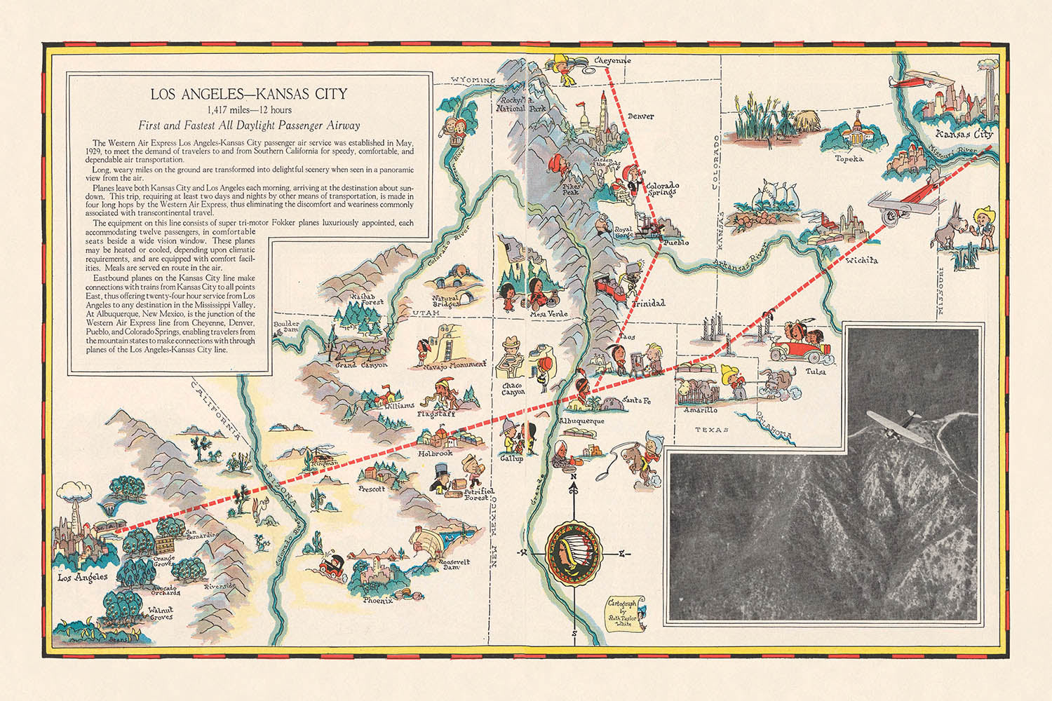
Adéntrese en la edad de oro de la aviación con este extraordinario mapa pictórico de 1929, «Los Angeles-Kansas City», creado por la célebre cartógrafa Ruth Taylor White para Western Air Express. Este mapa se erige como un vibrante testimonio del amanecer de los viajes aéreos comerciales en Estados Unidos, conmemorando la ruta inaugural diurna de pasajeros que abarcaba 1.417 millas desde Los Angeles hasta Kansas City. Más que una simple ayuda para la navegación, este mapa es una celebración del progreso tecnológico, que captura el espíritu de innovación y aventura que definió finales de la década de 1920. Ofrece una ventana única a una era transformadora, cuando cruzar el continente por aire en solo 12 horas no era menos que revolucionario.
El arte de Ruth Taylor White brilla en cada detalle, combinando cartografía informativa con ilustración caprichosa. La ruta se traza audazmente sobre el paisaje americano, salpicada de encantadoras representaciones de grandes ciudades como Los Angeles, Albuquerque, Amarillo y Kansas City. A lo largo del recorrido, el mapa destaca la diversa geografía del Oeste y el Medio Oeste estadounidenses, con montañas, ríos y bosques estilizados representados en colores vivos. Hitos notables, entre ellos el majestuoso Gran Cañón y el imponente río Colorado, cobran vida con encantadores adornos pictóricos, invitando al espectador a imaginar las vistas que aguardaban a los primeros viajeros aéreos.
Lo que realmente distingue a este mapa es la integración de temas culturales y recreativos, que refleja el atractivo multifacético de las regiones que recorre. Ilustraciones de deportes de invierno y verano, caza, pesca e industria local salpican el paisaje, mientras que escenas de la vida indígena estadounidense y de la agricultura regional evocan el rico tapiz del patrimonio americano. Estos elementos transforman el mapa en un relato visual de viaje, que ofrece tanto información práctica como una narrativa atractiva de descubrimiento. La inclusión de los tiempos de vuelo y las distancias entre paradas subraya además el doble papel del mapa como herramienta promocional y guía funcional para el pasajero pionero.
La importancia histórica de este mapa no puede exagerarse. Emitido en una época en que los viajes aéreos eran una novedad para la mayoría de los estadounidenses, fue diseñado para inspirar confianza y entusiasmo por este nuevo modo de transporte. El texto promocional del mapa, la rosa de los vientos adornada con el logotipo en forma de punta de flecha de Western Air Express y el eslogan «Travel by air» hablan de la optimismo y la ambición de la época. Es un documento que encapsula la rápida modernización de la nación, así como la audaz visión de quienes buscaron acortar distancias y conectar ciudades a través de los cielos.
Tanto los coleccionistas como los aficionados a la historia apreciarán el legado perdurable de la obra de Ruth Taylor White. Sus mapas son celebrados no solo por su precisión técnica, sino también por su capacidad para cautivar la imaginación. Esta pieza en particular, con su meticuloso detalle y su gozosa exuberancia, se erige a la vez como una obra de arte y un artefacto histórico. Ofrece una oportunidad excepcional de poseer un fragmento de la historia de la aviación: un mapa que en su día inspiró a los viajeros a emprender un viaje de velocidad, comodidad y descubrimiento a través del corazón de América.
Lugares en este mapa
- Los Angeles, California
- Kansas City, Missouri
- Albuquerque, New Mexico
- Winslow, Arizona
- Kingman, Arizona
- Amarillo, Texas
- Wichita, Kansas
- Santa Fe, New Mexico
- Grand Canyon (Arizona)
- Colorado River
- Rocky Mountains
- Mojave Desert (California)
- Montañas de San Bernardino (California)
- Needles, California
- Gallup, Nuevo México
- Tucumcari, Nuevo México
- Las Vegas, Nuevo México
- Santa Rosa, Nuevo México
- Dodge City, Kansas
- Hutchinson, Kansas
Características destacadas y puntos de interés
- La ruta aérea principal de Los Ángeles a Kansas City se muestra de forma destacada.
- Las principales ciudades a lo largo de la ruta están etiquetadas y representadas con iconos pictóricos.
- El logotipo de Western Air Express (punta de flecha) está presente, reforzando la identidad de marca.
- Se incluye una rosa de los vientos, con el motivo de punta de flecha.
- La ruta está marcada con distancias y tiempos de vuelo estimados entre las paradas clave.
- Representaciones pictóricas de montañas, bosques, ríos y tierras de cultivo se distribuyen a lo largo de la ruta.
- Se ilustran actividades recreativas como el esquí, la caza y la pesca.
- Los sitios industriales y las zonas agrícolas se representan con iconos pertinentes (fábricas, granjas).
- Hitos notables, como el Gran Cañón, se ilustran y etiquetan.
- El mapa incluye ilustraciones de figuras indígenas americanas y escenas culturales.
- Ríos como el río Colorado se muestran y etiquetan claramente.
- Las Montañas Rocosas se representan de manera estilizada y pictórica.
- El mapa incluye ilustraciones caprichosas de animales y actividades regionales.
- Los límites estatales se muestran, con los nombres de los estados etiquetados.
- El lema “Viaje por aire” se incluye como parte del mensaje promocional.
- El mapa está orientado de oeste a este, siguiendo la dirección de la ruta aérea.
- El estilo pictórico enfatiza tanto la belleza natural como el progreso moderno.
- El mapa destaca la novedad y la emoción del viaje aéreo a finales de la década de 1920.
Contexto histórico y de diseño
- Nombre del mapa: Los Ángeles-Kansas City, creado como parte de un folleto de Western Air Express.
- Fecha de creación: octubre de 1929.
- Cartógrafa: Ruth Taylor White, una destacada creadora de mapas conocida por sus mapas pictóricos y temáticos a comienzos del siglo XX.
- Editor: Western Air Express, una de las primeras aerolíneas comerciales de Estados Unidos.
- Producción destinada a ilustrar y promocionar las rutas inaugurales de pasajeros por aire entre Los Ángeles y Kansas City.
- Conmemora el lanzamiento de la primera y más rápida ruta aérea de pasajeros de todo el día con luz natural, reflejando el rápido crecimiento y la innovación en la aviación comercial durante finales de la década de 1920.
- Contexto del folleto: Este mapa fue uno de los cuatro mapas pictóricos de ruta de doble página incluidos en un folleto de viaje litografiado, que también presentaba rutas de San Francisco a Los Ángeles, de Los Ángeles a Tijuana/Agua Caliente y de Los Ángeles a Salt Lake City.
- Estilo del mapa: Temático y pictórico, con el relieve representado de forma pictórica; hitos, bosques, ríos, montañas y lugares de recreo se ilustran en un estilo colorido y atractivo.
- Elementos de diseño: Presenta una rosa de los vientos con un logotipo de punta de flecha, reforzando el espíritu pionero de la aerolínea.
- Temas representados: Rutas de viaje aéreo, tiempos de vuelo y distancias, características geográficas (montañas, ríos, bosques), actividades recreativas, sitios industriales y lugares de interés.
- Distancia y tiempo de viaje: La ruta recorre 1.417 millas y podía volarse en 12 horas, un logro significativo para la época.
- Enfoque promocional: Destaca la velocidad, la comodidad y la fiabilidad del viaje aéreo, con el objetivo de atraer nuevos pasajeros a la aviación comercial.
- Importancia histórica: Sirve como testimonio de los primeros tiempos de la aviación comercial y del desarrollo de las redes de transporte aéreo en EE. UU.
- Contexto cultural: Refleja el optimismo y el espíritu innovador de los años 20, así como la creciente importancia del turismo y los viajes.
- Enfoque artístico: Utiliza ilustraciones coloridas, de estilo caricaturesco, para hacer que el mapa sea accesible y atractivo para el público.
- Destaca por: Integrar información práctica de viaje con elementos artísticos y promocionales.
- Audiencia: Dirigido a posibles viajeros aéreos, turistas y al público en general interesado en el transporte moderno.
- Legado: Los mapas de Ruth Taylor White se consideran ahora documentos históricos valiosos y de coleccionista.
Por favor, compruebe detenidamente las imágenes para asegurarse de que este mapa muestra una ciudad o lugar específico. También puede ponerse en contacto con nosotros y pedirnos que revisemos el mapa por usted.
Este mapa queda estupendo en cualquier tamaño, pero siempre recomiendo elegir un tamaño mayor si dispone de espacio. Así podrá apreciar fácilmente todos los detalles.
Este mapa luce increíble en tamaños de hasta 70in (180cm). Si está buscando un mapa más grande, por favor póngase en contacto.
El modelo en las imágenes del anuncio sostiene la versión de 24x36in (60x90cm) de este mapa.
La quinta imagen del anuncio muestra un ejemplo de mi servicio de personalización de mapas.
Si busca algo ligeramente diferente, consulte mi colección de los mejores mapas antiguos para ver si algo más le llama la atención.
Por favor, contácteme para comprobar si una determinada ubicación, hito o elemento aparece en este mapa.
Sería un regalo maravilloso de cumpleaños, Navidad, Día del Padre, despedida del trabajo, aniversario o inauguración de casa para alguien de las zonas cubiertas por este mapa.
Este mapa está disponible como impresión giclée sobre papel mate de archivo libre de ácido, o puede adquirirlo enmarcado. El marco es un bonito y sencillo marco negro que combina con la mayoría de estilos. Póngase en contacto si desea un color o material de marco diferente. Mis marcos llevan acristalamiento de acrílico de calidad museo, ultraclaro (perspex/acrylite), que es considerablemente menos reflectante que el vidrio, más seguro y siempre llegará en perfectas condiciones.
This map is also available as a float framed canvas, sometimes known as a shadow gap framed canvas or canvas floater. The map is printed on artist's cotton canvas and then stretched over a handmade box frame. We then "float" the canvas inside a wooden frame, which is available in a range of colours (black, dark brown, oak, antique gold and white). This is a wonderful way to present a map without glazing in front. See some examples of float framed canvas maps and explore the differences between my different finishes.
For something truly unique, this map is also available in "Unique 3D", our trademarked process that dramatically transforms the map so that it has a wonderful sense of depth. We combine the original map with detailed topography and elevation data, so that mountains and the terrain really "pop". For more info and examples of 3D maps, check my Unique 3D page.
Many of our maps and art prints are chosen as thoughtful gifts for homes, offices, studies and meaningful places.
Choose a framed option for the easiest ready-to-hang gift, or choose an unframed print if the recipient may prefer to select their own frame.
We make orders locally in 23 countries around the world, so gifts can often be produced close to the recipient. This helps them arrive faster, travel more safely, and avoid customs or import duty surprises.
- We can deliver directly to the recipient
- Framed pieces arrive ready to hang
- Unframed prints are carefully packed in a strong protective tube
- Almost every order is made locally, for faster, safer gifting
- 90-day returns give the recipient time to decide
If you are not sure what to choose, please contact us. We can help you pick the right map, size, finish or delivery option.
Para la mayoría de los pedidos, el tiempo de entrega es de aproximadamente 3 días laborables. Los productos personalizados y a medida tardan más, ya que tengo que hacer la personalización y enviártelo para su aprobación, lo cual suele tardar 1 o 2 días.
Tenga en cuenta que los pedidos enmarcados muy grandes suelen tardar más en fabricarse y entregarse.
Si necesitas que tu pedido llegue para una fecha determinada, por favor contáctame antes de hacer el pedido para que podamos encontrar la mejor manera de asegurarnos de que recibas tu pedido a tiempo.
Imprimo y enmarco mapas y obras de arte en 23 países alrededor del mundo. Esto significa que tu pedido se fabricará localmente, lo que reduce el tiempo de entrega y asegura que no se dañe durante el envío. Nunca pagarás aranceles de aduana o impuestos de importación, y pondremos menos CO2 en el aire.
Todos mis mapas y impresiones artísticas están bien empaquetados y enviados en un tubo resistente si no están enmarcados, o rodeados de espuma si están enmarcados.
Intento enviar todos los pedidos dentro de 1 o 2 días después de recibir tu pedido, aunque algunos productos (como mascarillas, tazas y bolsas de tela) pueden tardar más en fabricarse.
Si seleccionas Entrega Exprés al finalizar la compra, priorizaremos tu pedido y lo enviaremos por mensajería de 1 día (Fedex, DHL, UPS, Parcelforce).
La entrega al día siguiente también está disponible en algunos países (EE. UU., Reino Unido, Singapur, EAU), pero por favor intenta hacer tu pedido temprano en el día para que podamos enviarlo a tiempo.
Mi marco estándar es un marco de madera de fresno negro estilo galería. Es simple y tiene un aspecto bastante moderno. Mi marco estándar tiene alrededor de 20 mm (0.8 in) de ancho.
Utilizo acrílico super claro (perspex/acrylite) para el vidrio del marco. Es más ligero y seguro que el vidrio, y se ve mejor, ya que la reflectividad es menor.
Seis colores de marco estándar están disponibles de forma gratuita (negro, marrón oscuro, gris oscuro, roble, blanco y oro antiguo).El enmarcado y montaje/matizado personalizado está disponible si buscas algo diferente.
La mayoría de los mapas, arte e ilustraciones también están disponibles como un lienzo enmarcado. Utilizamos lienzo de algodón mate (no brillante), lo estiramos sobre un marco de madera de caja de origen sostenible, y luego 'flotamos' la pieza dentro de un marco de madera. El resultado final es bastante hermoso, y no hay cristal que se interponga.
Todos los marcos se proporcionan "listos para colgar", con una cuerda o soportes en la parte posterior. Los marcos muy grandes tendrán placas de colgar de alta resistencia y/o un listón de montaje. Si tienes alguna pregunta, por favor ponte en contacto.
Mira algunos ejemplos de mis mapas enmarcados y mapas en lienzo enmarcados.
Alternativamente, también puedo proporcionar mapas antiguos y obras de arte en lienzo, tablero de espuma, papel de algodón y otros materiales.
Si deseas enmarcar tu mapa o obra de arte tú mismo, por favor lee mi guía de tamaños primero.
Mis mapas son reproducciones de mapas originales de altísima calidad.
Obtengo mapas originales y raros de bibliotecas, casas de subastas y colecciones privadas de todo el mundo, los restauro en mi taller de Londres y luego uso tintas e impresoras giclée especializadas para crear hermosos mapas que lucen incluso mejor que el original.
Mis mapas están impresos en papel de archivo mate (no brillante) sin ácido que se siente de muy alta calidad y casi como una tarjeta. En términos técnicos, el peso/grosor del papel es de 10 mil/200 g/m². Es perfecto para enmarcar.
Imprimo con tintas pigmentadas Epson ultrachrome giclée UV resistentes a la decoloración, algunas de las mejores tintas que puedes encontrar.
yo también puedo hacer mapas sobre lienzo, trapo de algodón y otros materiales exóticos.
Obtenga más información sobre The Unique Maps Co..
Personalización de mapas
Si está buscando el regalo perfecto de aniversario o inauguración de la casa, puedo personalizar su mapa para hacerlo verdaderamente único. Por ejemplo, puedo agregar un mensaje corto, resaltar una ubicación importante o agregar el escudo de armas de su familia.
Las opciones son casi infinitas. Por favor mira mi página de personalización de mapas para ver algunos maravillosos ejemplos de lo que es posible.
Para pedir un mapa personalizado, seleccione "personalizar su mapa" antes de agregarlo a su carrito.
Ponerse en contacto si buscas personalizaciones y personalizaciones más complejas.
Envejecimiento del mapa
A lo largo de los años, los clientes me han preguntado cientos de veces si podían comprar un mapa que se viera uniforme. más viejo.
Bueno, ahora puedes hacerlo seleccionando Envejecido antes de agregar un mapa a tu carrito.
Todas las fotografías de productos que ve en esta página muestran el mapa en su forma original. Así es como se ve el mapa hoy.
Si selecciona Envejecido, envejeceré su mapa a mano, usando un proceso especial y único desarrollado a través de años de estudiar mapas antiguos, hablar con investigadores para comprender la química del envejecimiento del papel y, por supuesto... ¡mucha práctica!
Si no estás seguro, quédate con el color original del mapa. Si quieres algo un poco más oscuro y más viejo buscando, opte por Envejecido.
Si no estás satisfecho con tu pedido por cualquier motivo, contáctame para un reembolso sin complicaciones. Por favor, consulta nuestra política de devoluciones y reembolsos para más información.
Estoy muy seguro de que te gustará tu mapa o impresión artística restaurada. He estado haciendo esto desde 1984. Soy un vendedor de 5 estrellas en Etsy. He vendido decenas de miles de mapas e impresiones artísticas y tengo más de 5,000 opiniones reales de 5 estrellas.
Utilizo un proceso único para restaurar mapas y obras de arte que consume mucho tiempo y mano de obra. Buscar los mapas e ilustraciones originales puede llevar meses. Utilizo tecnología de última generación y extremadamente cara para escanear y restaurarlos. Como resultado, garantizo que mis mapas e impresiones artísticas son superiores a los demás - por eso puedo ofrecer un reembolso sin complicaciones.
Casi todos mis mapas e impresiones artísticas se ven increíbles en tamaños grandes (200cm, 6.5ft+) y también puedo enmarcarlos y entregártelos a través de un servicio de mensajería especial para tamaños grandes. Contáctame para discutir tus necesidades específicas.
Or try searching for something!


