


Rare Old Map of Perth, Scotland by Rapkin, 1851: River Tay, North Inch, South Inch, High Street, Tay Street
La oferta del coleccionista
Elija dos obras elegibles y obtenga un 20 % de descuento en ambas. Elija tres y la de menor precio será gratuita, con un ahorro máximo del 33 %.
Combine y mezcle mapas estándar elegibles y reproducciones de bellas artes. No se requiere código; la oferta se aplica automáticamente al finalizar la compra.
Se incluyen las configuraciones estándar hechas por encargo. Quedan excluidos los tamaños a medida, los diseños personalizados y los trabajos por encargo.
¿Necesita entrega en diferentes direcciones? Contáctenos antes de realizar el pedido.La oferta del coleccionista
Elija dos obras elegibles y obtenga un 20 % de descuento en ambas. Elija tres y la de menor precio será gratuita, con un ahorro máximo del 33 %.
Combine y mezcle mapas estándar elegibles y reproducciones de bellas artes. No se requiere código; la oferta se aplica automáticamente al finalizar la compra.
Se incluyen las configuraciones estándar hechas por encargo. Quedan excluidos los tamaños a medida, los diseños personalizados y los trabajos por encargo.
¿Necesita entrega en diferentes direcciones? Contáctenos antes de realizar el pedido. Restaurado en Londres • Hecho en the UK

Restaurado a partir del mapa original de 1851 e impreso en calidad museo. Leer la historia detrás de este mapa
Choose your size
Choose your finish


(Más información)
Mensaje de regalo y acabado personalizado

Si deseas agregar un mensaje de regalo, o un acabado (rompecabezas, tablero de aluminio, etc.) que no esté disponible aquí, por favor solicítalo en la "nota del pedido" cuando realices la compra.
Cada pedido es hecho a medida, así que si necesitas que el tamaño se ajuste ligeramente, o que se imprima en un material inusual, háznoslo saber. Hemos realizado miles de pedidos personalizados a lo largo de los años, así que hay (casi) nada que no podamos gestionar.
También puedes contactarnos antes de hacer tu pedido, ¡si lo prefieres!

- Hecho localmente. Entrega segura
- Sin aranceles ni cargos ocultos
- ¿Necesitas ayuda? Llámanos o mensaje por WhatsApp
Own a piece of history
8,000+ five-star reviews


Titled simply “Perth,” this 1851 town plan by J. Rapkin for John Tallis & Company distills the Fair City at a moment...
Seguir leyendoTitled simply “Perth,” this 1851 town plan by J. Rapkin for John Tallis & Company distills the Fair City at a moment of confident mid-Victorian poise. It is a classic Tallis synthesis: a crisply engraved street plan encircled by elegant lettering and decorative cartouches, enlivened by pictorial views of the surrounding landscape. The River Tay—Scotland’s longest—anchors the composition, its broad sweep defining the city’s lineaments and commerce. As a city map, it is especially compelling for how it blends utility with romance: practical annotations of thoroughfares and key buildings paired with vignettes that stage Perth against its hills and water-meadows. The result is both a guide to movement and a portrait of civic identity shaped by river, bridge, and green.
At street level, the plan captures the city’s classic spine-and-river arrangement. High Street—articulated as East High Street and West High Street—runs true as Perth’s mercantile corridor, intersected by Mill Street and Market Street and fed by North Street and South Street. Tay Street tracks the waterfront’s working edge, while Canal Street, Castle Street, and Miln Street compass the dense core. Beyond the historic center, Leonard Street and Wilson Street express orderly expansion, and approaches like Craigie Road and Letham Street signal growing suburban reach. The engraver’s deft labeling of notable buildings gives the urban fabric depth: civic halls, ecclesiastical towers, and commercial houses form a cadence of landmarks that orient the eye and narrate the city’s public life.
Green space is Perth’s signature flourish, and the map sets it off with clarity and grace. The North Inch and South Inch—broad, level meadows long cherished as communal grounds—bookend the urban front along the Tay, their openness dramatizing the river’s breadth and the town’s restraint. Notchty Island punctuates the stream, a mid-channel accent that helps explain the Tay’s braided flow at Perth. Together, the Inches and river read as both amenity and infrastructure: places of recreation, parade, and pasture that also double as natural floodplain and civic stage. The careful plotting of Tay Street opposite these greenswards hints at a proto-promenade sensibility, where trade, travel, and leisure coexisted at the water’s edge.
Rapkin’s composition sets the town against its hinterland with rare pictorial tact. The illustrated landscapes present soft horizons and wooded slopes that frame the city without overwhelming it, underscoring Perth’s role as gateway between Lowlands and Highlands. Outlying names—Cherrybank to the west, Tullybelton Road striking north—trace the city’s ties to estates, farms, and upland routes. College Place and Craigie Road suggest scholastic and residential precincts budding beyond the medieval core, while Castle Street preserves a memory of fortified authority within a modernizing grid. The effect is of a place in balanced transition: old burghal textures giving way to planned avenues, yet still reading as one coherent organism shaped by river, meadow, and trade.
The Tallis-Rapkin partnership is itself part of the map’s allure. John Tallis & Company, publishing from London and New York, perfected the mid-19th-century art-map: engraved plans precise enough for the traveller, but ornamented—through cartouches, borders, and vignettes—to satisfy the collector. Rapkin’s hallmark is evident in the legibility of every line and the measured hierarchy of type, a town plan arranged with almost gazetteer-like clarity. In Perth, their method achieves something especially notable for a city map: it balances topographic fidelity with a painterly sense of place. You see not only where streets and buildings stand, but why the city stands here—and how river, greensward, and road have conspired to make it thrive.
Streets and roads on this map
- Canal Street
- Castle Street
- Cherrybank
- College Place
- Craigie Road
- East High Street
- High Street
- Hight Street
- Letham Street
- Leonard Street
- Market Street
- Miln Street
- Mill Street
- North Street
- North Inch
- South Inch
- South Street
- Tay Street
- Tullybelton Road
- West High Street
- Wilson Street
Notable Features & Landmarks
- Image of the River Tay
- Illustrations of nearby landscapes
- Locations of notable buildings
- Northern and Southern Inches
- Notchty Island
Historical and design context
- Created in 1851 by Tallis & Rapkin; published by John Tallis & Company (London & New York).
- Combines engraved mapping with lithographed images; features ornate lettering and decorative cartouches typical of the era.
- Hand-colored with outline coloring.
- Rapkin’s town plans often carry estimated dates.
- Issued with a complete Index/Gazetteer, bound in a separate volume from the maps.
- Reflects a mid-19th-century trend that treated cartography as both utilitarian and decorative (fine art).
Please double check the images to make sure that a specific town or place is shown on this map. You can also get in touch and ask us to check the map for you.
This map looks great at every size, but I always recommend going for a larger size if you have space. That way you can easily make out all of the details.
This map looks amazing at sizes all the way up to 50in (125cm). If you are looking for a larger map, please get in touch.
The model in the listing images is holding the 18x24in (45x60cm) version of this map.
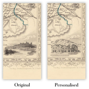
The fifth listing image shows an example of my map personalisation service.
If you’re looking for something slightly different, check out my collection of the best old maps to see if something else catches your eye.
Please contact me to check if a certain location, landmark or feature is shown on this map.
This would make a wonderful birthday, Christmas, Father's Day, work leaving, anniversary or housewarming gift for someone from the areas covered by this map.
This map is available as a giclée print on acid free archival matte paper, or you can buy it framed. The frame is a nice, simple black frame that suits most aesthetics. Please get in touch if you'd like a different frame colour or material. My frames are glazed with super-clear museum-grade acrylic (perspex/acrylite), which is significantly less reflective than glass, safer, and will always arrive in perfect condition.
This map is also available as a float framed canvas, sometimes known as a shadow gap framed canvas or canvas floater. The map is printed on artist's cotton canvas and then stretched over a handmade box frame. We then "float" the canvas inside a wooden frame, which is available in a range of colours (black, dark brown, oak, antique gold and white). This is a wonderful way to present a map without glazing in front. See some examples of float framed canvas maps and explore the differences between my different finishes.
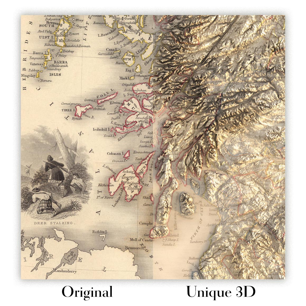
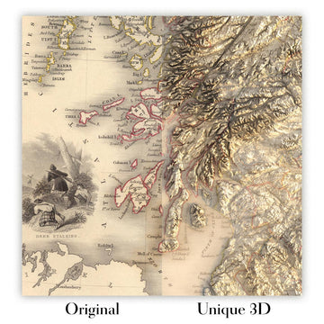
For something truly unique, this map is also available in "Unique 3D", our trademarked process that dramatically transforms the map so that it has a wonderful sense of depth. We combine the original map with detailed topography and elevation data, so that mountains and the terrain really "pop". For more info and examples of 3D maps, check my Unique 3D page.
Titled simply “Perth,” this 1851 town plan by J. Rapkin for John Tallis & Company distills the Fair City at a moment of confident mid-Victorian poise. It is a classic Tallis synthesis: a crisply engraved street plan encircled by elegant lettering and decorative cartouches, enlivened by pictorial views of the surrounding landscape. The River Tay—Scotland’s longest—anchors the composition, its broad sweep defining the city’s lineaments and commerce. As a city map, it is especially compelling for how it blends utility with romance: practical annotations of thoroughfares and key buildings paired with vignettes that stage Perth against its hills and water-meadows. The result is both a guide to movement and a portrait of civic identity shaped by river, bridge, and green.
At street level, the plan captures the city’s classic spine-and-river arrangement. High Street—articulated as East High Street and West High Street—runs true as Perth’s mercantile corridor, intersected by Mill Street and Market Street and fed by North Street and South Street. Tay Street tracks the waterfront’s working edge, while Canal Street, Castle Street, and Miln Street compass the dense core. Beyond the historic center, Leonard Street and Wilson Street express orderly expansion, and approaches like Craigie Road and Letham Street signal growing suburban reach. The engraver’s deft labeling of notable buildings gives the urban fabric depth: civic halls, ecclesiastical towers, and commercial houses form a cadence of landmarks that orient the eye and narrate the city’s public life.
Green space is Perth’s signature flourish, and the map sets it off with clarity and grace. The North Inch and South Inch—broad, level meadows long cherished as communal grounds—bookend the urban front along the Tay, their openness dramatizing the river’s breadth and the town’s restraint. Notchty Island punctuates the stream, a mid-channel accent that helps explain the Tay’s braided flow at Perth. Together, the Inches and river read as both amenity and infrastructure: places of recreation, parade, and pasture that also double as natural floodplain and civic stage. The careful plotting of Tay Street opposite these greenswards hints at a proto-promenade sensibility, where trade, travel, and leisure coexisted at the water’s edge.
Rapkin’s composition sets the town against its hinterland with rare pictorial tact. The illustrated landscapes present soft horizons and wooded slopes that frame the city without overwhelming it, underscoring Perth’s role as gateway between Lowlands and Highlands. Outlying names—Cherrybank to the west, Tullybelton Road striking north—trace the city’s ties to estates, farms, and upland routes. College Place and Craigie Road suggest scholastic and residential precincts budding beyond the medieval core, while Castle Street preserves a memory of fortified authority within a modernizing grid. The effect is of a place in balanced transition: old burghal textures giving way to planned avenues, yet still reading as one coherent organism shaped by river, meadow, and trade.
The Tallis-Rapkin partnership is itself part of the map’s allure. John Tallis & Company, publishing from London and New York, perfected the mid-19th-century art-map: engraved plans precise enough for the traveller, but ornamented—through cartouches, borders, and vignettes—to satisfy the collector. Rapkin’s hallmark is evident in the legibility of every line and the measured hierarchy of type, a town plan arranged with almost gazetteer-like clarity. In Perth, their method achieves something especially notable for a city map: it balances topographic fidelity with a painterly sense of place. You see not only where streets and buildings stand, but why the city stands here—and how river, greensward, and road have conspired to make it thrive.
Streets and roads on this map
- Canal Street
- Castle Street
- Cherrybank
- College Place
- Craigie Road
- East High Street
- High Street
- Hight Street
- Letham Street
- Leonard Street
- Market Street
- Miln Street
- Mill Street
- North Street
- North Inch
- South Inch
- South Street
- Tay Street
- Tullybelton Road
- West High Street
- Wilson Street
Notable Features & Landmarks
- Image of the River Tay
- Illustrations of nearby landscapes
- Locations of notable buildings
- Northern and Southern Inches
- Notchty Island
Historical and design context
- Created in 1851 by Tallis & Rapkin; published by John Tallis & Company (London & New York).
- Combines engraved mapping with lithographed images; features ornate lettering and decorative cartouches typical of the era.
- Hand-colored with outline coloring.
- Rapkin’s town plans often carry estimated dates.
- Issued with a complete Index/Gazetteer, bound in a separate volume from the maps.
- Reflects a mid-19th-century trend that treated cartography as both utilitarian and decorative (fine art).
Please double check the images to make sure that a specific town or place is shown on this map. You can also get in touch and ask us to check the map for you.
This map looks great at every size, but I always recommend going for a larger size if you have space. That way you can easily make out all of the details.
This map looks amazing at sizes all the way up to 50in (125cm). If you are looking for a larger map, please get in touch.
The model in the listing images is holding the 18x24in (45x60cm) version of this map.
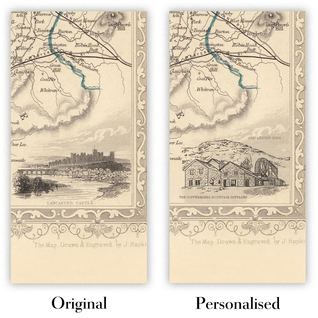
The fifth listing image shows an example of my map personalisation service.
If you’re looking for something slightly different, check out my collection of the best old maps to see if something else catches your eye.
Please contact me to check if a certain location, landmark or feature is shown on this map.
This would make a wonderful birthday, Christmas, Father's Day, work leaving, anniversary or housewarming gift for someone from the areas covered by this map.
This map is available as a giclée print on acid free archival matte paper, or you can buy it framed. The frame is a nice, simple black frame that suits most aesthetics. Please get in touch if you'd like a different frame colour or material. My frames are glazed with super-clear museum-grade acrylic (perspex/acrylite), which is significantly less reflective than glass, safer, and will always arrive in perfect condition.
This map is also available as a float framed canvas, sometimes known as a shadow gap framed canvas or canvas floater. The map is printed on artist's cotton canvas and then stretched over a handmade box frame. We then "float" the canvas inside a wooden frame, which is available in a range of colours (black, dark brown, oak, antique gold and white). This is a wonderful way to present a map without glazing in front. See some examples of float framed canvas maps and explore the differences between my different finishes.
For something truly unique, this map is also available in "Unique 3D", our trademarked process that dramatically transforms the map so that it has a wonderful sense of depth. We combine the original map with detailed topography and elevation data, so that mountains and the terrain really "pop". For more info and examples of 3D maps, check my Unique 3D page.
Many of our maps and art prints are chosen as thoughtful gifts for homes, offices, studies and meaningful places.
Choose a framed option for the easiest ready-to-hang gift, or choose an unframed print if the recipient may prefer to select their own frame.
We make orders locally in 23 countries around the world, so gifts can often be produced close to the recipient. This helps them arrive faster, travel more safely, and avoid customs or import duty surprises.
- We can deliver directly to the recipient
- Framed pieces arrive ready to hang
- Unframed prints are carefully packed in a strong protective tube
- Almost every order is made locally, for faster, safer gifting
- 90-day returns give the recipient time to decide
If you are not sure what to choose, please contact us. We can help you pick the right map, size, finish or delivery option.
Para la mayoría de los pedidos, el tiempo de entrega es de aproximadamente 3 días laborables. Los productos personalizados y a medida tardan más, ya que tengo que hacer la personalización y enviártelo para su aprobación, lo cual suele tardar 1 o 2 días.
Tenga en cuenta que los pedidos enmarcados muy grandes suelen tardar más en fabricarse y entregarse.
Si necesitas que tu pedido llegue para una fecha determinada, por favor contáctame antes de hacer el pedido para que podamos encontrar la mejor manera de asegurarnos de que recibas tu pedido a tiempo.
Imprimo y enmarco mapas y obras de arte en 23 países alrededor del mundo. Esto significa que tu pedido se fabricará localmente, lo que reduce el tiempo de entrega y asegura que no se dañe durante el envío. Nunca pagarás aranceles de aduana o impuestos de importación, y pondremos menos CO2 en el aire.
Todos mis mapas y impresiones artísticas están bien empaquetados y enviados en un tubo resistente si no están enmarcados, o rodeados de espuma si están enmarcados.
Intento enviar todos los pedidos dentro de 1 o 2 días después de recibir tu pedido, aunque algunos productos (como mascarillas, tazas y bolsas de tela) pueden tardar más en fabricarse.
Si seleccionas Entrega Exprés al finalizar la compra, priorizaremos tu pedido y lo enviaremos por mensajería de 1 día (Fedex, DHL, UPS, Parcelforce).
La entrega al día siguiente también está disponible en algunos países (EE. UU., Reino Unido, Singapur, EAU), pero por favor intenta hacer tu pedido temprano en el día para que podamos enviarlo a tiempo.
Mi marco estándar es un marco de madera de fresno negro estilo galería. Es simple y tiene un aspecto bastante moderno. Mi marco estándar tiene alrededor de 20 mm (0.8 in) de ancho.
Utilizo acrílico super claro (perspex/acrylite) para el vidrio del marco. Es más ligero y seguro que el vidrio, y se ve mejor, ya que la reflectividad es menor.
Seis colores de marco estándar están disponibles de forma gratuita (negro, marrón oscuro, gris oscuro, roble, blanco y oro antiguo).El enmarcado y montaje/matizado personalizado está disponible si buscas algo diferente.
La mayoría de los mapas, arte e ilustraciones también están disponibles como un lienzo enmarcado. Utilizamos lienzo de algodón mate (no brillante), lo estiramos sobre un marco de madera de caja de origen sostenible, y luego 'flotamos' la pieza dentro de un marco de madera. El resultado final es bastante hermoso, y no hay cristal que se interponga.
Todos los marcos se proporcionan "listos para colgar", con una cuerda o soportes en la parte posterior. Los marcos muy grandes tendrán placas de colgar de alta resistencia y/o un listón de montaje. Si tienes alguna pregunta, por favor ponte en contacto.
Mira algunos ejemplos de mis mapas enmarcados y mapas en lienzo enmarcados.
Alternativamente, también puedo proporcionar mapas antiguos y obras de arte en lienzo, tablero de espuma, papel de algodón y otros materiales.
Si deseas enmarcar tu mapa o obra de arte tú mismo, por favor lee mi guía de tamaños primero.
Mis mapas son reproducciones de mapas originales de altísima calidad.
Obtengo mapas originales y raros de bibliotecas, casas de subastas y colecciones privadas de todo el mundo, los restauro en mi taller de Londres y luego uso tintas e impresoras giclée especializadas para crear hermosos mapas que lucen incluso mejor que el original.
Mis mapas están impresos en papel de archivo mate (no brillante) sin ácido que se siente de muy alta calidad y casi como una tarjeta. En términos técnicos, el peso/grosor del papel es de 10 mil/200 g/m². Es perfecto para enmarcar.
Imprimo con tintas pigmentadas Epson ultrachrome giclée UV resistentes a la decoloración, algunas de las mejores tintas que puedes encontrar.
yo también puedo hacer mapas sobre lienzo, trapo de algodón y otros materiales exóticos.
Obtenga más información sobre The Unique Maps Co..
Personalización de mapas
Si está buscando el regalo perfecto de aniversario o inauguración de la casa, puedo personalizar su mapa para hacerlo verdaderamente único. Por ejemplo, puedo agregar un mensaje corto, resaltar una ubicación importante o agregar el escudo de armas de su familia.
Las opciones son casi infinitas. Por favor mira mi página de personalización de mapas para ver algunos maravillosos ejemplos de lo que es posible.
Para pedir un mapa personalizado, seleccione "personalizar su mapa" antes de agregarlo a su carrito.
Ponerse en contacto si buscas personalizaciones y personalizaciones más complejas.
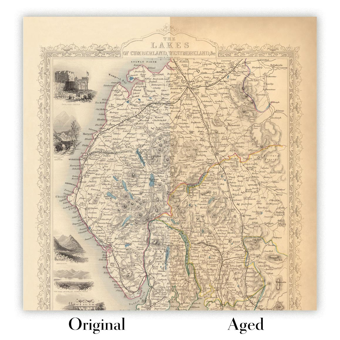
Envejecimiento del mapa
A lo largo de los años, los clientes me han preguntado cientos de veces si podían comprar un mapa que se viera uniforme. más viejo.
Bueno, ahora puedes hacerlo seleccionando Envejecido antes de agregar un mapa a tu carrito.
Todas las fotografías de productos que ve en esta página muestran el mapa en su forma original. Así es como se ve el mapa hoy.
Si selecciona Envejecido, envejeceré su mapa a mano, usando un proceso especial y único desarrollado a través de años de estudiar mapas antiguos, hablar con investigadores para comprender la química del envejecimiento del papel y, por supuesto... ¡mucha práctica!
Si no estás seguro, quédate con el color original del mapa. Si quieres algo un poco más oscuro y más viejo buscando, opte por Envejecido.
Si no estás satisfecho con tu pedido por cualquier motivo, contáctame para un reembolso sin complicaciones. Por favor, consulta nuestra política de devoluciones y reembolsos para más información.
Estoy muy seguro de que te gustará tu mapa o impresión artística restaurada. He estado haciendo esto desde 1984. Soy un vendedor de 5 estrellas en Etsy. He vendido decenas de miles de mapas e impresiones artísticas y tengo más de 5,000 opiniones reales de 5 estrellas.
Utilizo un proceso único para restaurar mapas y obras de arte que consume mucho tiempo y mano de obra. Buscar los mapas e ilustraciones originales puede llevar meses. Utilizo tecnología de última generación y extremadamente cara para escanear y restaurarlos. Como resultado, garantizo que mis mapas e impresiones artísticas son superiores a los demás - por eso puedo ofrecer un reembolso sin complicaciones.
Casi todos mis mapas e impresiones artísticas se ven increíbles en tamaños grandes (200cm, 6.5ft+) y también puedo enmarcarlos y entregártelos a través de un servicio de mensajería especial para tamaños grandes. Contáctame para discutir tus necesidades específicas.
Or try searching for something!


