

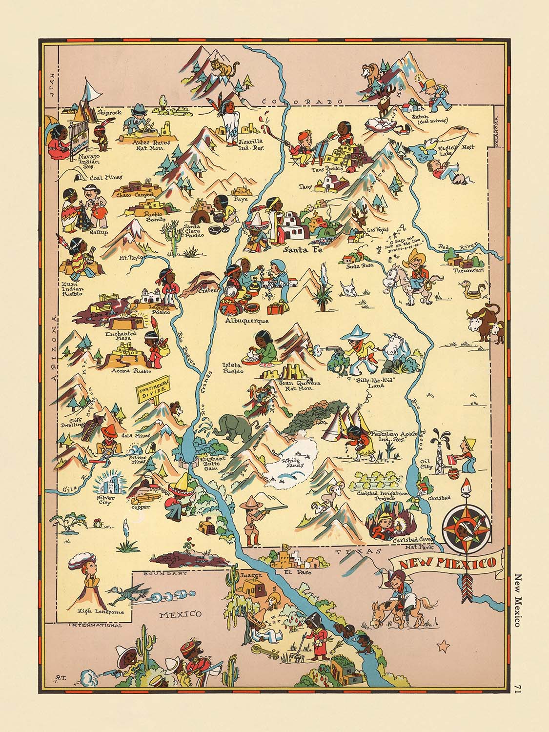


Mapa pictórico de Nuevo México de Ruth Taylor White, 1935: Albuquerque, Santa Fe, Río Grande, Cavernas de Carlsbad, Bosque Nacional Gila
La oferta del coleccionista
Elija dos obras elegibles y obtenga un 20 % de descuento en ambas. Elija tres y la de menor precio será gratuita, con un ahorro máximo del 33 %.
Combine y mezcle mapas estándar elegibles y reproducciones de bellas artes. No se requiere código; la oferta se aplica automáticamente al finalizar la compra.
Se incluyen las configuraciones estándar hechas por encargo. Quedan excluidos los tamaños a medida, los diseños personalizados y los trabajos por encargo.
¿Necesita entrega en diferentes direcciones? Contáctenos antes de realizar el pedido.La oferta del coleccionista
Elija dos obras elegibles y obtenga un 20 % de descuento en ambas. Elija tres y la de menor precio será gratuita, con un ahorro máximo del 33 %.
Combine y mezcle mapas estándar elegibles y reproducciones de bellas artes. No se requiere código; la oferta se aplica automáticamente al finalizar la compra.
Se incluyen las configuraciones estándar hechas por encargo. Quedan excluidos los tamaños a medida, los diseños personalizados y los trabajos por encargo.
¿Necesita entrega en diferentes direcciones? Contáctenos antes de realizar el pedido. Restaurado en Londres • Hecho en the UK

Restaurado a partir del mapa original de 1935 e impreso en calidad museo. Leer la historia detrás de este mapa
Choose your size
Choose your finish


(Más información)
Mensaje de regalo y acabado personalizado

Si deseas agregar un mensaje de regalo, o un acabado (rompecabezas, tablero de aluminio, etc.) que no esté disponible aquí, por favor solicítalo en la "nota del pedido" cuando realices la compra.
Cada pedido es hecho a medida, así que si necesitas que el tamaño se ajuste ligeramente, o que se imprima en un material inusual, háznoslo saber. Hemos realizado miles de pedidos personalizados a lo largo de los años, así que hay (casi) nada que no podamos gestionar.
También puedes contactarnos antes de hacer tu pedido, ¡si lo prefieres!

- Hecho localmente. Entrega segura
- Sin aranceles ni cargos ocultos
- ¿Necesitas ayuda? Llámanos o mensaje por WhatsApp
Own a piece of history
8,000+ five-star reviews


Adéntrese en el vibrante tapiz del suroeste estadounidense con “New Mexico”, un cautivador mapa pictórico originalmente elaborado en 1935 por la célebre...
Seguir leyendoAdéntrese en el vibrante tapiz del suroeste estadounidense con “New Mexico”, un cautivador mapa pictórico originalmente elaborado en 1935 por la célebre cartógrafa Ruth Taylor White. Este encantador mapa destaca dentro de la serie de atlas caprichosos de White, donde cada estado cobra vida a través de un caleidoscopio de color, humor y aguda observación. El título original, “New Mexico”, refleja tanto el enfoque geográfico como el espíritu creativo de la época, invitando al espectador a explorar la Tierra del Encantamiento tal como se percibía a principios del siglo XX. El enfoque de White transforma la cartografía tradicional en una atractiva narración visual, combinando arte y precisión geográfica.
El legado de Ruth Taylor White como creadora de mapas es inseparable de su estilo único: sus mapas son reconocibles al instante por sus ilustraciones juguetonas, de aire caricaturesco, y su meticulosa atención al carácter regional. La obra de White trasciende la mera documentación y ofrece una vívida instantánea de la vida cultural y social. En “New Mexico”, entrelaza con maestría las diversas influencias del estado, desde los pueblos indígenas y las misiones españolas hasta la dura vida de vaqueros y mineros. Sus ilustraciones no solo capturan el paisaje, sino también la esencia de su gente, sus industrias y sus tradiciones, convirtiendo cada mapa en un delicioso viaje a través del tiempo y el lugar.
El diseño de este mapa es una lección magistral de cartografía pictórica. Los límites de los condados están elegantemente delineados, mientras el emblemático Río Grande serpentea por el corazón del estado, anclando la composición. Las montañas Sangre de Cristo se elevan majestuosas al norte, y el Bosque Nacional de Gila se despliega en el suroeste, cada uno representado con un notable vuelo artístico. Las caprichosas representaciones de la fauna local, las escenas agrícolas y la flora del desierto —como los cactus y los campos de algodón— añaden capas de textura y relato, invitando al observador a detenerse en cada detalle. La vibrante paleta del mapa y sus dinámicas ilustraciones evocan los paisajes bañados por el sol y el patrimonio multicultural que definen Nuevo México.
Uno de los aspectos más destacados de esta obra maestra pictórica es su celebración de los hitos más notables y las maravillas naturales de Nuevo México. Las cavernas de Carlsbad, una maravilla subterránea, ocupan un lugar prominente, al igual que las fuentes termales que salpican el paisaje meridional. El mapa rinde homenaje al río Pecos y a las regiones zuni y navajo, con respetuosos guiños a la cultura y la artesanía indígenas. La actividad minera, la ganadería y las labores agrícolas se representan con precisión y encanto, reflejando el sustento económico del estado durante la década de 1930. A través de estas viñetas, el mapa de White se convierte en un documento vivo de las esperanzas, los desafíos y los logros de la época.
Ninguna exploración de “New Mexico” estaría completa sin mencionar la constelación de pueblos y ciudades que salpican el mapa, desde Albuquerque y Santa Fe hasta asentamientos más pequeños como Socorro y Silver City. Cada uno está ilustrado con cariño, reflejando su carácter único y su papel en la historia del estado. El estilo lúdico del mapa oculta su profundidad informativa, ofreciendo una ventana al tejido social y económico de Nuevo México tal como era hace casi un siglo. Para coleccionistas y conocedores de la cartografía histórica, “New Mexico” de Ruth Taylor White es más que un mapa: es una invitación a descubrir, recordar y celebrar una tierra rica en historia.
Ciudades y localidades en este mapa
- Albuquerque
- Las Cruces
- Santa Fe
- Rio Rancho
- Roswell
- Farmington
- Clovis
- Hobbs
- Alamogordo
- Carlsbad
- Gallup
- Deming
- Los Alamos
- Silver City
- Raton
- Tucumcari
- Portales
- Socorro
- Truth or Consequences
- Clayton
Características destacadas & Lugares emblemáticos
- Los límites de los condados dentro de Nuevo México están claramente delineados.
- El río Grande está representado de forma destacada, recorriendo el estado de norte a sur.
- Las cavernas de Carlsbad están representadas y etiquetadas, destacando su importancia como hito natural.
- El Bosque Nacional de Gila está ilustrado en la parte suroeste del estado.
- El río Pecos se muestra fluyendo a través del este de Nuevo México.
- Las montañas Sangre de Cristo están representadas en la parte norte del estado.
- Hay ilustraciones de pueblos indígenas y escenas culturales.
- Se muestran imágenes de vaqueros y de la ganadería, reflejando la tradición ganadera del estado.
- Son visibles representaciones de actividades mineras, como mineros y equipo de minería.
- Hay ilustraciones de actividades agrícolas, incluyendo el cultivo de chile y algodón.
- Las regiones Zuni y Navajo están ilustradas con referencias a la cultura indígena.
- El mapa incluye ilustraciones caprichosas de la fauna local, como ciervos y ovejas.
- Las fuentes termales están representadas en la parte sur del estado.
- El mapa presenta representaciones artísticas de influencias culturales españolas y mexicanas.
- El paisaje desértico y las plantas de cactus están ilustrados en las regiones sur y oeste.
Contexto histórico y de diseño
- Nombre del mapa: "New Mexico"
- Fecha de creación: 1935
- Cartógrafa: Ruth Taylor White
- Editorial/contexto: Parte de una serie de atlas pictóricos creada por Ruth Taylor White y Frank J. Taylor, conocida por sus representaciones caprichosas y caricaturescas de los estados de EE. UU.
- Tipo de mapa: Mapa temático y pictórico de condado o estado
- Diseño/estilo: El mapa presenta ilustraciones vibrantes y coloridas con un estilo lúdico y caricaturesco, típico de los mapas pictóricos de esta época.
- Enfoque temático: El mapa destaca escenas estereotipadas y elementos culturales asociados con Nuevo México en la década de 1930, incluidas representaciones de industrias locales, grupos étnicos y actividades regionales.
- Enfoque artístico: Las ilustraciones son caprichosas y exageradas, pensadas para entretener e informar, reflejando las narrativas sociales y culturales de la época.
- Importancia histórica: El mapa ofrece una visión de cómo se percibía y representaba Nuevo México en la cultura popular durante la década de 1930, incluidos estereotipos comunes y rasgos destacados del estado.
- Contexto destacado sobre la cartógrafa: Ruth Taylor White era conocida por sus distintivos mapas pictóricos, que combinaban humor, arte e información geográfica, y contribuyeron a la popularización de la cartografía pictórica a principios del siglo XX.
Por favor, revise cuidadosamente las imágenes para asegurarse de que se muestra una localidad o lugar específico en este mapa. También puede ponerse en contacto con nosotros y pedirnos que revisemos el mapa por usted.
Este mapa se ve великолепно en cualquier tamaño, pero siempre recomiendo optar por un tamaño mayor si dispone de espacio. Así podrá distinguir fácilmente todos los detalles.
Este mapa se ve increíble en tamaños de hasta 50in (125cm). Si busca un mapa más grande, por favor póngase en contacto.
El modelo en las imágenes del anuncio sostiene la versión de 18x24in (45x60cm) de este mapa.
La quinta imagen del anuncio muestra un ejemplo de mi servicio de personalización de mapas.
Si buscas algo ligeramente diferente, echa un vistazo a mi colección de los mejores mapas antiguos para ver si algo más llama tu atención.
Por favor, contáctame para comprobar si una ubicación, hito o elemento concreto aparece en este mapa.
Esto sería un maravilloso regalo de cumpleaños, Navidad, Día del Padre, despedida laboral, aniversario o inauguración de casa para alguien de las zonas cubiertas por este mapa.
Este mapa está disponible como impresión giclée sobre papel mate de archivo libre de ácido, o puede adquirirse enmarcado. El marco es un bonito y sencillo marco negro que combina con la mayoría de las estéticas. Ponte en contacto si deseas un color o material de marco diferente. Mis marcos llevan un acristalamiento de acrílico de grado museo, ultraclaro (perspex/acrylite), que es significativamente menos reflectante que el vidrio, más seguro y siempre llegará en perfectas condiciones.
This map is also available as a float framed canvas, sometimes known as a shadow gap framed canvas or canvas floater. The map is printed on artist's cotton canvas and then stretched over a handmade box frame. We then "float" the canvas inside a wooden frame, which is available in a range of colours (black, dark brown, oak, antique gold and white). This is a wonderful way to present a map without glazing in front. See some examples of float framed canvas maps and explore the differences between my different finishes.
For something truly unique, this map is also available in "Unique 3D", our trademarked process that dramatically transforms the map so that it has a wonderful sense of depth. We combine the original map with detailed topography and elevation data, so that mountains and the terrain really "pop". For more info and examples of 3D maps, check my Unique 3D page.
Adéntrese en el vibrante tapiz del suroeste estadounidense con “New Mexico”, un cautivador mapa pictórico originalmente elaborado en 1935 por la célebre cartógrafa Ruth Taylor White. Este encantador mapa destaca dentro de la serie de atlas caprichosos de White, donde cada estado cobra vida a través de un caleidoscopio de color, humor y aguda observación. El título original, “New Mexico”, refleja tanto el enfoque geográfico como el espíritu creativo de la época, invitando al espectador a explorar la Tierra del Encantamiento tal como se percibía a principios del siglo XX. El enfoque de White transforma la cartografía tradicional en una atractiva narración visual, combinando arte y precisión geográfica.
El legado de Ruth Taylor White como creadora de mapas es inseparable de su estilo único: sus mapas son reconocibles al instante por sus ilustraciones juguetonas, de aire caricaturesco, y su meticulosa atención al carácter regional. La obra de White trasciende la mera documentación y ofrece una vívida instantánea de la vida cultural y social. En “New Mexico”, entrelaza con maestría las diversas influencias del estado, desde los pueblos indígenas y las misiones españolas hasta la dura vida de vaqueros y mineros. Sus ilustraciones no solo capturan el paisaje, sino también la esencia de su gente, sus industrias y sus tradiciones, convirtiendo cada mapa en un delicioso viaje a través del tiempo y el lugar.
El diseño de este mapa es una lección magistral de cartografía pictórica. Los límites de los condados están elegantemente delineados, mientras el emblemático Río Grande serpentea por el corazón del estado, anclando la composición. Las montañas Sangre de Cristo se elevan majestuosas al norte, y el Bosque Nacional de Gila se despliega en el suroeste, cada uno representado con un notable vuelo artístico. Las caprichosas representaciones de la fauna local, las escenas agrícolas y la flora del desierto —como los cactus y los campos de algodón— añaden capas de textura y relato, invitando al observador a detenerse en cada detalle. La vibrante paleta del mapa y sus dinámicas ilustraciones evocan los paisajes bañados por el sol y el patrimonio multicultural que definen Nuevo México.
Uno de los aspectos más destacados de esta obra maestra pictórica es su celebración de los hitos más notables y las maravillas naturales de Nuevo México. Las cavernas de Carlsbad, una maravilla subterránea, ocupan un lugar prominente, al igual que las fuentes termales que salpican el paisaje meridional. El mapa rinde homenaje al río Pecos y a las regiones zuni y navajo, con respetuosos guiños a la cultura y la artesanía indígenas. La actividad minera, la ganadería y las labores agrícolas se representan con precisión y encanto, reflejando el sustento económico del estado durante la década de 1930. A través de estas viñetas, el mapa de White se convierte en un documento vivo de las esperanzas, los desafíos y los logros de la época.
Ninguna exploración de “New Mexico” estaría completa sin mencionar la constelación de pueblos y ciudades que salpican el mapa, desde Albuquerque y Santa Fe hasta asentamientos más pequeños como Socorro y Silver City. Cada uno está ilustrado con cariño, reflejando su carácter único y su papel en la historia del estado. El estilo lúdico del mapa oculta su profundidad informativa, ofreciendo una ventana al tejido social y económico de Nuevo México tal como era hace casi un siglo. Para coleccionistas y conocedores de la cartografía histórica, “New Mexico” de Ruth Taylor White es más que un mapa: es una invitación a descubrir, recordar y celebrar una tierra rica en historia.
Ciudades y localidades en este mapa
- Albuquerque
- Las Cruces
- Santa Fe
- Rio Rancho
- Roswell
- Farmington
- Clovis
- Hobbs
- Alamogordo
- Carlsbad
- Gallup
- Deming
- Los Alamos
- Silver City
- Raton
- Tucumcari
- Portales
- Socorro
- Truth or Consequences
- Clayton
Características destacadas & Lugares emblemáticos
- Los límites de los condados dentro de Nuevo México están claramente delineados.
- El río Grande está representado de forma destacada, recorriendo el estado de norte a sur.
- Las cavernas de Carlsbad están representadas y etiquetadas, destacando su importancia como hito natural.
- El Bosque Nacional de Gila está ilustrado en la parte suroeste del estado.
- El río Pecos se muestra fluyendo a través del este de Nuevo México.
- Las montañas Sangre de Cristo están representadas en la parte norte del estado.
- Hay ilustraciones de pueblos indígenas y escenas culturales.
- Se muestran imágenes de vaqueros y de la ganadería, reflejando la tradición ganadera del estado.
- Son visibles representaciones de actividades mineras, como mineros y equipo de minería.
- Hay ilustraciones de actividades agrícolas, incluyendo el cultivo de chile y algodón.
- Las regiones Zuni y Navajo están ilustradas con referencias a la cultura indígena.
- El mapa incluye ilustraciones caprichosas de la fauna local, como ciervos y ovejas.
- Las fuentes termales están representadas en la parte sur del estado.
- El mapa presenta representaciones artísticas de influencias culturales españolas y mexicanas.
- El paisaje desértico y las plantas de cactus están ilustrados en las regiones sur y oeste.
Contexto histórico y de diseño
- Nombre del mapa: "New Mexico"
- Fecha de creación: 1935
- Cartógrafa: Ruth Taylor White
- Editorial/contexto: Parte de una serie de atlas pictóricos creada por Ruth Taylor White y Frank J. Taylor, conocida por sus representaciones caprichosas y caricaturescas de los estados de EE. UU.
- Tipo de mapa: Mapa temático y pictórico de condado o estado
- Diseño/estilo: El mapa presenta ilustraciones vibrantes y coloridas con un estilo lúdico y caricaturesco, típico de los mapas pictóricos de esta época.
- Enfoque temático: El mapa destaca escenas estereotipadas y elementos culturales asociados con Nuevo México en la década de 1930, incluidas representaciones de industrias locales, grupos étnicos y actividades regionales.
- Enfoque artístico: Las ilustraciones son caprichosas y exageradas, pensadas para entretener e informar, reflejando las narrativas sociales y culturales de la época.
- Importancia histórica: El mapa ofrece una visión de cómo se percibía y representaba Nuevo México en la cultura popular durante la década de 1930, incluidos estereotipos comunes y rasgos destacados del estado.
- Contexto destacado sobre la cartógrafa: Ruth Taylor White era conocida por sus distintivos mapas pictóricos, que combinaban humor, arte e información geográfica, y contribuyeron a la popularización de la cartografía pictórica a principios del siglo XX.
Por favor, revise cuidadosamente las imágenes para asegurarse de que se muestra una localidad o lugar específico en este mapa. También puede ponerse en contacto con nosotros y pedirnos que revisemos el mapa por usted.
Este mapa se ve великолепно en cualquier tamaño, pero siempre recomiendo optar por un tamaño mayor si dispone de espacio. Así podrá distinguir fácilmente todos los detalles.
Este mapa se ve increíble en tamaños de hasta 50in (125cm). Si busca un mapa más grande, por favor póngase en contacto.
El modelo en las imágenes del anuncio sostiene la versión de 18x24in (45x60cm) de este mapa.
La quinta imagen del anuncio muestra un ejemplo de mi servicio de personalización de mapas.
Si buscas algo ligeramente diferente, echa un vistazo a mi colección de los mejores mapas antiguos para ver si algo más llama tu atención.
Por favor, contáctame para comprobar si una ubicación, hito o elemento concreto aparece en este mapa.
Esto sería un maravilloso regalo de cumpleaños, Navidad, Día del Padre, despedida laboral, aniversario o inauguración de casa para alguien de las zonas cubiertas por este mapa.
Este mapa está disponible como impresión giclée sobre papel mate de archivo libre de ácido, o puede adquirirse enmarcado. El marco es un bonito y sencillo marco negro que combina con la mayoría de las estéticas. Ponte en contacto si deseas un color o material de marco diferente. Mis marcos llevan un acristalamiento de acrílico de grado museo, ultraclaro (perspex/acrylite), que es significativamente menos reflectante que el vidrio, más seguro y siempre llegará en perfectas condiciones.
This map is also available as a float framed canvas, sometimes known as a shadow gap framed canvas or canvas floater. The map is printed on artist's cotton canvas and then stretched over a handmade box frame. We then "float" the canvas inside a wooden frame, which is available in a range of colours (black, dark brown, oak, antique gold and white). This is a wonderful way to present a map without glazing in front. See some examples of float framed canvas maps and explore the differences between my different finishes.
For something truly unique, this map is also available in "Unique 3D", our trademarked process that dramatically transforms the map so that it has a wonderful sense of depth. We combine the original map with detailed topography and elevation data, so that mountains and the terrain really "pop". For more info and examples of 3D maps, check my Unique 3D page.
Many of our maps and art prints are chosen as thoughtful gifts for homes, offices, studies and meaningful places.
Choose a framed option for the easiest ready-to-hang gift, or choose an unframed print if the recipient may prefer to select their own frame.
We make orders locally in 23 countries around the world, so gifts can often be produced close to the recipient. This helps them arrive faster, travel more safely, and avoid customs or import duty surprises.
- We can deliver directly to the recipient
- Framed pieces arrive ready to hang
- Unframed prints are carefully packed in a strong protective tube
- Almost every order is made locally, for faster, safer gifting
- 90-day returns give the recipient time to decide
If you are not sure what to choose, please contact us. We can help you pick the right map, size, finish or delivery option.
Para la mayoría de los pedidos, el tiempo de entrega es de aproximadamente 3 días laborables. Los productos personalizados y a medida tardan más, ya que tengo que hacer la personalización y enviártelo para su aprobación, lo cual suele tardar 1 o 2 días.
Tenga en cuenta que los pedidos enmarcados muy grandes suelen tardar más en fabricarse y entregarse.
Si necesitas que tu pedido llegue para una fecha determinada, por favor contáctame antes de hacer el pedido para que podamos encontrar la mejor manera de asegurarnos de que recibas tu pedido a tiempo.
Imprimo y enmarco mapas y obras de arte en 23 países alrededor del mundo. Esto significa que tu pedido se fabricará localmente, lo que reduce el tiempo de entrega y asegura que no se dañe durante el envío. Nunca pagarás aranceles de aduana o impuestos de importación, y pondremos menos CO2 en el aire.
Todos mis mapas y impresiones artísticas están bien empaquetados y enviados en un tubo resistente si no están enmarcados, o rodeados de espuma si están enmarcados.
Intento enviar todos los pedidos dentro de 1 o 2 días después de recibir tu pedido, aunque algunos productos (como mascarillas, tazas y bolsas de tela) pueden tardar más en fabricarse.
Si seleccionas Entrega Exprés al finalizar la compra, priorizaremos tu pedido y lo enviaremos por mensajería de 1 día (Fedex, DHL, UPS, Parcelforce).
La entrega al día siguiente también está disponible en algunos países (EE. UU., Reino Unido, Singapur, EAU), pero por favor intenta hacer tu pedido temprano en el día para que podamos enviarlo a tiempo.
Mi marco estándar es un marco de madera de fresno negro estilo galería. Es simple y tiene un aspecto bastante moderno. Mi marco estándar tiene alrededor de 20 mm (0.8 in) de ancho.
Utilizo acrílico super claro (perspex/acrylite) para el vidrio del marco. Es más ligero y seguro que el vidrio, y se ve mejor, ya que la reflectividad es menor.
Seis colores de marco estándar están disponibles de forma gratuita (negro, marrón oscuro, gris oscuro, roble, blanco y oro antiguo).El enmarcado y montaje/matizado personalizado está disponible si buscas algo diferente.
La mayoría de los mapas, arte e ilustraciones también están disponibles como un lienzo enmarcado. Utilizamos lienzo de algodón mate (no brillante), lo estiramos sobre un marco de madera de caja de origen sostenible, y luego 'flotamos' la pieza dentro de un marco de madera. El resultado final es bastante hermoso, y no hay cristal que se interponga.
Todos los marcos se proporcionan "listos para colgar", con una cuerda o soportes en la parte posterior. Los marcos muy grandes tendrán placas de colgar de alta resistencia y/o un listón de montaje. Si tienes alguna pregunta, por favor ponte en contacto.
Mira algunos ejemplos de mis mapas enmarcados y mapas en lienzo enmarcados.
Alternativamente, también puedo proporcionar mapas antiguos y obras de arte en lienzo, tablero de espuma, papel de algodón y otros materiales.
Si deseas enmarcar tu mapa o obra de arte tú mismo, por favor lee mi guía de tamaños primero.
Mis mapas son reproducciones de mapas originales de altísima calidad.
Obtengo mapas originales y raros de bibliotecas, casas de subastas y colecciones privadas de todo el mundo, los restauro en mi taller de Londres y luego uso tintas e impresoras giclée especializadas para crear hermosos mapas que lucen incluso mejor que el original.
Mis mapas están impresos en papel de archivo mate (no brillante) sin ácido que se siente de muy alta calidad y casi como una tarjeta. En términos técnicos, el peso/grosor del papel es de 10 mil/200 g/m². Es perfecto para enmarcar.
Imprimo con tintas pigmentadas Epson ultrachrome giclée UV resistentes a la decoloración, algunas de las mejores tintas que puedes encontrar.
yo también puedo hacer mapas sobre lienzo, trapo de algodón y otros materiales exóticos.
Obtenga más información sobre The Unique Maps Co..
Personalización de mapas
Si está buscando el regalo perfecto de aniversario o inauguración de la casa, puedo personalizar su mapa para hacerlo verdaderamente único. Por ejemplo, puedo agregar un mensaje corto, resaltar una ubicación importante o agregar el escudo de armas de su familia.
Las opciones son casi infinitas. Por favor mira mi página de personalización de mapas para ver algunos maravillosos ejemplos de lo que es posible.
Para pedir un mapa personalizado, seleccione "personalizar su mapa" antes de agregarlo a su carrito.
Ponerse en contacto si buscas personalizaciones y personalizaciones más complejas.
Envejecimiento del mapa
A lo largo de los años, los clientes me han preguntado cientos de veces si podían comprar un mapa que se viera uniforme. más viejo.
Bueno, ahora puedes hacerlo seleccionando Envejecido antes de agregar un mapa a tu carrito.
Todas las fotografías de productos que ve en esta página muestran el mapa en su forma original. Así es como se ve el mapa hoy.
Si selecciona Envejecido, envejeceré su mapa a mano, usando un proceso especial y único desarrollado a través de años de estudiar mapas antiguos, hablar con investigadores para comprender la química del envejecimiento del papel y, por supuesto... ¡mucha práctica!
Si no estás seguro, quédate con el color original del mapa. Si quieres algo un poco más oscuro y más viejo buscando, opte por Envejecido.
Si no estás satisfecho con tu pedido por cualquier motivo, contáctame para un reembolso sin complicaciones. Por favor, consulta nuestra política de devoluciones y reembolsos para más información.
Estoy muy seguro de que te gustará tu mapa o impresión artística restaurada. He estado haciendo esto desde 1984. Soy un vendedor de 5 estrellas en Etsy. He vendido decenas de miles de mapas e impresiones artísticas y tengo más de 5,000 opiniones reales de 5 estrellas.
Utilizo un proceso único para restaurar mapas y obras de arte que consume mucho tiempo y mano de obra. Buscar los mapas e ilustraciones originales puede llevar meses. Utilizo tecnología de última generación y extremadamente cara para escanear y restaurarlos. Como resultado, garantizo que mis mapas e impresiones artísticas son superiores a los demás - por eso puedo ofrecer un reembolso sin complicaciones.
Casi todos mis mapas e impresiones artísticas se ven increíbles en tamaños grandes (200cm, 6.5ft+) y también puedo enmarcarlos y entregártelos a través de un servicio de mensajería especial para tamaños grandes. Contáctame para discutir tus necesidades específicas.
Or try searching for something!


