


Mapa antiguo de "India Francesa" de Vuillemin, 1869: enclaves franceses, Pondicherry, Chandannagar, Mahé, Bahía de Bengala
20% de descuento en 2 — 33% de descuento en 3
Añade dos artículos elegibles a tu carrito para recibir 20% de descuento. Añade un tercero y será complementario (equivalente a 33% de descuento al comprar tres).
No se necesita código — la oferta se aplica automáticamente al finalizar la compra.
Válido en todos los mapas estándar y impresiones de arte fino. Puedes mezclar y combinar cualquier diseño.
Si deseas enviar artículos a múltiples direcciones, por favor contáctanos antes de realizar tu pedido.
Las comisiones personalizadas y a medida están excluidas.
Contáctanos si tienes alguna pregunta
 Diseñado en Londres Hecho en the UK
Diseñado en Londres • Hecho en the UK
Diseñado en Londres Hecho en the UK
Diseñado en Londres • Hecho en the UK

Choose your size
Choose your finish


(Más información)
Mensaje de regalo y acabado personalizado

Si deseas agregar un mensaje de regalo, o un acabado (rompecabezas, tablero de aluminio, etc.) que no esté disponible aquí, por favor solicítalo en la "nota del pedido" cuando realices la compra.
Cada pedido es hecho a medida, así que si necesitas que el tamaño se ajuste ligeramente, o que se imprima en un material inusual, háznoslo saber. Hemos realizado miles de pedidos personalizados a lo largo de los años, así que hay (casi) nada que no podamos gestionar.
También puedes contactarnos antes de hacer tu pedido, ¡si lo prefieres!

- Made locally for fast, safe delivery
- No import duty or hidden fees
- Need advice? Message us on WhatsApp
Own a piece of history
7,000+ 5 star reviews


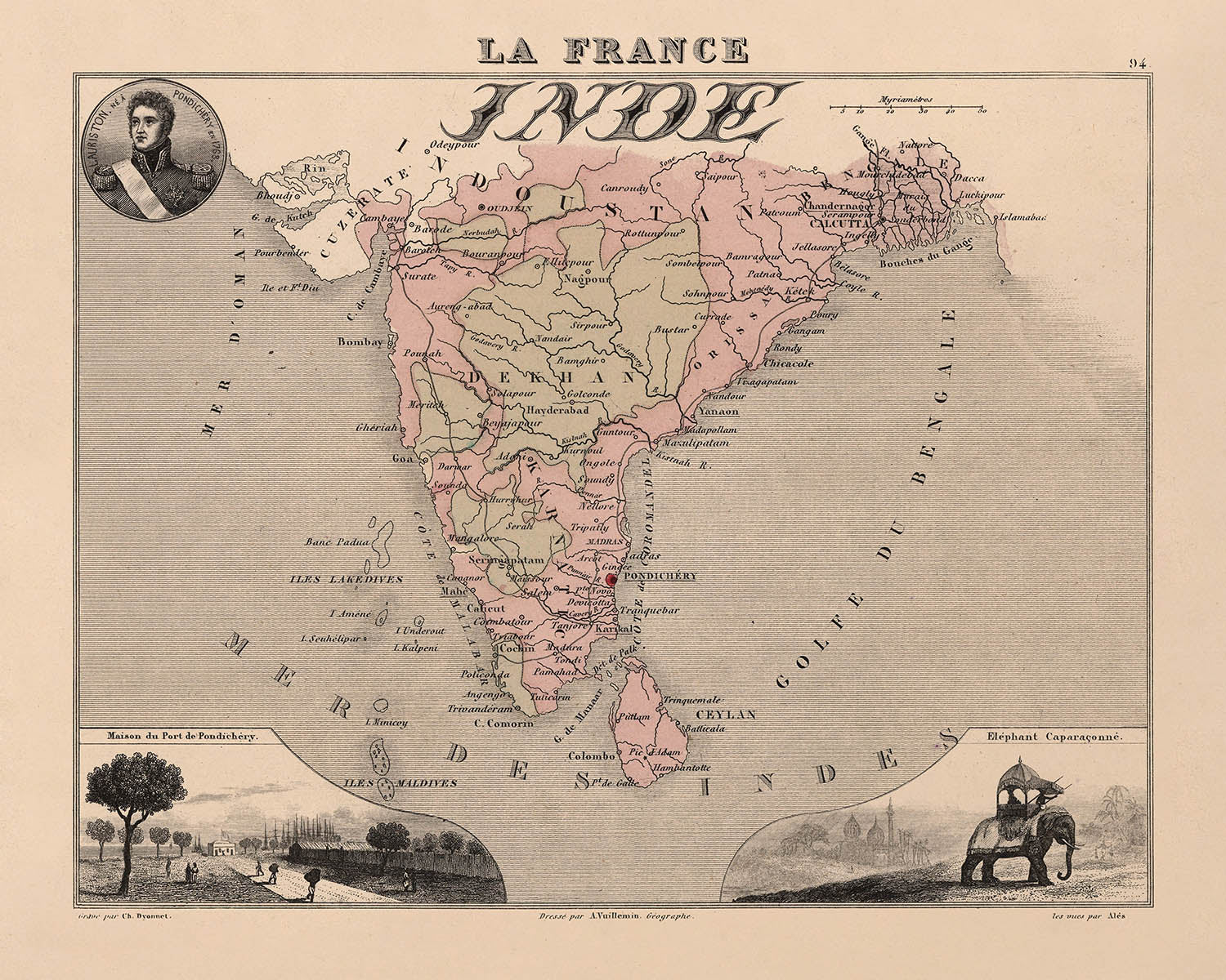
Adéntrese en el vibrante mundo de la cartografía colonial del siglo XIX con "French India", titulado originalmente Inde la France, creado por el estimado cartógrafo francés A. Vuillemin en 1869. Este mapa constituye un testimonio de las ambiciones artísticas y eruditas de su época, al combinar un preciso detalle geográfico con evocadoras viñetas que dan vida al entramado cultural y económico de los enclaves coloniales franceses en la India. El minucioso enfoque de Vuillemin se hace evidente en cada elemento, desde la clara delimitación de los territorios franceses hasta las vibrantes ilustraciones que enmarcan el mapa, ofreciendo al espectador una ventana a los paisajes y ritmos cotidianos de un lejano mundo colonial.
A. Vuillemin fue célebre por su capacidad para fusionar la cartografía científica con un gran refinamiento artístico, y este mapa es un ejemplo arquetípico de su arte. Cada región—Pondichéry, Karikal, Mahé, Yanaon y Chandernagor—está cuidadosamente representada, con límites definidos con precisión para destacar la presencia francesa en medio del vasto subcontinente indio bajo control británico. La obra de Vuillemin se distingue además por la inclusión de escenas locales, personajes notables y escudos de armas, todo ello ilustrado con esmero para evocar la identidad singular de cada enclave. Su atención al detalle no solo realza el atractivo estético del mapa, sino que también sirve como un valioso registro histórico de una época ya pasada.
La calidad artística del mapa se ve complementada por su rico contenido temático. En torno a los paneles cartográficos principales aparecen viñetas que representan a las personas, los cultivos y las actividades que caracterizaban la India francesa en el siglo XIX. Estas ilustraciones son más que mera decoración: son ventanas a la vida social y económica de la región, desde bulliciosos mercados hasta apacibles riberas. El mapa también presenta texto informativo, con estadísticas y contexto geográfico, incluida la distancia y la dirección desde París, situando así estas lejanas colonias dentro del relato más amplio de la ambición imperial francesa.
Desde el punto de vista geográfico, el mapa es una obra maestra de precisión y claridad. Grandes masas de agua como la Bahía de Bengala, el mar Arábigo y el océano Índico están representadas con esmero, mientras que ríos como el Hugli, cerca de Chandernagor, aportan profundidad y realismo a la composición. Los contornos costeros y los cursos fluviales no solo son exactos, sino que además se integran con elegancia en el diseño general del mapa. Las fronteras de los territorios franceses están claramente marcadas, ofreciendo un contraste impactante con las regiones circundantes y subrayando las complejidades geopolíticas de la India colonial.
Quizá lo más cautivador sean las ciudades y localidades que estructuran este mapa—Puducherry (Pondichéry), Karaikal, Chandannagar, Yanam y Mahé. Cada asentamiento está señalado con precisión histórica, reflejando su importancia como centro de administración, comercio e intercambio cultural. Estos enclaves, aunque pequeños en tamaño, desempeñaron un papel desproporcionadamente importante en la historia de la India francesa, sirviendo de puertas de entrada al comercio y a la interacción intercultural. Gracias a la mano experta de Vuillemin, estos lugares cobran vida e invitan al espectador a explorar no solo la geografía, sino también la historia viviente de un capítulo singular del encuentro colonial entre Francia y la India.
Ciudades y localidades en este mapa
- Puducherry (Pondichéry)
- Karaikal (Karikal)
- Chandannagar (Chandernagor)
- Yanam (Yanaon)
- Mahé
Características destacadas & Monumentos
- Mapa que muestra los enclaves franceses individuales en la India, incluidos Pondichéry, Karikal, Mahé, Yanaon y Chandernagor
- Vinetas artísticas que representan escenas locales, prácticas culturales y actividades humanas relevantes para los territorios franceses de la India
- Representaciones de la población local con atuendos tradicionales, dedicada a actividades cotidianas
- Bahía de Bengala
- Mar Arábigo
- Océano Índico
- Ríos claramente representados cerca de los enclaves, como el río Hooghly cerca de Chandernagor
- Fronteras claramente delimitadas de los territorios franceses, distinguiéndolos de las zonas circundantes bajo control británico
- Contornos costeros y cursos fluviales prominentes
Contexto histórico y de diseño
- Creado por A. Vuillemin, un renombrado cartógrafo francés del siglo XIX conocido por combinar la cartografía científica con un estilo artístico refinado
- Publicado en 1869, reflejando la extensión y la naturaleza de la influencia colonial francesa en la India durante finales del siglo XIX
- Parte de una colección caracterizada por coloridos mapas artísticos acompañados de viñetas que ilustran escenas locales, figuras notables, animales, actividades humanas, cultivos y escudos de armas
- Cada mapa de la colección va acompañado de información textual exhaustiva, incluidas estadísticas y detalles geográficos como distancias y direcciones desde París
- Estilo artístico y decorativo típico de la cartografía europea del siglo XIX, que combina precisión geográfica con contexto cultural e histórico
- Ofrece una visión del colonialismo europeo, el comercio y las interacciones culturales entre Francia y la India en aquella época
Por favor, compruebe detenidamente las imágenes para asegurarse de que se muestra un pueblo o lugar específico en este mapa. También puede ponerse en contacto con nosotros y pedirnos que revisemos el mapa por usted.
Este mapa luce magnífico en cualquier tamaño, pero siempre recomiendo optar por un tamaño mayor si dispone de espacio. Así podrá apreciar fácilmente todos los detalles.
Este mapa luce impresionante en tamaños de hasta 50in (125cm). Si busca un mapa de mayor tamaño, por favor póngase en contacto con nosotros.
El modelo en las imágenes del anuncio sostiene la versión de 16x20in (40x50cm) de este mapa.
La quinta imagen del anuncio muestra un ejemplo de mi servicio de personalización de mapas.
Si busca algo ligeramente diferente, consulte mi colección de los mejores mapas antiguos para ver si algo más le llama la atención.
Por favor, contácteme para comprobar si una determinada ubicación, monumento o elemento aparece en este mapa.
Sería un regalo maravilloso de cumpleaños, Navidad, Día del Padre, despedida de trabajo, aniversario o inauguración de vivienda para alguien de las zonas que abarca este mapa.
Este mapa está disponible como impresión giclée sobre papel mate de archivo libre de ácido, o puede adquirirlo enmarcado. El marco es un bonito y sencillo marco negro que combina con la mayoría de las estéticas. Por favor, póngase en contacto con nosotros si desea un color o material de marco diferente. Nuestros marcos llevan un acristalamiento de acrílico de grado museístico de gran claridad (perspex/acrylite), que es significativamente menos reflectante que el vidrio, más seguro y llegará siempre en perfectas condiciones.
This map is also available as a float framed canvas, sometimes known as a shadow gap framed canvas or canvas floater. The map is printed on artist's cotton canvas and then stretched over a handmade box frame. We then "float" the canvas inside a wooden frame, which is available in a range of colours (black, dark brown, oak, antique gold and white). This is a wonderful way to present a map without glazing in front. See some examples of float framed canvas maps and explore the differences between my different finishes.
For something truly unique, this map is also available in "Unique 3D", our trademarked process that dramatically transforms the map so that it has a wonderful sense of depth. We combine the original map with detailed topography and elevation data, so that mountains and the terrain really "pop". For more info and examples of 3D maps, check my Unique 3D page.
Many of our maps and art prints are chosen as thoughtful gifts for homes, offices, studies and meaningful places.
Choose a framed option for the easiest ready-to-hang gift, or choose an unframed print if the recipient may prefer to select their own frame.
We make orders locally in 23 countries around the world, so gifts can often be produced close to the recipient. This helps them arrive faster, travel more safely, and avoid customs or import duty surprises.
- We can deliver directly to the recipient
- Framed pieces arrive ready to hang
- Unframed prints are carefully packed in a strong protective tube
- Almost every order is made locally, for faster, safer gifting
- 90-day returns give the recipient time to decide
If you are not sure what to choose, please contact us. We can help you pick the right map, size, finish or delivery option.
Para la mayoría de los pedidos, el tiempo de entrega es de aproximadamente 3 días laborables. Los productos personalizados y a medida tardan más, ya que tengo que hacer la personalización y enviártelo para su aprobación, lo cual suele tardar 1 o 2 días.
Tenga en cuenta que los pedidos enmarcados muy grandes suelen tardar más en fabricarse y entregarse.
Si necesitas que tu pedido llegue para una fecha determinada, por favor contáctame antes de hacer el pedido para que podamos encontrar la mejor manera de asegurarnos de que recibas tu pedido a tiempo.
Imprimo y enmarco mapas y obras de arte en 23 países alrededor del mundo. Esto significa que tu pedido se fabricará localmente, lo que reduce el tiempo de entrega y asegura que no se dañe durante el envío. Nunca pagarás aranceles de aduana o impuestos de importación, y pondremos menos CO2 en el aire.
Todos mis mapas y impresiones artísticas están bien empaquetados y enviados en un tubo resistente si no están enmarcados, o rodeados de espuma si están enmarcados.
Intento enviar todos los pedidos dentro de 1 o 2 días después de recibir tu pedido, aunque algunos productos (como mascarillas, tazas y bolsas de tela) pueden tardar más en fabricarse.
Si seleccionas Entrega Exprés al finalizar la compra, priorizaremos tu pedido y lo enviaremos por mensajería de 1 día (Fedex, DHL, UPS, Parcelforce).
La entrega al día siguiente también está disponible en algunos países (EE. UU., Reino Unido, Singapur, EAU), pero por favor intenta hacer tu pedido temprano en el día para que podamos enviarlo a tiempo.
Mi marco estándar es un marco de madera de fresno negro estilo galería. Es simple y tiene un aspecto bastante moderno. Mi marco estándar tiene alrededor de 20 mm (0.8 in) de ancho.
Utilizo acrílico super claro (perspex/acrylite) para el vidrio del marco. Es más ligero y seguro que el vidrio, y se ve mejor, ya que la reflectividad es menor.
Seis colores de marco estándar están disponibles de forma gratuita (negro, marrón oscuro, gris oscuro, roble, blanco y oro antiguo).El enmarcado y montaje/matizado personalizado está disponible si buscas algo diferente.
La mayoría de los mapas, arte e ilustraciones también están disponibles como un lienzo enmarcado. Utilizamos lienzo de algodón mate (no brillante), lo estiramos sobre un marco de madera de caja de origen sostenible, y luego 'flotamos' la pieza dentro de un marco de madera. El resultado final es bastante hermoso, y no hay cristal que se interponga.
Todos los marcos se proporcionan "listos para colgar", con una cuerda o soportes en la parte posterior. Los marcos muy grandes tendrán placas de colgar de alta resistencia y/o un listón de montaje. Si tienes alguna pregunta, por favor ponte en contacto.
Mira algunos ejemplos de mis mapas enmarcados y mapas en lienzo enmarcados.
Alternativamente, también puedo proporcionar mapas antiguos y obras de arte en lienzo, tablero de espuma, papel de algodón y otros materiales.
Si deseas enmarcar tu mapa o obra de arte tú mismo, por favor lee mi guía de tamaños primero.
Mis mapas son reproducciones de mapas originales de altísima calidad.
Obtengo mapas originales y raros de bibliotecas, casas de subastas y colecciones privadas de todo el mundo, los restauro en mi taller de Londres y luego uso tintas e impresoras giclée especializadas para crear hermosos mapas que lucen incluso mejor que el original.
Mis mapas están impresos en papel de archivo mate (no brillante) sin ácido que se siente de muy alta calidad y casi como una tarjeta. En términos técnicos, el peso/grosor del papel es de 10 mil/200 g/m². Es perfecto para enmarcar.
Imprimo con tintas pigmentadas Epson ultrachrome giclée UV resistentes a la decoloración, algunas de las mejores tintas que puedes encontrar.
yo también puedo hacer mapas sobre lienzo, trapo de algodón y otros materiales exóticos.
Obtenga más información sobre The Unique Maps Co..
Personalización de mapas
Si está buscando el regalo perfecto de aniversario o inauguración de la casa, puedo personalizar su mapa para hacerlo verdaderamente único. Por ejemplo, puedo agregar un mensaje corto, resaltar una ubicación importante o agregar el escudo de armas de su familia.
Las opciones son casi infinitas. Por favor mira mi página de personalización de mapas para ver algunos maravillosos ejemplos de lo que es posible.
Para pedir un mapa personalizado, seleccione "personalizar su mapa" antes de agregarlo a su carrito.
Ponerse en contacto si buscas personalizaciones y personalizaciones más complejas.
Envejecimiento del mapa
A lo largo de los años, los clientes me han preguntado cientos de veces si podían comprar un mapa que se viera uniforme. más viejo.
Bueno, ahora puedes hacerlo seleccionando Envejecido antes de agregar un mapa a tu carrito.
Todas las fotografías de productos que ve en esta página muestran el mapa en su forma original. Así es como se ve el mapa hoy.
Si selecciona Envejecido, envejeceré su mapa a mano, usando un proceso especial y único desarrollado a través de años de estudiar mapas antiguos, hablar con investigadores para comprender la química del envejecimiento del papel y, por supuesto... ¡mucha práctica!
Si no estás seguro, quédate con el color original del mapa. Si quieres algo un poco más oscuro y más viejo buscando, opte por Envejecido.
Si no estás satisfecho con tu pedido por cualquier motivo, contáctame para un reembolso sin complicaciones. Por favor, consulta nuestra política de devoluciones y reembolsos para más información.
Estoy muy seguro de que te gustará tu mapa o impresión artística restaurada. He estado haciendo esto desde 1984. Soy un vendedor de 5 estrellas en Etsy. He vendido decenas de miles de mapas e impresiones artísticas y tengo más de 5,000 opiniones reales de 5 estrellas.
Utilizo un proceso único para restaurar mapas y obras de arte que consume mucho tiempo y mano de obra. Buscar los mapas e ilustraciones originales puede llevar meses. Utilizo tecnología de última generación y extremadamente cara para escanear y restaurarlos. Como resultado, garantizo que mis mapas e impresiones artísticas son superiores a los demás - por eso puedo ofrecer un reembolso sin complicaciones.
Casi todos mis mapas e impresiones artísticas se ven increíbles en tamaños grandes (200cm, 6.5ft+) y también puedo enmarcarlos y entregártelos a través de un servicio de mensajería especial para tamaños grandes. Contáctame para discutir tus necesidades específicas.
Or try searching for something!


