


Primer gran mapa antiguo del Gran Boston de Hales, 1819: Cambridge, Salem, Harvard, Boston Sound
20% de descuento en 2 — 33% de descuento en 3
Añade dos artículos elegibles a tu carrito para recibir 20% de descuento. Añade un tercero y será complementario (equivalente a 33% de descuento al comprar tres).
No se necesita código — la oferta se aplica automáticamente al finalizar la compra.
Válido en todos los mapas estándar y impresiones de arte fino. Puedes mezclar y combinar cualquier diseño.
Si deseas enviar artículos a múltiples direcciones, por favor contáctanos antes de realizar tu pedido.
Las comisiones personalizadas y a medida están excluidas.
Contáctanos si tienes alguna pregunta
 Diseñado en Londres Hecho en the UK
Diseñado en Londres • Hecho en the UK
Diseñado en Londres Hecho en the UK
Diseñado en Londres • Hecho en the UK

Restaurado a partir del mapa original de 1819 e impreso en calidad museo. Leer la historia detrás de este mapa
Choose your size
Choose your finish


(Más información)
Mensaje de regalo y acabado personalizado

Si deseas agregar un mensaje de regalo, o un acabado (rompecabezas, tablero de aluminio, etc.) que no esté disponible aquí, por favor solicítalo en la "nota del pedido" cuando realices la compra.
Cada pedido es hecho a medida, así que si necesitas que el tamaño se ajuste ligeramente, o que se imprima en un material inusual, háznoslo saber. Hemos realizado miles de pedidos personalizados a lo largo de los años, así que hay (casi) nada que no podamos gestionar.
También puedes contactarnos antes de hacer tu pedido, ¡si lo prefieres!

- Hecho localmente. Entrega segura
- Sin aranceles ni cargos ocultos
- ¿Necesitas ayuda? Llámanos o mensaje por WhatsApp
Own a piece of history
8,000+ five-star reviews


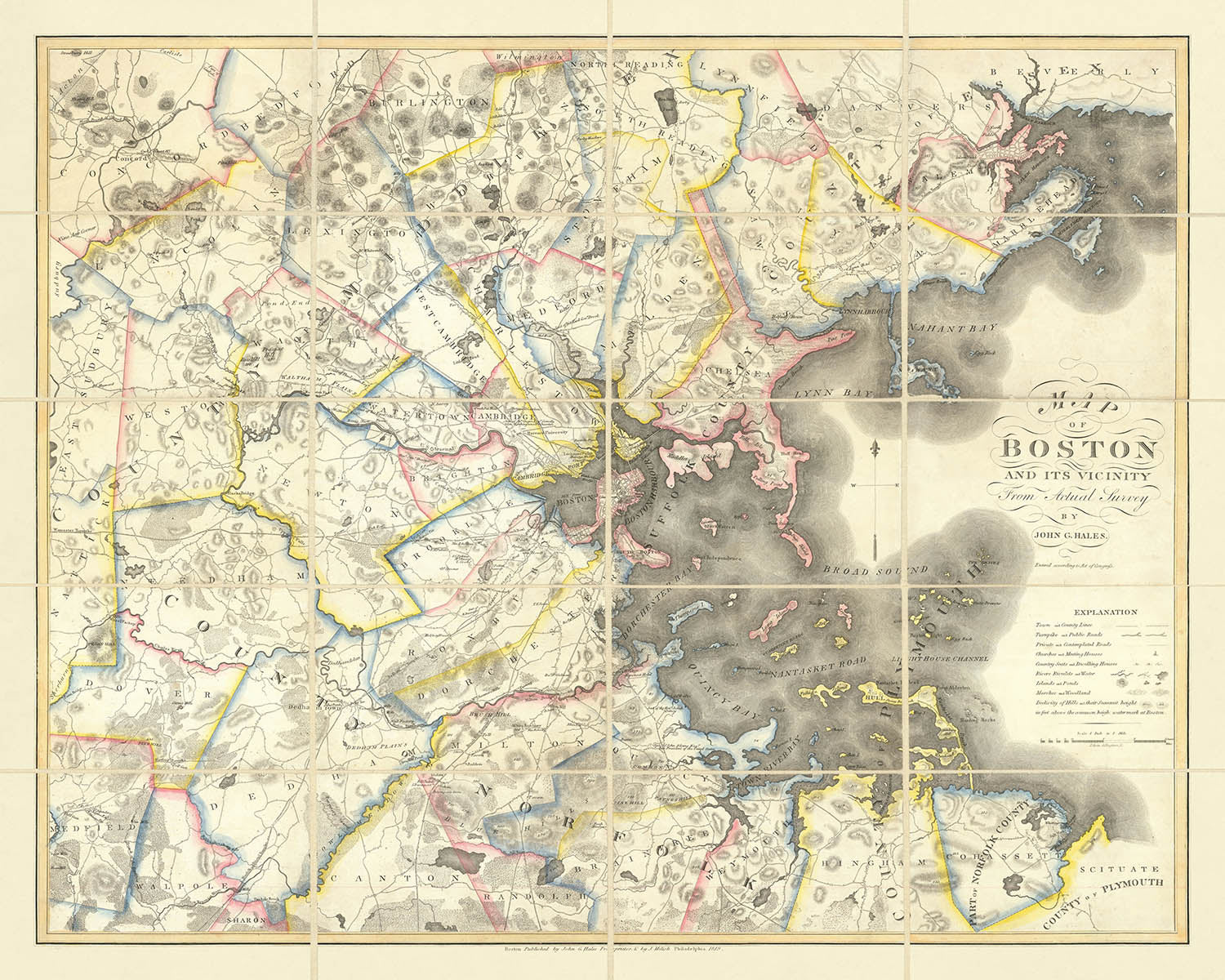
Adéntrese en el inicio del siglo XIX con el "Map of Boston and its Vicinity From Actual Survey by John G. Hales",...
Seguir leyendoAdéntrese en el inicio del siglo XIX con el "Map of Boston and its Vicinity From Actual Survey by John G. Hales", una obra maestra cartográfica publicada por primera vez en 1819. Este mapa es celebrado como el primer mapa estadounidense a gran escala del área metropolitana de Boston, y su título original es testimonio de su ambición y alcance. John Groves Hales, un pionero agrimensor inglés, elaboró este mapa en una época en la que la ciudad y su campiña circundante estaban al borde de una transformación dramática. Su minucioso trabajo ofrece una ventana inigualable al paisaje de Boston, captando las animadas calles de la ciudad, la intrincada red de caminos que se extiende hacia el exterior y la pintoresca amplitud de Boston Sound, todo ello representado con una precisión y un sentido artístico rara vez vistos en los mapas estadounidenses de la época.
John G. Hales fue un pionero en el campo de la cartografía estadounidense, al introducir en la tradición de la agrimensura de Nueva Inglaterra la avanzada técnica europea de la triangulación. Antes de Hales, la mayoría de los mapas de la región se dibujaban mediante el método de "metes and bounds", célebre por sus inexactitudes. El compromiso de Hales con el rigor científico estableció un nuevo estándar, y su mapa es reconocido como un hito en la agrimensura estadounidense. La publicación del mapa tanto en Boston como en Filadelfia habla de su amplio atractivo y de la importancia otorgada a esta detallada representación de la región.
El diseño del mapa de Hales es una armoniosa combinación de geografía política y física, en la que cada elemento se representa con una claridad extraordinaria. Los límites de los distritos están trazados con nitidez, mientras que la red de autopistas de peaje, caminos rurales y senderos del campo serpentea entre bosques, colinas y marismas, todo ello cuidadosamente sombreado y simbolizado. La esquina inferior derecha presenta una leyenda completa, que guía al observador por un paisaje lleno de detalles: desde las imponentes iglesias y los bulliciosos hoteles hasta las humildes casas de labranza salpicando la campiña. Cabe destacar que la representación pictórica de los edificios del campus de la Universidad de Harvard y del U.S. Arsenal en Watertown ofrece raras vistas del patrimonio arquitectónico de la época.
Más allá del núcleo urbano de Boston, el mapa de Hales amplía su alcance a las localidades y aldeas circundantes que un día formarían la columna vertebral del área metropolitana de Boston. Nombres como Cambridge, Salem, Quincy y Lynn aparecen junto a comunidades más pequeñas como Medford, Dedham y Brookline, cada una minuciosamente trazada según el riguroso levantamiento de Hales. El mapa también recoge las características naturales de la región—bosques, colinas y promontorios costeros como Salem Head—invitando al observador a imaginar los paisajes que recibían por igual a viajeros y residentes de principios del siglo XIX. La cuidada atención al detalle topográfico proporciona una viva sensación de lugar, anclando el mapa en las realidades físicas de su tiempo.
No se puede exagerar la importancia histórica de este mapa. Marca la primera vez que el área metropolitana de Boston se cartografió con tal precisión y detalle desde la carta de Des Barres del siglo anterior. El logro de Hales es aún más notable dadas los recursos limitados y el estado incipiente de la cartografía estadounidense. Su obra no solo proporcionó una herramienta indispensable para urbanistas, propietarios y viajeros, sino que también dejó un legado perdurable para historiadores y coleccionistas. Poseer este mapa es poseer un valioso testimonio del pasado de Boston—un testimonio de la visión y la pericia de John G. Hales, y un registro duradero de una ciudad y una región en el umbral de la modernidad.
Ciudades y localidades en este mapa
- Boston
- Cambridge
- Salem
- Quincy
- Lynn
- Newton
- Medford
- Watertown
- Chelsea
- Dedham
- Milton
- Brookline
- Roxbury
- Charlestown
- Dorchester
- Waltham
- Arlington (anteriormente West Cambridge)
- Everett (parte de Malden en ese momento)
- Malden
- Somerville (parte de Charlestown en ese momento)
- Revere (parte de Chelsea en ese momento)
Características destacadas y puntos de referencia
- Edificios del campus de la Universidad de Harvard (mostrados pictóricamente)
- Arsenal de EE. UU. en Watertown
- Red viaria detallada, incluidas las carreteras de peaje
- Límites de distrito claramente marcados
- Numerosas iglesias indicadas con símbolos
- Hoteles y posadas a lo largo de las vías principales
- Zonas boscosas y pantanos claramente delimitados
- Colinas y rasgos topográficos indicados
- Boston Sound y los elementos costeros claramente mostrados
- Salem Head visible en la esquina noreste del mapa
Contexto histórico y de diseño
- Primer mapa estadounidense a gran escala del área del Gran Boston, publicado en 1819
- Creado por John Groves Hales, un topógrafo inglés que introdujo la triangulación en la cartografía de Nueva Inglaterra
- Basado en uno de los primeros levantamientos trigonométricos realizados en América, estableciendo un nuevo estándar de precisión
- Publicado tanto en Boston como en Filadelfia, reflejando su importancia y demanda
- Presenta una armoniosa combinación de geografía política y física, con una meticulosa atención al detalle
- Incluye una leyenda completa en la esquina inferior derecha para interpretar símbolos y elementos
- Fue una herramienta indispensable para urbanistas, propietarios y viajeros, y sigue siendo un artefacto fundamental para historiadores y coleccionistas
Por favor, revise bien las imágenes para asegurarse de que se muestra una ciudad o lugar específico en este mapa. También puede ponerse en contacto con nosotros y pedirnos que lo comprobemos por usted.
Este mapa luce magnífico en cualquier tamaño, pero siempre recomiendo optar por un tamaño mayor si dispone de espacio. Así podrá apreciar fácilmente todos los detalles.
Este mapa luce increíble en tamaños de hasta 100 pulgadas (250 cm). Si busca un mapa de mayor tamaño, por favor póngase en contacto.
Tenga en cuenta: las etiquetas de este mapa son difíciles de leer si solicita un mapa de 20 pulgadas (50 cm) o menos. El mapa sigue siendo muy atractivo, pero si desea leerlo con facilidad, compre un tamaño mayor.
El modelo de las imágenes del anuncio está sosteniendo la versión de 16x20 pulgadas (40x50 cm) de este mapa.
La quinta imagen del anuncio muestra un ejemplo de mi servicio de personalización de mapas.
Si busca algo ligeramente diferente, explore mi colección de los mejores mapas antiguos para ver si algo más le llama la atención.
Por favor, contácteme para comprobar si se muestra una determinada ubicación, punto de referencia o elemento en este mapa.
Sería un maravilloso regalo de cumpleaños, Navidad, Día del Padre, despedida laboral, aniversario o inauguración de casa para alguien de las zonas cubiertas por este mapa.
Este mapa está disponible como impresión giclée sobre papel mate de archivo libre de ácido, o puede adquirirlo enmarcado. El marco es un bonito y sencillo marco negro que se adapta a la mayoría de las estéticas. Por favor, póngase en contacto si desea un color o material de marco diferente. Mis marcos llevan un cristal acrílico de calidad museística, supertransparente (perspex/acrylite), que es significativamente menos reflectante que el vidrio, más seguro y llegará siempre en perfectas condiciones.
This map is also available as a float framed canvas, sometimes known as a shadow gap framed canvas or canvas floater. The map is printed on artist's cotton canvas and then stretched over a handmade box frame. We then "float" the canvas inside a wooden frame, which is available in a range of colours (black, dark brown, oak, antique gold and white). This is a wonderful way to present a map without glazing in front. See some examples of float framed canvas maps and explore the differences between my different finishes.
For something truly unique, this map is also available in "Unique 3D", our trademarked process that dramatically transforms the map so that it has a wonderful sense of depth. We combine the original map with detailed topography and elevation data, so that mountains and the terrain really "pop". For more info and examples of 3D maps, check my Unique 3D page.
Adéntrese en el inicio del siglo XIX con el "Map of Boston and its Vicinity From Actual Survey by John G. Hales", una obra maestra cartográfica publicada por primera vez en 1819. Este mapa es celebrado como el primer mapa estadounidense a gran escala del área metropolitana de Boston, y su título original es testimonio de su ambición y alcance. John Groves Hales, un pionero agrimensor inglés, elaboró este mapa en una época en la que la ciudad y su campiña circundante estaban al borde de una transformación dramática. Su minucioso trabajo ofrece una ventana inigualable al paisaje de Boston, captando las animadas calles de la ciudad, la intrincada red de caminos que se extiende hacia el exterior y la pintoresca amplitud de Boston Sound, todo ello representado con una precisión y un sentido artístico rara vez vistos en los mapas estadounidenses de la época.
John G. Hales fue un pionero en el campo de la cartografía estadounidense, al introducir en la tradición de la agrimensura de Nueva Inglaterra la avanzada técnica europea de la triangulación. Antes de Hales, la mayoría de los mapas de la región se dibujaban mediante el método de "metes and bounds", célebre por sus inexactitudes. El compromiso de Hales con el rigor científico estableció un nuevo estándar, y su mapa es reconocido como un hito en la agrimensura estadounidense. La publicación del mapa tanto en Boston como en Filadelfia habla de su amplio atractivo y de la importancia otorgada a esta detallada representación de la región.
El diseño del mapa de Hales es una armoniosa combinación de geografía política y física, en la que cada elemento se representa con una claridad extraordinaria. Los límites de los distritos están trazados con nitidez, mientras que la red de autopistas de peaje, caminos rurales y senderos del campo serpentea entre bosques, colinas y marismas, todo ello cuidadosamente sombreado y simbolizado. La esquina inferior derecha presenta una leyenda completa, que guía al observador por un paisaje lleno de detalles: desde las imponentes iglesias y los bulliciosos hoteles hasta las humildes casas de labranza salpicando la campiña. Cabe destacar que la representación pictórica de los edificios del campus de la Universidad de Harvard y del U.S. Arsenal en Watertown ofrece raras vistas del patrimonio arquitectónico de la época.
Más allá del núcleo urbano de Boston, el mapa de Hales amplía su alcance a las localidades y aldeas circundantes que un día formarían la columna vertebral del área metropolitana de Boston. Nombres como Cambridge, Salem, Quincy y Lynn aparecen junto a comunidades más pequeñas como Medford, Dedham y Brookline, cada una minuciosamente trazada según el riguroso levantamiento de Hales. El mapa también recoge las características naturales de la región—bosques, colinas y promontorios costeros como Salem Head—invitando al observador a imaginar los paisajes que recibían por igual a viajeros y residentes de principios del siglo XIX. La cuidada atención al detalle topográfico proporciona una viva sensación de lugar, anclando el mapa en las realidades físicas de su tiempo.
No se puede exagerar la importancia histórica de este mapa. Marca la primera vez que el área metropolitana de Boston se cartografió con tal precisión y detalle desde la carta de Des Barres del siglo anterior. El logro de Hales es aún más notable dadas los recursos limitados y el estado incipiente de la cartografía estadounidense. Su obra no solo proporcionó una herramienta indispensable para urbanistas, propietarios y viajeros, sino que también dejó un legado perdurable para historiadores y coleccionistas. Poseer este mapa es poseer un valioso testimonio del pasado de Boston—un testimonio de la visión y la pericia de John G. Hales, y un registro duradero de una ciudad y una región en el umbral de la modernidad.
Ciudades y localidades en este mapa
- Boston
- Cambridge
- Salem
- Quincy
- Lynn
- Newton
- Medford
- Watertown
- Chelsea
- Dedham
- Milton
- Brookline
- Roxbury
- Charlestown
- Dorchester
- Waltham
- Arlington (anteriormente West Cambridge)
- Everett (parte de Malden en ese momento)
- Malden
- Somerville (parte de Charlestown en ese momento)
- Revere (parte de Chelsea en ese momento)
Características destacadas y puntos de referencia
- Edificios del campus de la Universidad de Harvard (mostrados pictóricamente)
- Arsenal de EE. UU. en Watertown
- Red viaria detallada, incluidas las carreteras de peaje
- Límites de distrito claramente marcados
- Numerosas iglesias indicadas con símbolos
- Hoteles y posadas a lo largo de las vías principales
- Zonas boscosas y pantanos claramente delimitados
- Colinas y rasgos topográficos indicados
- Boston Sound y los elementos costeros claramente mostrados
- Salem Head visible en la esquina noreste del mapa
Contexto histórico y de diseño
- Primer mapa estadounidense a gran escala del área del Gran Boston, publicado en 1819
- Creado por John Groves Hales, un topógrafo inglés que introdujo la triangulación en la cartografía de Nueva Inglaterra
- Basado en uno de los primeros levantamientos trigonométricos realizados en América, estableciendo un nuevo estándar de precisión
- Publicado tanto en Boston como en Filadelfia, reflejando su importancia y demanda
- Presenta una armoniosa combinación de geografía política y física, con una meticulosa atención al detalle
- Incluye una leyenda completa en la esquina inferior derecha para interpretar símbolos y elementos
- Fue una herramienta indispensable para urbanistas, propietarios y viajeros, y sigue siendo un artefacto fundamental para historiadores y coleccionistas
Por favor, revise bien las imágenes para asegurarse de que se muestra una ciudad o lugar específico en este mapa. También puede ponerse en contacto con nosotros y pedirnos que lo comprobemos por usted.
Este mapa luce magnífico en cualquier tamaño, pero siempre recomiendo optar por un tamaño mayor si dispone de espacio. Así podrá apreciar fácilmente todos los detalles.
Este mapa luce increíble en tamaños de hasta 100 pulgadas (250 cm). Si busca un mapa de mayor tamaño, por favor póngase en contacto.
Tenga en cuenta: las etiquetas de este mapa son difíciles de leer si solicita un mapa de 20 pulgadas (50 cm) o menos. El mapa sigue siendo muy atractivo, pero si desea leerlo con facilidad, compre un tamaño mayor.
El modelo de las imágenes del anuncio está sosteniendo la versión de 16x20 pulgadas (40x50 cm) de este mapa.
La quinta imagen del anuncio muestra un ejemplo de mi servicio de personalización de mapas.
Si busca algo ligeramente diferente, explore mi colección de los mejores mapas antiguos para ver si algo más le llama la atención.
Por favor, contácteme para comprobar si se muestra una determinada ubicación, punto de referencia o elemento en este mapa.
Sería un maravilloso regalo de cumpleaños, Navidad, Día del Padre, despedida laboral, aniversario o inauguración de casa para alguien de las zonas cubiertas por este mapa.
Este mapa está disponible como impresión giclée sobre papel mate de archivo libre de ácido, o puede adquirirlo enmarcado. El marco es un bonito y sencillo marco negro que se adapta a la mayoría de las estéticas. Por favor, póngase en contacto si desea un color o material de marco diferente. Mis marcos llevan un cristal acrílico de calidad museística, supertransparente (perspex/acrylite), que es significativamente menos reflectante que el vidrio, más seguro y llegará siempre en perfectas condiciones.
This map is also available as a float framed canvas, sometimes known as a shadow gap framed canvas or canvas floater. The map is printed on artist's cotton canvas and then stretched over a handmade box frame. We then "float" the canvas inside a wooden frame, which is available in a range of colours (black, dark brown, oak, antique gold and white). This is a wonderful way to present a map without glazing in front. See some examples of float framed canvas maps and explore the differences between my different finishes.
For something truly unique, this map is also available in "Unique 3D", our trademarked process that dramatically transforms the map so that it has a wonderful sense of depth. We combine the original map with detailed topography and elevation data, so that mountains and the terrain really "pop". For more info and examples of 3D maps, check my Unique 3D page.
Many of our maps and art prints are chosen as thoughtful gifts for homes, offices, studies and meaningful places.
Choose a framed option for the easiest ready-to-hang gift, or choose an unframed print if the recipient may prefer to select their own frame.
We make orders locally in 23 countries around the world, so gifts can often be produced close to the recipient. This helps them arrive faster, travel more safely, and avoid customs or import duty surprises.
- We can deliver directly to the recipient
- Framed pieces arrive ready to hang
- Unframed prints are carefully packed in a strong protective tube
- Almost every order is made locally, for faster, safer gifting
- 90-day returns give the recipient time to decide
If you are not sure what to choose, please contact us. We can help you pick the right map, size, finish or delivery option.
Para la mayoría de los pedidos, el tiempo de entrega es de aproximadamente 3 días laborables. Los productos personalizados y a medida tardan más, ya que tengo que hacer la personalización y enviártelo para su aprobación, lo cual suele tardar 1 o 2 días.
Tenga en cuenta que los pedidos enmarcados muy grandes suelen tardar más en fabricarse y entregarse.
Si necesitas que tu pedido llegue para una fecha determinada, por favor contáctame antes de hacer el pedido para que podamos encontrar la mejor manera de asegurarnos de que recibas tu pedido a tiempo.
Imprimo y enmarco mapas y obras de arte en 23 países alrededor del mundo. Esto significa que tu pedido se fabricará localmente, lo que reduce el tiempo de entrega y asegura que no se dañe durante el envío. Nunca pagarás aranceles de aduana o impuestos de importación, y pondremos menos CO2 en el aire.
Todos mis mapas y impresiones artísticas están bien empaquetados y enviados en un tubo resistente si no están enmarcados, o rodeados de espuma si están enmarcados.
Intento enviar todos los pedidos dentro de 1 o 2 días después de recibir tu pedido, aunque algunos productos (como mascarillas, tazas y bolsas de tela) pueden tardar más en fabricarse.
Si seleccionas Entrega Exprés al finalizar la compra, priorizaremos tu pedido y lo enviaremos por mensajería de 1 día (Fedex, DHL, UPS, Parcelforce).
La entrega al día siguiente también está disponible en algunos países (EE. UU., Reino Unido, Singapur, EAU), pero por favor intenta hacer tu pedido temprano en el día para que podamos enviarlo a tiempo.
Mi marco estándar es un marco de madera de fresno negro estilo galería. Es simple y tiene un aspecto bastante moderno. Mi marco estándar tiene alrededor de 20 mm (0.8 in) de ancho.
Utilizo acrílico super claro (perspex/acrylite) para el vidrio del marco. Es más ligero y seguro que el vidrio, y se ve mejor, ya que la reflectividad es menor.
Seis colores de marco estándar están disponibles de forma gratuita (negro, marrón oscuro, gris oscuro, roble, blanco y oro antiguo).El enmarcado y montaje/matizado personalizado está disponible si buscas algo diferente.
La mayoría de los mapas, arte e ilustraciones también están disponibles como un lienzo enmarcado. Utilizamos lienzo de algodón mate (no brillante), lo estiramos sobre un marco de madera de caja de origen sostenible, y luego 'flotamos' la pieza dentro de un marco de madera. El resultado final es bastante hermoso, y no hay cristal que se interponga.
Todos los marcos se proporcionan "listos para colgar", con una cuerda o soportes en la parte posterior. Los marcos muy grandes tendrán placas de colgar de alta resistencia y/o un listón de montaje. Si tienes alguna pregunta, por favor ponte en contacto.
Mira algunos ejemplos de mis mapas enmarcados y mapas en lienzo enmarcados.
Alternativamente, también puedo proporcionar mapas antiguos y obras de arte en lienzo, tablero de espuma, papel de algodón y otros materiales.
Si deseas enmarcar tu mapa o obra de arte tú mismo, por favor lee mi guía de tamaños primero.
Mis mapas son reproducciones de mapas originales de altísima calidad.
Obtengo mapas originales y raros de bibliotecas, casas de subastas y colecciones privadas de todo el mundo, los restauro en mi taller de Londres y luego uso tintas e impresoras giclée especializadas para crear hermosos mapas que lucen incluso mejor que el original.
Mis mapas están impresos en papel de archivo mate (no brillante) sin ácido que se siente de muy alta calidad y casi como una tarjeta. En términos técnicos, el peso/grosor del papel es de 10 mil/200 g/m². Es perfecto para enmarcar.
Imprimo con tintas pigmentadas Epson ultrachrome giclée UV resistentes a la decoloración, algunas de las mejores tintas que puedes encontrar.
yo también puedo hacer mapas sobre lienzo, trapo de algodón y otros materiales exóticos.
Obtenga más información sobre The Unique Maps Co..
Personalización de mapas
Si está buscando el regalo perfecto de aniversario o inauguración de la casa, puedo personalizar su mapa para hacerlo verdaderamente único. Por ejemplo, puedo agregar un mensaje corto, resaltar una ubicación importante o agregar el escudo de armas de su familia.
Las opciones son casi infinitas. Por favor mira mi página de personalización de mapas para ver algunos maravillosos ejemplos de lo que es posible.
Para pedir un mapa personalizado, seleccione "personalizar su mapa" antes de agregarlo a su carrito.
Ponerse en contacto si buscas personalizaciones y personalizaciones más complejas.
Envejecimiento del mapa
A lo largo de los años, los clientes me han preguntado cientos de veces si podían comprar un mapa que se viera uniforme. más viejo.
Bueno, ahora puedes hacerlo seleccionando Envejecido antes de agregar un mapa a tu carrito.
Todas las fotografías de productos que ve en esta página muestran el mapa en su forma original. Así es como se ve el mapa hoy.
Si selecciona Envejecido, envejeceré su mapa a mano, usando un proceso especial y único desarrollado a través de años de estudiar mapas antiguos, hablar con investigadores para comprender la química del envejecimiento del papel y, por supuesto... ¡mucha práctica!
Si no estás seguro, quédate con el color original del mapa. Si quieres algo un poco más oscuro y más viejo buscando, opte por Envejecido.
Si no estás satisfecho con tu pedido por cualquier motivo, contáctame para un reembolso sin complicaciones. Por favor, consulta nuestra política de devoluciones y reembolsos para más información.
Estoy muy seguro de que te gustará tu mapa o impresión artística restaurada. He estado haciendo esto desde 1984. Soy un vendedor de 5 estrellas en Etsy. He vendido decenas de miles de mapas e impresiones artísticas y tengo más de 5,000 opiniones reales de 5 estrellas.
Utilizo un proceso único para restaurar mapas y obras de arte que consume mucho tiempo y mano de obra. Buscar los mapas e ilustraciones originales puede llevar meses. Utilizo tecnología de última generación y extremadamente cara para escanear y restaurarlos. Como resultado, garantizo que mis mapas e impresiones artísticas son superiores a los demás - por eso puedo ofrecer un reembolso sin complicaciones.
Casi todos mis mapas e impresiones artísticas se ven increíbles en tamaños grandes (200cm, 6.5ft+) y también puedo enmarcarlos y entregártelos a través de un servicio de mensajería especial para tamaños grandes. Contáctame para discutir tus necesidades específicas.
Or try searching for something!


