

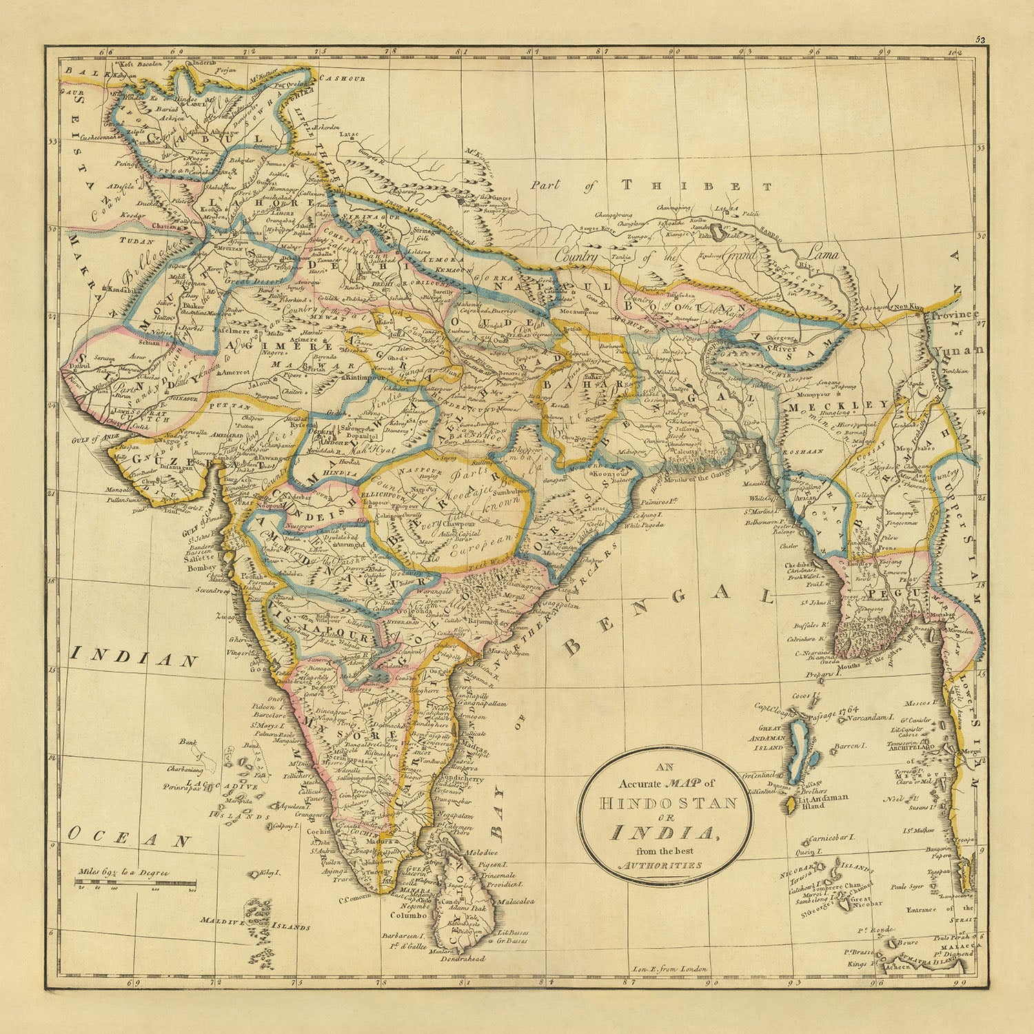

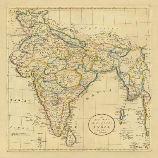


Antigua mapa de India, Pakistán y Bangladés por Carey, 1814: Hindoostán, Ceilán, Birmania, Islas Andamán, Bahía de Bengala
Christmas Express Delivery
You can order up until 10am on December 22 with Express Delivery to receive your order by Christmas.
Unframed products are much more likely to arrive by Christmas. Framed products may arrive on time, but they move more slowly, particularly when couriers are so overloaded with packages.
Personalised orders are unlikely to arrive on time (but if you absolutely must have a personalised product, please contact me and I'll do my best to help!)
Contact me for info on last-minute deliveries.
Spend £250, Save £50 Christmas Express Delivery available
Christmas Express Delivery
You can order up until 10am on December 22 with Express Delivery to receive your order by Christmas.
Unframed products are much more likely to arrive by Christmas. Framed products may arrive on time, but they move more slowly, particularly when couriers are so overloaded with packages.
Personalised orders are unlikely to arrive on time (but if you absolutely must have a personalised product, please contact me and I'll do my best to help!)
Contact me for info on last-minute deliveries.
Spend £250, Save £50

-
![]() Handmade in the UK (we're based in London)
Handmade in the UK (we're based in London)
-
FREE delivery in 3-4 days ⓘ
Free delivery in 3-4 days
Your map should be delivered in 3-4 working days with free delivery, worldwide.
Please use Express Delivery at checkout for Christmas orders. Framed orders may arrive with Express Delivery, but it is not guaranteed.
New for 2025: After you order, you can send a beautiful gift preview by email, if you're worried it won't arrive on time.
We make maps by hand locally in 23 countries. If you're buying a gift for someone in another country, we will make the map locally to them.
You will never pay import tax or customs duty.
Check the Christmas delivery guide for order deadlines. Delivery times are starting to slow down, and will continue to slow down towards Christmas.
Express delivery is available at checkout which can reduce the delivery time to 1-2 days.
Please note that personalised maps, and larger framed maps, can take longer to produce and deliver.
If you need your order to arrive by a certain date, contact me and we can discuss your options.
-
FREE gift preview
ⓘ
Digital gift preview
New for 2025: After you complete your order, you can send a beautiful digital preview to the gift recipient. Just provide their email address and we'll do the rest. (Their email address will not be stored or used for any other purpose.)
This is perfect for Christmas gifting, particularly if you're concerned that your order might not arrive in time for Christmas.
-
90 day money back guarantee
ⓘ
90 días para devolver y reembolsar
Los productos se pueden devolver dentro de los 90 días para un reembolso completo, o cambio por otro producto.
Para artículos personalizados y hechos a medida, podemos ofrecerte crédito en la tienda o una tarjeta de regalo sin fecha de caducidad, ya que no podemos revender pedidos personalizados.
Si tienes alguna pregunta, ponte en contacto. Para más información, consulta nuestra política de devoluciones y cambios.

My maps are rare, museum-grade, restored old maps sourced from libraries, auction houses and private collections across the globe.
Framing & free personalisation available
1. Select your size
2. Frame & personalise your map
There is limited framing & personalisation capacity available. Order by 10am tomorrow for Christmas delivery.


Mensaje de regalo y acabado personalizado

Si deseas agregar un mensaje de regalo, o un acabado (rompecabezas, tablero de aluminio, etc.) que no esté disponible aquí, por favor solicítalo en la "nota del pedido" cuando realices la compra.
Cada pedido es hecho a medida, así que si necesitas que el tamaño se ajuste ligeramente, o que se imprima en un material inusual, háznoslo saber. Hemos realizado miles de pedidos personalizados a lo largo de los años, así que hay (casi) nada que no podamos gestionar.
También puedes contactarnos antes de hacer tu pedido, ¡si lo prefieres!

- Handmade locally. No import duty or tax
- FREE Delivery by Christmas
- Love it or your money back (90 days)
- Questions? WhatsApp me any time
Own a piece of history
5,000+ 5 star reviews


"Un Mapa Preciso de Hindostán e India, de las mejores Autoridades" es una pieza extraordinaria de la historia cartográfica, meticulosamente elaborada por Mathew Carey en 1814. Carey, un renombrado editor con sede en Filadelfia, fue una de las figuras pioneras en la cartografía estadounidense, y este mapa es un testimonio de su excepcional habilidad y dedicación. El enfoque del mapa está en los países de India, Pakistán y Bangladés, pero se extiende para incluir la costa oeste de la Península Malaya, al norte hasta el Tíbet y Kabul. Este amplio alcance geográfico, combinado con las representaciones políticas y físicas detalladas del mapa, lo convierten en una fascinante representación de la región durante principios del siglo XIX.
El tema principal del mapa es India, pero también proporciona una representación detallada de las regiones circundantes, incluyendo Hindostán, Ceilán, Birmania, las Islas Andamán y la Bahía de Bengala. Estas áreas están representadas con notable precisión, reflejando el compromiso de Carey con la exactitud y el detalle. El estilo del mapa es tanto político como físico, ofreciendo una visión integral de las fronteras políticas y los paisajes físicos de la región. El resultado es una representación ricamente estratificada que proporciona una gran cantidad de información sobre la geografía y el paisaje político de la región.
El mapa de Carey es particularmente notable por su representación de India, que fue uno de los primeros de su tipo en ser impreso en América. El mapa proporciona una vista detallada de las ciudades, pueblos y regiones del país, así como de sus fenómenos naturales y puntos de referencia. También ofrece un vistazo al contexto histórico de la época, brindando una perspectiva única sobre los cambios políticos y geográficos de la región durante principios del siglo XIX.
En conclusión, "Un Mapa Preciso de Hindostán e India, de las mejores Autoridades" es una pieza notable de la historia cartográfica. Su representación detallada de India y las regiones circundantes, combinada con su importancia histórica como uno de los primeros mapas de India impresos en América, lo convierten en una valiosa adición a cualquier colección. La cuidadosa atención del mapa al detalle, desde su representación precisa de ciudades y pueblos hasta su intrincada representación de fenómenos naturales y puntos de referencia, refleja el compromiso de Carey con la exactitud y su habilidad como cartógrafo. Este mapa no es solo una representación geográfica, sino una ventana al pasado, ofreciendo una perspectiva única sobre una región fascinante durante un momento crucial en la historia.
Dado el enfoque del mapa en India, Pakistán y Bangladés, así como en las regiones circundantes, se cubren los siguientes puntos de interés:
India:
- Ciudades importantes como Delhi, Mumbai y Kolkata
- Puntos de referencia históricos como el Taj Mahal en Agra
- El río Ganges, una característica natural significativa
- El desierto de Thar, otra característica natural notable
Pakistán:
- Ciudades importantes como Karachi, Lahore e Islamabad
- El río Indo, una característica natural significativa
- El paso de Khyber, una ruta comercial histórica
Bangladés:
- Ciudades importantes como Dhaka y Chittagong
- Los Sundarbans, el mayor bosque de manglares del mundo
- El delta del Ganges-Brahmaputra, una característica natural significativa
Hindostán:
- Ciudades importantes como Varanasi y Jaipur
- La cordillera del Himalaya, una característica natural significativa
- Puntos de referencia históricos como el Fuerte Rojo en Delhi
Ceilán (Sri Lanka moderna):
- Ciudades importantes como Colombo y Kandy
- Las Tierras Altas Centrales, una característica natural significativa
- Monumentos históricos como el Templo del Diente en Kandy
Birmania (Myanmar Actual):
- Ciudades importantes como Yangón y Mandalay
- El río Irrawaddy, una característica natural significativa
- Monumentos históricos como la Pagoda Shwedagon en Yangón
Islas Andamán:
- Las tribus Great Andamanese, habitantes indígenas de las islas
- La biodiversidad única de las islas
Bahía de Bengala:
- El papel significativo que juega en el clima de la región
- El delta de Sundarbans, el delta más grande del mundo formado por los ríos Ganges, Brahmaputra y Meghna.
Por favor, verifica las imágenes para asegurarte de que una ciudad o lugar específico esté mostrado en este mapa. También puedes ponerte en contacto y pedirnos que revisemos el mapa por ti.
Este mapa se ve genial en todos los tamaños, pero siempre recomiendo optar por un tamaño más grande si tienes espacio. De esa manera, puedes distinguir fácilmente todos los detalles.
Este mapa se ve increíble en tamaños de hasta 70in (180cm). Si estás buscando un mapa más grande, por favor ponte en contacto.
El modelo en las imágenes del listado sostiene la versión de 18x18in (45x55cm) de este mapa.
La quinta imagen del listado muestra un ejemplo de mi servicio de personalización de mapas.
Si estás buscando algo ligeramente diferente, echa un vistazo a mi colección de los mejores mapas antiguos para ver si algo más llama tu atención.
Por favor contáctame para verificar si una ubicación, monumento o característica específica está mostrada en este mapa.
Esto sería un maravilloso regalo de cumpleaños, Navidad, Día del Padre, despedida de trabajo, aniversario o inauguración de casa para alguien de las áreas cubiertas por este mapa.
Este mapa está disponible como una impresión giclée en papel mate libre de ácido y de archivo, o puedes comprarlo enmarcado. El marco es un bonito y simple marco negro que se adapta a la mayoría de las estéticas. Por favor, ponte en contacto si deseas un color o material de marco diferente. Mis marcos están envidriados con acrílico de grado museo superclaro (perspex/acrylite), que es significativamente menos reflectante que el vidrio, más seguro, y siempre llegará en perfectas condiciones.
This map is also available as a float framed canvas, sometimes known as a shadow gap framed canvas or canvas floater. The map is printed on artist's cotton canvas and then stretched over a handmade box frame. We then "float" the canvas inside a wooden frame, which is available in a range of colours (black, dark brown, oak, antique gold and white). This is a wonderful way to present a map without glazing in front. See some examples of float framed canvas maps and explore the differences between my different finishes.
For something truly unique, this map is also available in "Unique 3D", our trademarked process that dramatically transforms the map so that it has a wonderful sense of depth. We combine the original map with detailed topography and elevation data, so that mountains and the terrain really "pop". For more info and examples of 3D maps, check my Unique 3D page.
Para la mayoría de los pedidos, el tiempo de entrega es de aproximadamente 3 días laborables. Los productos personalizados y a medida tardan más, ya que tengo que hacer la personalización y enviártelo para su aprobación, lo cual suele tardar 1 o 2 días.
Tenga en cuenta que los pedidos enmarcados muy grandes suelen tardar más en fabricarse y entregarse.
Si necesitas que tu pedido llegue para una fecha determinada, por favor contáctame antes de hacer el pedido para que podamos encontrar la mejor manera de asegurarnos de que recibas tu pedido a tiempo.
Imprimo y enmarco mapas y obras de arte en 23 países alrededor del mundo. Esto significa que tu pedido se fabricará localmente, lo que reduce el tiempo de entrega y asegura que no se dañe durante el envío. Nunca pagarás aranceles de aduana o impuestos de importación, y pondremos menos CO2 en el aire.
Todos mis mapas y impresiones artísticas están bien empaquetados y enviados en un tubo resistente si no están enmarcados, o rodeados de espuma si están enmarcados.
Intento enviar todos los pedidos dentro de 1 o 2 días después de recibir tu pedido, aunque algunos productos (como mascarillas, tazas y bolsas de tela) pueden tardar más en fabricarse.
Si seleccionas Entrega Exprés al finalizar la compra, priorizaremos tu pedido y lo enviaremos por mensajería de 1 día (Fedex, DHL, UPS, Parcelforce).
La entrega al día siguiente también está disponible en algunos países (EE. UU., Reino Unido, Singapur, EAU), pero por favor intenta hacer tu pedido temprano en el día para que podamos enviarlo a tiempo.
Mi marco estándar es un marco de madera de fresno negro estilo galería. Es simple y tiene un aspecto bastante moderno. Mi marco estándar tiene alrededor de 20 mm (0.8 in) de ancho.
Utilizo acrílico super claro (perspex/acrylite) para el vidrio del marco. Es más ligero y seguro que el vidrio, y se ve mejor, ya que la reflectividad es menor.
Seis colores de marco estándar están disponibles de forma gratuita (negro, marrón oscuro, gris oscuro, roble, blanco y oro antiguo).El enmarcado y montaje/matizado personalizado está disponible si buscas algo diferente.
La mayoría de los mapas, arte e ilustraciones también están disponibles como un lienzo enmarcado. Utilizamos lienzo de algodón mate (no brillante), lo estiramos sobre un marco de madera de caja de origen sostenible, y luego 'flotamos' la pieza dentro de un marco de madera. El resultado final es bastante hermoso, y no hay cristal que se interponga.
Todos los marcos se proporcionan "listos para colgar", con una cuerda o soportes en la parte posterior. Los marcos muy grandes tendrán placas de colgar de alta resistencia y/o un listón de montaje. Si tienes alguna pregunta, por favor ponte en contacto.
Mira algunos ejemplos de mis mapas enmarcados y mapas en lienzo enmarcados.
Alternativamente, también puedo proporcionar mapas antiguos y obras de arte en lienzo, tablero de espuma, papel de algodón y otros materiales.
Si deseas enmarcar tu mapa o obra de arte tú mismo, por favor lee mi guía de tamaños primero.
Algunos de mis mapas antiguos ahora están disponibles como lienzos enmarcados. Por favor contáctame si deseas pedir un tamaño que no está disponible en mi tienda.
Los mapas antiguos en lienzo son una alternativa interesante a los mapas enmarcados convencionalmente. Dependiendo de tu gusto personal y la decoración de la habitación, los mapas en lienzo pueden "destacar" un poco más que un mapa enmarcado.
Mis mapas son reproducciones de mapas originales de altísima calidad.
Obtengo mapas originales y raros de bibliotecas, casas de subastas y colecciones privadas de todo el mundo, los restauro en mi taller de Londres y luego uso tintas e impresoras giclée especializadas para crear hermosos mapas que lucen incluso mejor que el original.
Mis mapas están impresos en papel de archivo mate (no brillante) sin ácido que se siente de muy alta calidad y casi como una tarjeta. En términos técnicos, el peso/grosor del papel es de 10 mil/200 g/m². Es perfecto para enmarcar.
Imprimo con tintas pigmentadas Epson ultrachrome giclée UV resistentes a la decoloración, algunas de las mejores tintas que puedes encontrar.
yo también puedo hacer mapas sobre lienzo, trapo de algodón y otros materiales exóticos.
Obtenga más información sobre The Unique Maps Co..
Personalización de mapas
Si está buscando el regalo perfecto de aniversario o inauguración de la casa, puedo personalizar su mapa para hacerlo verdaderamente único. Por ejemplo, puedo agregar un mensaje corto, resaltar una ubicación importante o agregar el escudo de armas de su familia.
Las opciones son casi infinitas. Por favor mira mi página de personalización de mapas para ver algunos maravillosos ejemplos de lo que es posible.
Para pedir un mapa personalizado, seleccione "personalizar su mapa" antes de agregarlo a su carrito.
Ponerse en contacto si buscas personalizaciones y personalizaciones más complejas.
Envejecimiento del mapa
A lo largo de los años, los clientes me han preguntado cientos de veces si podían comprar un mapa que se viera uniforme. más viejo.
Bueno, ahora puedes hacerlo seleccionando Envejecido antes de agregar un mapa a tu carrito.
Todas las fotografías de productos que ve en esta página muestran el mapa en su forma original. Así es como se ve el mapa hoy.
Si selecciona Envejecido, envejeceré su mapa a mano, usando un proceso especial y único desarrollado a través de años de estudiar mapas antiguos, hablar con investigadores para comprender la química del envejecimiento del papel y, por supuesto... ¡mucha práctica!
Si no estás seguro, quédate con el color original del mapa. Si quieres algo un poco más oscuro y más viejo buscando, opte por Envejecido.
Si no estás satisfecho con tu pedido por cualquier motivo, contáctame para un reembolso sin complicaciones. Por favor, consulta nuestra política de devoluciones y reembolsos para más información.
Estoy muy seguro de que te gustará tu mapa o impresión artística restaurada. He estado haciendo esto desde 1984. Soy un vendedor de 5 estrellas en Etsy. He vendido decenas de miles de mapas e impresiones artísticas y tengo más de 5,000 opiniones reales de 5 estrellas.
Utilizo un proceso único para restaurar mapas y obras de arte que consume mucho tiempo y mano de obra. Buscar los mapas e ilustraciones originales puede llevar meses. Utilizo tecnología de última generación y extremadamente cara para escanear y restaurarlos. Como resultado, garantizo que mis mapas e impresiones artísticas son superiores a los demás - por eso puedo ofrecer un reembolso sin complicaciones.
Casi todos mis mapas e impresiones artísticas se ven increíbles en tamaños grandes (200cm, 6.5ft+) y también puedo enmarcarlos y entregártelos a través de un servicio de mensajería especial para tamaños grandes. Contáctame para discutir tus necesidades específicas.
Or try searching for something!


