


Old Colonial Map of Kenya, Uganda, Rwanda & Tanzania by Edward Stanford, 1926: Nairobi, Kampala, Lake Victoria, Kilimanjaro, Uganda Railway
Compra 2, Llévate 1 Gratis
Si añades 2 artículos a tu carrito, puedes añadir un tercer producto gratis.
Esto aplica a todos los mapas y obras de arte, incluyendo piezas personalizadas y personalizadas. Puedes pedir 3 de lo mismo, o 3 cosas diferentes.
Esto equivale a un descuento del 33%, que será el mayor descuento disponible en mi tienda este año.
¡Aprovecha la oferta y cubre tus paredes con hermosos mapas y arte!
Contáctame si tienes alguna pregunta.

-
![]() Handmade in the UK (we're based in London)
Handmade in the UK (we're based in London)
-
FREE worldwide delivery in 2-3 days ⓘ
Free delivery in 2-3 days
Your map should be delivered in 2-3 working days with free delivery, worldwide.
Deliveries over the Christmas and New Year period may be slightly delayed, as couriers and postal services catch up with a huge backlog of packages.
We make maps by hand locally in 23 countries. If you're buying a gift for someone in another country, we will make the map locally to them.
You will never pay import tax or customs duty.
Express delivery is available at checkout which can reduce the delivery time to 1-2 days.
Please note that personalised maps, and larger framed maps, can take longer to produce and deliver.
If you need your order to arrive by a certain date, contact me and we can discuss your options.
-
FREE gift preview
ⓘ
Digital gift preview
After you complete your order, you can send a beautiful digital preview to the gift recipient. Just provide their email address and we'll do the rest. (Their email address will not be stored or used for any other purpose.)
This is perfect if you're concerned that your order might not arrive in time.
You can also buy a real non-expiring gift card, and email it directly to the recipient, so they can buy their own map or artwork.
-
90 day money back guarantee
ⓘ
90 días para devolver y reembolsar
Los productos se pueden devolver dentro de los 90 días para un reembolso completo, o cambio por otro producto.
Para artículos personalizados y hechos a medida, podemos ofrecerte crédito en la tienda o una tarjeta de regalo sin fecha de caducidad, ya que no podemos revender pedidos personalizados.
Si tienes alguna pregunta, ponte en contacto. Para más información, consulta nuestra política de devoluciones y cambios.

My maps are rare, museum-grade, restored old maps sourced from libraries, auction houses and private collections across the globe.
Framing & free personalisation available
1. Select your size
Click here to order a custom size.
2. Frame & personalise your map
Make your map unique with framing, hand-drawn customisation, vintage ageing, pop art text, unique 3D styling and more.


Mensaje de regalo y acabado personalizado

Si deseas agregar un mensaje de regalo, o un acabado (rompecabezas, tablero de aluminio, etc.) que no esté disponible aquí, por favor solicítalo en la "nota del pedido" cuando realices la compra.
Cada pedido es hecho a medida, así que si necesitas que el tamaño se ajuste ligeramente, o que se imprima en un material inusual, háznoslo saber. Hemos realizado miles de pedidos personalizados a lo largo de los años, así que hay (casi) nada que no podamos gestionar.
También puedes contactarnos antes de hacer tu pedido, ¡si lo prefieres!

- Handmade locally. No import duty or tax
- FREE worldwide delivery
- Love it or your money back (90 days)
- Questions? WhatsApp me any time
Own a piece of history
5,000+ 5 star reviews


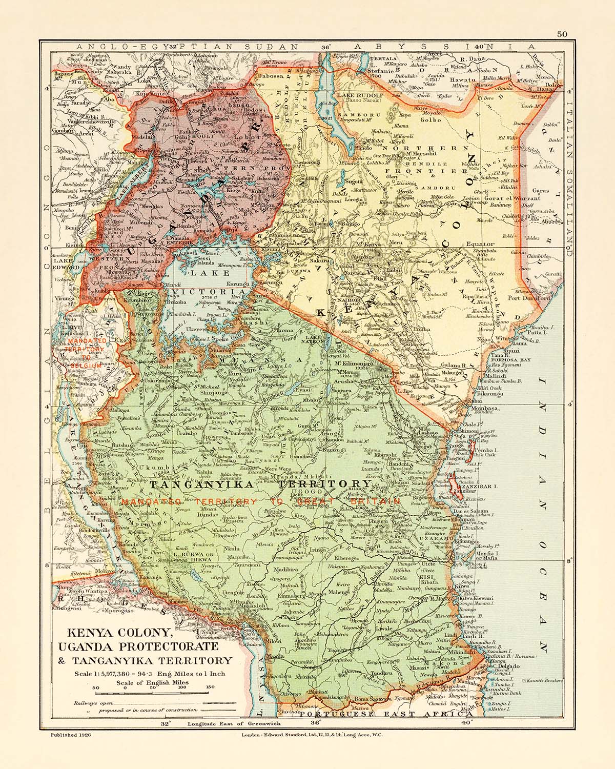
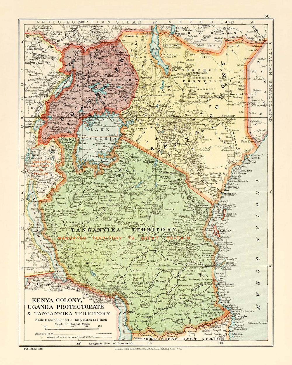
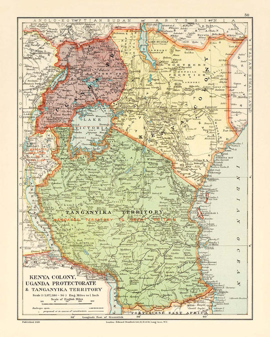
Step into the captivating world of early 20th-century cartography with "Kenya Colony, Uganda Protectorate & Tanganyika Territory," a map that stands as both a testament to colonial ambition and a masterpiece of geographical representation. Crafted in 1926 by the esteemed Edward Stanford Ltd., this map was published at a time when the British Empire was meticulously charting its East African domains. The original title itself evokes the era’s spirit of exploration and administration, offering a window into a landscape on the cusp of transformation. This map’s careful delineation of political boundaries and infrastructure reveals not only the extent of British influence but also the complexity and diversity of the regions that would become modern-day Kenya, Uganda, Rwanda, and Tanzania.
Edward Stanford Ltd., the legendary London-based mapmaker, brought to this work a legacy of precision and artistry inherited from John Arrowsmith, one of Britain’s great cartographic pioneers. Stanford’s maps were renowned for their clarity, accuracy, and elegance, serving explorers, scholars, and statesmen alike. This particular map, drawn for the prestigious London Atlas of Universal Geography, reflects the high standards of the "Whitehall" edition—an atlas prized for its comprehensive coverage and meticulous detail. The inclusion of a detailed legend, latitudinal and longitudinal lines, and a bar scale in English miles speaks to the mapmaker’s commitment to both scientific accuracy and practical usability.
The map’s physical and political detail is extraordinary, capturing the intricate tapestry of East Africa’s natural and human landscapes. Major lakes—Victoria, Albert, Edward, Kivu, and Tanganyika—are rendered with exquisite care, their sprawling shorelines and island clusters like the Sese and Ukerewe Islands inviting closer inspection. Rivers such as the Victoria Nile and the Tana snake across the map, tracing the lifeblood of the region’s civilizations. The Indian Ocean coastline, with its prominent port of Mombasa, hints at centuries of maritime trade and cultural exchange, while the inland railways—most notably the Uganda Railway—herald the dawn of modern infrastructure and connectivity.
Rising above the plains, the region’s dramatic topography is brought to life through the use of hachures, a classic cartographic technique that conveys the grandeur of mountains and valleys. The legendary Ruwenzori Mountains, often called the "Mountains of the Moon," are depicted alongside the iconic peaks of Mount Kenya, Mount Elgon, and Mount Kilimanjaro. These natural wonders, shrouded in myth and scientific intrigue, dominate the landscape and have long inspired explorers and naturalists. The map’s careful rendering of borders—between Kenya Colony, Uganda Protectorate, and Tanganyika Territory—reflects the geopolitical realities of the time, while also hinting at the future emergence of independent African nations.
Beyond its natural features, the map is a living document of the region’s vibrant urban centers and settlements. Cities such as Nairobi, Kampala, Dar es Salaam, and Kigali are marked as hubs of administration, commerce, and culture, each destined to become major metropolises in the decades ahead. Towns like Mombasa, Kisumu (then Port Florence), Jinja, and Arusha are also featured, their positions revealing the patterns of colonial development and indigenous settlement. This map is not only a work of art but a historical artifact—an invitation to explore the dynamic interplay of geography, history, and human endeavor in one of Africa’s most fascinating regions.
Cities and towns on this map
- Kenya (modern-day):
- Nairobi
- Mombasa
- Kisumu (labelled as Port Florence)
- Nakuru
- Eldoret (labelled as Eldoret or Uasin Gishu)
- Nyeri
- Machakos
-
Thika
-
Uganda (modern-day):
- Kampala
- Jinja
- Entebbe
- Masaka
- Gulu
- Mbale
- Fort Portal (labelled as Fort Portal)
-
Masindi
-
Tanzania (Tanganyika Territory, modern-day):
- Dar es Salaam
- Mwanza
- Tabora
- Kigoma
- Dodoma
- Arusha
- Moshi
- Tanga
-
Bukoba
-
Rwanda (modern-day):
- Kigali (labelled as Kigaali)
Notable Features & Landmarks
- Major lakes: Lake Victoria, Lake Albert, Lake Edward, Lake Kivu, Lake Tanganyika
- Major rivers: Nile (Victoria Nile), Tana River, Rufiji River, and other significant drainage systems
- Mountain ranges and peaks: Ruwenzori Mountains (Mountains of the Moon), Mount Kenya, Mount Elgon, Mount Kilimanjaro
- Borders: Political boundaries between Kenya Colony, Uganda Protectorate, Tanganyika Territory, and neighbouring regions
- Railways: Clearly marked railway lines, including the Uganda Railway and other branch lines
- Islands: Sese Islands (in Lake Victoria), Ukerewe Island (Lake Victoria), and other smaller islands
- Coastlines: Indian Ocean coastline, including the port area of Mombasa
Historical and design context
- Created in 1926 by Edward Stanford Ltd., a renowned London-based map publisher established in 1854, inheriting the legacy of John Arrowsmith
- Published as part of Stanford's London Atlas of Universal Geography, "Whitehall" edition
- Depicts regions corresponding to present-day Kenya, Uganda, Rwanda, and Tanzania (historically Kenya Colony, Uganda Protectorate, and Tanganyika Territory)
- Detailed political boundaries, topographical features (relief and elevation using hachures), key infrastructures such as railways, bodies of water, drainage systems, and islands
- Includes a legend, latitudinal and longitudinal lines, and a bar scale in English miles for practical navigation
- Provides a snapshot of East Africa’s political and physical geography during the colonial era, reflecting British administrative boundaries and infrastructure development
- Valuable for understanding the evolution of cartography and colonial mapping practices in the early 20th century
Please double check the images to make sure that a specific town or place is shown on this map. You can also get in touch and ask us to check the map for you.
This map looks great at every size, but I always recommend going for a larger size if you have space. That way you can easily make out all of the details.
This map looks amazing at sizes all the way up to 50in (125cm). If you are looking for a larger map, please get in touch.
The model in the listing images is holding the 16x20in (40x50cm) version of this map.
The fifth listing image shows an example of my map personalisation service.
If you’re looking for something slightly different, check out my collection of the best old maps to see if something else catches your eye.
Please contact me to check if a certain location, landmark or feature is shown on this map.
This would make a wonderful birthday, Christmas, Father's Day, work leaving, anniversary or housewarming gift for someone from the areas covered by this map.
This map is available as a giclée print on acid free archival matte paper, or you can buy it framed. The frame is a nice, simple black frame that suits most aesthetics. Please get in touch if you'd like a different frame colour or material. My frames are glazed with super-clear museum-grade acrylic (perspex/acrylite), which is significantly less reflective than glass, safer, and will always arrive in perfect condition.
This map is also available as a float framed canvas, sometimes known as a shadow gap framed canvas or canvas floater. The map is printed on artist's cotton canvas and then stretched over a handmade box frame. We then "float" the canvas inside a wooden frame, which is available in a range of colours (black, dark brown, oak, antique gold and white). This is a wonderful way to present a map without glazing in front. See some examples of float framed canvas maps and explore the differences between my different finishes.
For something truly unique, this map is also available in "Unique 3D", our trademarked process that dramatically transforms the map so that it has a wonderful sense of depth. We combine the original map with detailed topography and elevation data, so that mountains and the terrain really "pop". For more info and examples of 3D maps, check my Unique 3D page.
Para la mayoría de los pedidos, el tiempo de entrega es de aproximadamente 3 días laborables. Los productos personalizados y a medida tardan más, ya que tengo que hacer la personalización y enviártelo para su aprobación, lo cual suele tardar 1 o 2 días.
Tenga en cuenta que los pedidos enmarcados muy grandes suelen tardar más en fabricarse y entregarse.
Si necesitas que tu pedido llegue para una fecha determinada, por favor contáctame antes de hacer el pedido para que podamos encontrar la mejor manera de asegurarnos de que recibas tu pedido a tiempo.
Imprimo y enmarco mapas y obras de arte en 23 países alrededor del mundo. Esto significa que tu pedido se fabricará localmente, lo que reduce el tiempo de entrega y asegura que no se dañe durante el envío. Nunca pagarás aranceles de aduana o impuestos de importación, y pondremos menos CO2 en el aire.
Todos mis mapas y impresiones artísticas están bien empaquetados y enviados en un tubo resistente si no están enmarcados, o rodeados de espuma si están enmarcados.
Intento enviar todos los pedidos dentro de 1 o 2 días después de recibir tu pedido, aunque algunos productos (como mascarillas, tazas y bolsas de tela) pueden tardar más en fabricarse.
Si seleccionas Entrega Exprés al finalizar la compra, priorizaremos tu pedido y lo enviaremos por mensajería de 1 día (Fedex, DHL, UPS, Parcelforce).
La entrega al día siguiente también está disponible en algunos países (EE. UU., Reino Unido, Singapur, EAU), pero por favor intenta hacer tu pedido temprano en el día para que podamos enviarlo a tiempo.
Mi marco estándar es un marco de madera de fresno negro estilo galería. Es simple y tiene un aspecto bastante moderno. Mi marco estándar tiene alrededor de 20 mm (0.8 in) de ancho.
Utilizo acrílico super claro (perspex/acrylite) para el vidrio del marco. Es más ligero y seguro que el vidrio, y se ve mejor, ya que la reflectividad es menor.
Seis colores de marco estándar están disponibles de forma gratuita (negro, marrón oscuro, gris oscuro, roble, blanco y oro antiguo).El enmarcado y montaje/matizado personalizado está disponible si buscas algo diferente.
La mayoría de los mapas, arte e ilustraciones también están disponibles como un lienzo enmarcado. Utilizamos lienzo de algodón mate (no brillante), lo estiramos sobre un marco de madera de caja de origen sostenible, y luego 'flotamos' la pieza dentro de un marco de madera. El resultado final es bastante hermoso, y no hay cristal que se interponga.
Todos los marcos se proporcionan "listos para colgar", con una cuerda o soportes en la parte posterior. Los marcos muy grandes tendrán placas de colgar de alta resistencia y/o un listón de montaje. Si tienes alguna pregunta, por favor ponte en contacto.
Mira algunos ejemplos de mis mapas enmarcados y mapas en lienzo enmarcados.
Alternativamente, también puedo proporcionar mapas antiguos y obras de arte en lienzo, tablero de espuma, papel de algodón y otros materiales.
Si deseas enmarcar tu mapa o obra de arte tú mismo, por favor lee mi guía de tamaños primero.
Algunos de mis mapas antiguos ahora están disponibles como lienzos enmarcados. Por favor contáctame si deseas pedir un tamaño que no está disponible en mi tienda.
Los mapas antiguos en lienzo son una alternativa interesante a los mapas enmarcados convencionalmente. Dependiendo de tu gusto personal y la decoración de la habitación, los mapas en lienzo pueden "destacar" un poco más que un mapa enmarcado.
Mis mapas son reproducciones de mapas originales de altísima calidad.
Obtengo mapas originales y raros de bibliotecas, casas de subastas y colecciones privadas de todo el mundo, los restauro en mi taller de Londres y luego uso tintas e impresoras giclée especializadas para crear hermosos mapas que lucen incluso mejor que el original.
Mis mapas están impresos en papel de archivo mate (no brillante) sin ácido que se siente de muy alta calidad y casi como una tarjeta. En términos técnicos, el peso/grosor del papel es de 10 mil/200 g/m². Es perfecto para enmarcar.
Imprimo con tintas pigmentadas Epson ultrachrome giclée UV resistentes a la decoloración, algunas de las mejores tintas que puedes encontrar.
yo también puedo hacer mapas sobre lienzo, trapo de algodón y otros materiales exóticos.
Obtenga más información sobre The Unique Maps Co..
Personalización de mapas
Si está buscando el regalo perfecto de aniversario o inauguración de la casa, puedo personalizar su mapa para hacerlo verdaderamente único. Por ejemplo, puedo agregar un mensaje corto, resaltar una ubicación importante o agregar el escudo de armas de su familia.
Las opciones son casi infinitas. Por favor mira mi página de personalización de mapas para ver algunos maravillosos ejemplos de lo que es posible.
Para pedir un mapa personalizado, seleccione "personalizar su mapa" antes de agregarlo a su carrito.
Ponerse en contacto si buscas personalizaciones y personalizaciones más complejas.
Envejecimiento del mapa
A lo largo de los años, los clientes me han preguntado cientos de veces si podían comprar un mapa que se viera uniforme. más viejo.
Bueno, ahora puedes hacerlo seleccionando Envejecido antes de agregar un mapa a tu carrito.
Todas las fotografías de productos que ve en esta página muestran el mapa en su forma original. Así es como se ve el mapa hoy.
Si selecciona Envejecido, envejeceré su mapa a mano, usando un proceso especial y único desarrollado a través de años de estudiar mapas antiguos, hablar con investigadores para comprender la química del envejecimiento del papel y, por supuesto... ¡mucha práctica!
Si no estás seguro, quédate con el color original del mapa. Si quieres algo un poco más oscuro y más viejo buscando, opte por Envejecido.
Si no estás satisfecho con tu pedido por cualquier motivo, contáctame para un reembolso sin complicaciones. Por favor, consulta nuestra política de devoluciones y reembolsos para más información.
Estoy muy seguro de que te gustará tu mapa o impresión artística restaurada. He estado haciendo esto desde 1984. Soy un vendedor de 5 estrellas en Etsy. He vendido decenas de miles de mapas e impresiones artísticas y tengo más de 5,000 opiniones reales de 5 estrellas.
Utilizo un proceso único para restaurar mapas y obras de arte que consume mucho tiempo y mano de obra. Buscar los mapas e ilustraciones originales puede llevar meses. Utilizo tecnología de última generación y extremadamente cara para escanear y restaurarlos. Como resultado, garantizo que mis mapas e impresiones artísticas son superiores a los demás - por eso puedo ofrecer un reembolso sin complicaciones.
Casi todos mis mapas e impresiones artísticas se ven increíbles en tamaños grandes (200cm, 6.5ft+) y también puedo enmarcarlos y entregártelos a través de un servicio de mensajería especial para tamaños grandes. Contáctame para discutir tus necesidades específicas.
Or try searching for something!


