


Gran mapa antiguo de calles de Boston por Walker, 1905: Boston Common, Harvard, río Charles, Back Bay
20% de descuento en 2 — 33% de descuento en 3
Añade dos artículos elegibles a tu carrito para recibir 20% de descuento. Añade un tercero y será complementario (equivalente a 33% de descuento al comprar tres).
No se necesita código — la oferta se aplica automáticamente al finalizar la compra.
Válido en todos los mapas estándar y impresiones de arte fino. Puedes mezclar y combinar cualquier diseño.
Si deseas enviar artículos a múltiples direcciones, por favor contáctanos antes de realizar tu pedido.
Las comisiones personalizadas y a medida están excluidas.
Contáctanos si tienes alguna pregunta
-
![]() Handmade in the UK (we're based in London)
Handmade in the UK (we're based in London)

-
FREE worldwide delivery in 2-3 days ⓘ
Free delivery in 2-3 days
Your map should be delivered in 2-3 working days with free delivery, worldwide.
We make maps by hand locally in 23 countries. If you're buying a gift for someone in another country, we will make the map locally to them.
You will never pay import tax or customs duty.
Express delivery is available at checkout which can reduce the delivery time to 1-2 days.
Please note that personalised maps, and larger framed maps, can take longer to produce and deliver.
If you need your order to arrive by a certain date, contact me and we can discuss your options.
-
Complimentary gifting & design advice
ⓘ
Complimentary gifting & design advice
Available almost 24/7 on WhatsApp and email — we usually reply within minutes. We can help you:
- Choose a perfectly personalised gift
- Send a digital gift preview to the recipient
- Pick the ideal size for your wall
- Select the right finish and frame
Quick, friendly advice so you can order with confidence.
For last minute gifts, consider buying a digital gift card. We have over 5,000 maps and art prints to choose from.
-
90-day returns & 5-year guarantee
ⓘ
90 días para devolver y reembolsar
Los productos se pueden devolver dentro de los 90 días para un reembolso completo, o cambio por otro producto.
Para artículos personalizados y hechos a medida, podemos ofrecerte crédito en la tienda o una tarjeta de regalo sin fecha de caducidad, ya que no podemos revender pedidos personalizados.
Si tienes alguna pregunta, ponte en contacto. Para más información, consulta nuestra política de devoluciones y cambios.

This is a museum-grade archival print from the original 1905 map — restored in our workshop and made to order on 220gsm archival matte paper or 400gsm artist's cotton canvas with pigment inks.
Professional framing & free personalisation available.
1. Choose a size
2. Frame & personalise your map
Make your map unique with framing, hand-drawn customisation, vintage ageing, pop art text, unique 3D styling and more.


Mensaje de regalo y acabado personalizado

Si deseas agregar un mensaje de regalo, o un acabado (rompecabezas, tablero de aluminio, etc.) que no esté disponible aquí, por favor solicítalo en la "nota del pedido" cuando realices la compra.
Cada pedido es hecho a medida, así que si necesitas que el tamaño se ajuste ligeramente, o que se imprima en un material inusual, háznoslo saber. Hemos realizado miles de pedidos personalizados a lo largo de los años, así que hay (casi) nada que no podamos gestionar.
También puedes contactarnos antes de hacer tu pedido, ¡si lo prefieres!

- Handmade locally. No import duty or tax
- FREE worldwide delivery
- 90-day returns & 5-year product guarantee
- Questions? WhatsApp me any time
Own a piece of history
7,000+ 5 star reviews


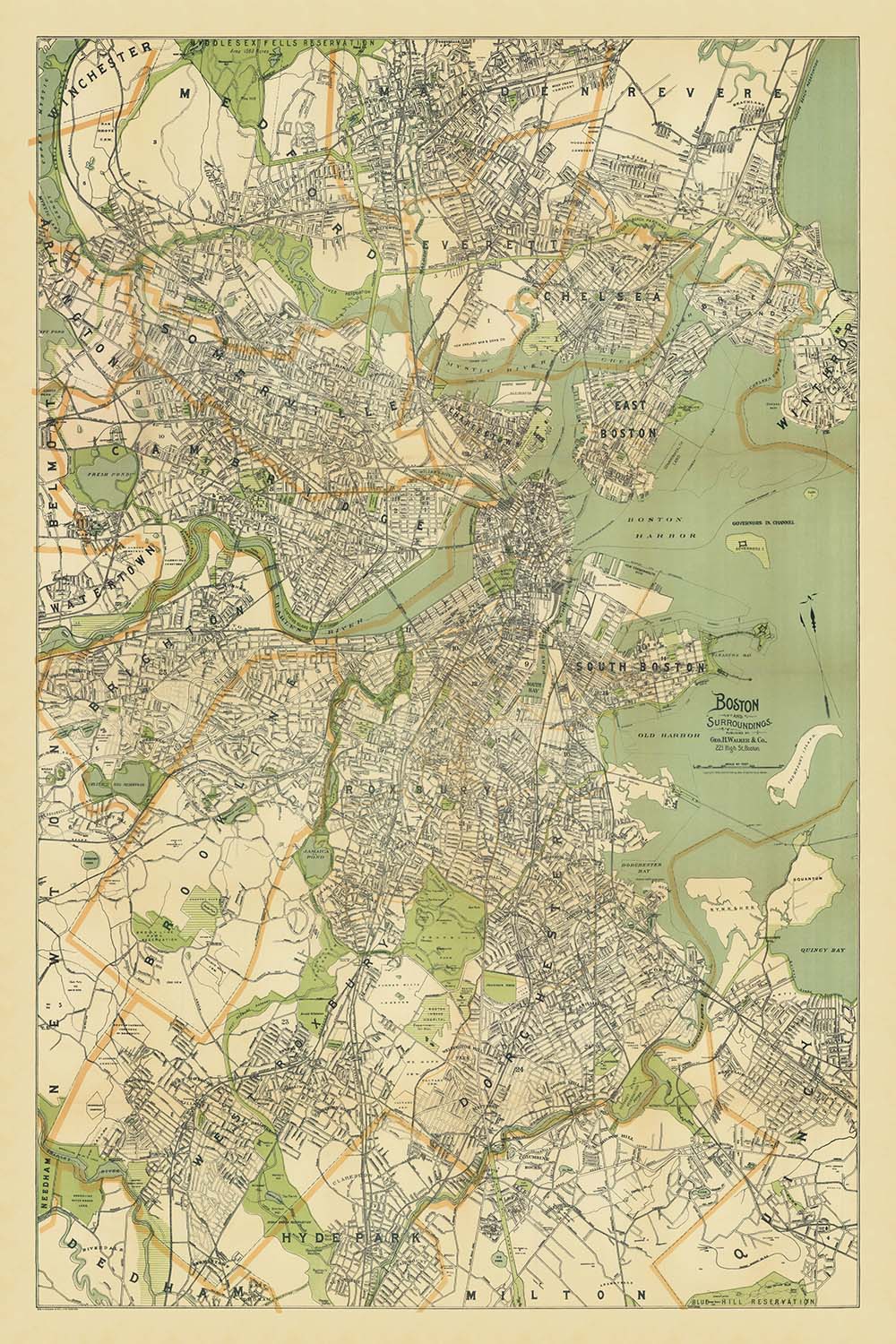
Adéntrese en el tapiz urbano de Boston a principios del siglo XX con "Boston y alrededores", un mapa de calles de la ciudad exquisitamente detallado publicado por la reconocida George H. Walker & Co. en 1905. Este mapa ofrece una visión rara e inmersiva de Boston en un momento de crecimiento y transformación dinámica, capturando no solo la intrincada cuadrícula de calles de la ciudad, sino también su relación con los municipios circundantes de Milton, Quincy, Dedham, Malden, Revere, Brighton y Watertown. La meticulosa cartografía del mapa es un testimonio del compromiso de Walker con la precisión y el arte, proporcionando tanto una guía práctica para los usuarios contemporáneos como un artefacto histórico para los coleccionistas modernos.
La cobertura del mapa es notable en su amplitud, abarcando el corazón de Boston y radiando hacia afuera para incluir los vibrantes vecindarios de la ciudad y importantes suburbios. Traza la evolución del núcleo urbano de Boston, desde las bulliciosas calles del Downtown y Back Bay hasta las extensas áreas arboladas de Jamaica Plain y las comunidades emergentes de Brighton y Watertown. Cada vecindario se representa con precisión, invitando a los espectadores a seguir el desarrollo de distritos icónicos y las conexiones entre ellos, una crónica visual de la expansión de Boston en los años anteriores a que el automóvil y el metro remodelaran su paisaje urbano.
Entre las características más cautivadoras del mapa se encuentran sus representaciones de los célebres parques y espacios públicos de Boston. El Boston Common y el Public Garden, ubicados en el centro de la ciudad, están claramente marcados, al igual que las extensiones verdes de Franklin Park y el Arnold Arboretum en el sur. Los Back Bay Fens y Jamaica Pond ofrecen más evidencia del compromiso de la ciudad con los espacios verdes, reflejando la influencia del sistema de parques Emerald Necklace de Frederick Law Olmsted. Estos hitos, junto con los serpenteantes ríos Charles y Mystic y el icónico puerto de Boston, proporcionan un rico contraste con la densa trama urbana de la ciudad y subrayan la importancia de la naturaleza en la identidad cívica de Boston.
Los hitos de aprendizaje y cultura también están destacados, incluyendo la Universidad de Harvard y el Instituto Tecnológico de Massachusetts en la vecina Cambridge. La Biblioteca Pública de Boston, un faro de conocimiento cerca de Copley Square, está claramente etiquetada, al igual que importantes cementerios como Mount Auburn. Estas instituciones, junto con las históricas arterias de la ciudad, como Beacon Street, Commonwealth Avenue, Tremont Street y Washington Street, por nombrar algunas, anclan el mapa en la vida intelectual y social de Boston a principios del siglo XX. La inclusión de ríos importantes, áreas del puerto y la red de transporte en evolución de la ciudad enriquece aún más la narrativa histórica capturada por este mapa.
George H. Walker & Co., el editor del mapa, fue celebrado por producir algunos de los mapas más precisos y estéticamente refinados de la época. Su experiencia es evidente en la claridad, detalle y arte de "Boston y alrededores." Este mapa se erige como un documento vital del pasado de Boston, ofreciendo a historiadores, coleccionistas y entusiastas una ventana inigualable a la geografía, infraestructura y vida diaria de la ciudad en un momento crucial de su historia. Ya sea exhibido como una pieza de declaración o estudiado por sus percepciones urbanas, este mapa es tanto una obra de arte como un portal al Boston de 1905.
Calles y carreteras en este mapa
- Calle Adams
- Calle Beacon
- Avenida Blue Hill
- Calle Boylston
- Broadway
- Calle Cambridge
- Calle Centre
- Calle Charles
- Avenida Columbus
- Avenida Commonwealth
- Avenida Concord
- Calle Court
- Calle Dartmouth
- Avenida Dorchester
- Calle Dudley
- Calle Essex
- Calle Hanover
- Calle Harvard
- Avenida Huntington
- Avenida Massachusetts
- Calle Milk
- Calle Morton
- Calle Mount Auburn
- Calle Newbury
- Calle School
- Avenida Shawmut
- Calle Summer
- Calle Tremont
- Calle Washington
- Avenida Western
Características y Monumentos Notables
- Boston Common (gran parque central)
- Jardín Público (adyacente a Boston Common)
- Parque Franklin (gran parque en el sur de Boston)
- Arnold Arboretum (espacio verde notable en Jamaica Plain)
- Río Charles (río principal que limita Boston y Cambridge)
- Río Mystic (río que marca el límite norte)
- Puerto de Boston (área costera y puerto)
- Back Bay Fens (zona verde en el área de Back Bay)
- Jamaica Pond (cuerpo de agua notable en Jamaica Plain)
- Blue Hills (borde sur, parcialmente visible)
- Universidad de Harvard (etiquetada en Cambridge)
- Instituto Tecnológico de Massachusetts (etiquetado en Cambridge)
- Biblioteca Pública de Boston (etiquetada cerca de Copley Square)
- South Bay (área de agua/puerto)
- Fenway Park (sitio etiquetado, aunque anterior al estadio actual)
- Cementerio Mount Auburn (etiquetado en el área de Cambridge/Watertown)
Contexto Histórico y de Diseño
- Creado en 1905 por George H. Walker & Co., un destacado editor de mapas con sede en Boston conocido por sus mapas detallados de ciudades y regiones a finales del siglo XIX y principios del XX.
- Muestra la ciudad de Boston en detalle, incluyendo áreas circundantes como partes de Milton, Quincy, Dedham, Malden, Revere, Brighton y Watertown.
- Principalmente un mapa de calles de la ciudad, centrado en el detalle a nivel de calle y la disposición urbana, destacando el desarrollo urbano y los límites municipales de Boston y sus suburbios inmediatos a principios del siglo XX.
- Se centra en Boston, Massachusetts, y municipios vecinos dentro del Condado de Suffolk y partes de los Condados de Norfolk y Middlesex.
- Típico de los mapas de ciudades de principios del siglo XX, con etiquetado claro, un enfoque en la legibilidad y cuadrículas de calles detalladas; en monocromo con líneas finas, característico del estilo de George H. Walker & Co.
- Proporciona una instantánea del paisaje urbano e infraestructura de Boston en 1905, justo antes de los importantes desarrollos del siglo XX, como la expansión del transporte público y el crecimiento de los suburbios.
- Útil para la investigación histórica, genealogía y estudios urbanos.
Por favor, verifica las imágenes para asegurarte de que se muestra una ciudad o lugar específico en este mapa. También puedes ponerte en contacto y pedirnos que verifiquemos el mapa por ti.
Este mapa se ve genial en cualquier tamaño, pero siempre recomiendo optar por un tamaño más grande si tienes espacio. De esa manera, puedes distinguir fácilmente todos los detalles.
Este mapa se ve increíble en tamaños de hasta 100in (250cm). Si buscas un mapa más grande, por favor ponte en contacto.
Por favor nota: las etiquetas en este mapa son difíciles de leer si pides un mapa que mida 36in (90cm) o menos. El mapa sigue siendo muy atractivo, pero si deseas leer el mapa fácilmente, por favor compra un tamaño más grande.
El modelo en las imágenes de la lista está sosteniendo la versión de 24x36in (60x90cm) de este mapa.
La quinta imagen de la lista muestra un ejemplo de mi servicio de personalización de mapas.
Si estás buscando algo ligeramente diferente, echa un vistazo a mi colección de los mejores mapas antiguos para ver si algo más llama tu atención.
Por favor, contáctame para verificar si una ubicación, monumento o característica específica se muestra en este mapa.
Este sería un regalo maravilloso para un cumpleaños, Navidad, Día del Padre, despedida del trabajo, aniversario o inauguración de casa para alguien de las áreas cubiertas por este mapa.
Este mapa está disponible como una impresión giclée en papel mate libre de ácido y de archivo, o puedes comprarlo enmarcado. El marco es un marco negro simple y agradable que se adapta a la mayoría de las estéticas. Por favor, ponte en contacto si deseas un color o material de marco diferente. Mis marcos están vidriados con acrílico de grado museo superclaro (perspex/acrylite), que es significativamente menos reflectante que el vidrio, más seguro y siempre llegará en perfectas condiciones.
This map is also available as a float framed canvas, sometimes known as a shadow gap framed canvas or canvas floater. The map is printed on artist's cotton canvas and then stretched over a handmade box frame. We then "float" the canvas inside a wooden frame, which is available in a range of colours (black, dark brown, oak, antique gold and white). This is a wonderful way to present a map without glazing in front. See some examples of float framed canvas maps and explore the differences between my different finishes.
For something truly unique, this map is also available in "Unique 3D", our trademarked process that dramatically transforms the map so that it has a wonderful sense of depth. We combine the original map with detailed topography and elevation data, so that mountains and the terrain really "pop". For more info and examples of 3D maps, check my Unique 3D page.
Para la mayoría de los pedidos, el tiempo de entrega es de aproximadamente 3 días laborables. Los productos personalizados y a medida tardan más, ya que tengo que hacer la personalización y enviártelo para su aprobación, lo cual suele tardar 1 o 2 días.
Tenga en cuenta que los pedidos enmarcados muy grandes suelen tardar más en fabricarse y entregarse.
Si necesitas que tu pedido llegue para una fecha determinada, por favor contáctame antes de hacer el pedido para que podamos encontrar la mejor manera de asegurarnos de que recibas tu pedido a tiempo.
Imprimo y enmarco mapas y obras de arte en 23 países alrededor del mundo. Esto significa que tu pedido se fabricará localmente, lo que reduce el tiempo de entrega y asegura que no se dañe durante el envío. Nunca pagarás aranceles de aduana o impuestos de importación, y pondremos menos CO2 en el aire.
Todos mis mapas y impresiones artísticas están bien empaquetados y enviados en un tubo resistente si no están enmarcados, o rodeados de espuma si están enmarcados.
Intento enviar todos los pedidos dentro de 1 o 2 días después de recibir tu pedido, aunque algunos productos (como mascarillas, tazas y bolsas de tela) pueden tardar más en fabricarse.
Si seleccionas Entrega Exprés al finalizar la compra, priorizaremos tu pedido y lo enviaremos por mensajería de 1 día (Fedex, DHL, UPS, Parcelforce).
La entrega al día siguiente también está disponible en algunos países (EE. UU., Reino Unido, Singapur, EAU), pero por favor intenta hacer tu pedido temprano en el día para que podamos enviarlo a tiempo.
Mi marco estándar es un marco de madera de fresno negro estilo galería. Es simple y tiene un aspecto bastante moderno. Mi marco estándar tiene alrededor de 20 mm (0.8 in) de ancho.
Utilizo acrílico super claro (perspex/acrylite) para el vidrio del marco. Es más ligero y seguro que el vidrio, y se ve mejor, ya que la reflectividad es menor.
Seis colores de marco estándar están disponibles de forma gratuita (negro, marrón oscuro, gris oscuro, roble, blanco y oro antiguo).El enmarcado y montaje/matizado personalizado está disponible si buscas algo diferente.
La mayoría de los mapas, arte e ilustraciones también están disponibles como un lienzo enmarcado. Utilizamos lienzo de algodón mate (no brillante), lo estiramos sobre un marco de madera de caja de origen sostenible, y luego 'flotamos' la pieza dentro de un marco de madera. El resultado final es bastante hermoso, y no hay cristal que se interponga.
Todos los marcos se proporcionan "listos para colgar", con una cuerda o soportes en la parte posterior. Los marcos muy grandes tendrán placas de colgar de alta resistencia y/o un listón de montaje. Si tienes alguna pregunta, por favor ponte en contacto.
Mira algunos ejemplos de mis mapas enmarcados y mapas en lienzo enmarcados.
Alternativamente, también puedo proporcionar mapas antiguos y obras de arte en lienzo, tablero de espuma, papel de algodón y otros materiales.
Si deseas enmarcar tu mapa o obra de arte tú mismo, por favor lee mi guía de tamaños primero.
Algunos de mis mapas antiguos ahora están disponibles como lienzos enmarcados. Por favor contáctame si deseas pedir un tamaño que no está disponible en mi tienda.
Los mapas antiguos en lienzo son una alternativa interesante a los mapas enmarcados convencionalmente. Dependiendo de tu gusto personal y la decoración de la habitación, los mapas en lienzo pueden "destacar" un poco más que un mapa enmarcado.
Mis mapas son reproducciones de mapas originales de altísima calidad.
Obtengo mapas originales y raros de bibliotecas, casas de subastas y colecciones privadas de todo el mundo, los restauro en mi taller de Londres y luego uso tintas e impresoras giclée especializadas para crear hermosos mapas que lucen incluso mejor que el original.
Mis mapas están impresos en papel de archivo mate (no brillante) sin ácido que se siente de muy alta calidad y casi como una tarjeta. En términos técnicos, el peso/grosor del papel es de 10 mil/200 g/m². Es perfecto para enmarcar.
Imprimo con tintas pigmentadas Epson ultrachrome giclée UV resistentes a la decoloración, algunas de las mejores tintas que puedes encontrar.
yo también puedo hacer mapas sobre lienzo, trapo de algodón y otros materiales exóticos.
Obtenga más información sobre The Unique Maps Co..
Personalización de mapas
Si está buscando el regalo perfecto de aniversario o inauguración de la casa, puedo personalizar su mapa para hacerlo verdaderamente único. Por ejemplo, puedo agregar un mensaje corto, resaltar una ubicación importante o agregar el escudo de armas de su familia.
Las opciones son casi infinitas. Por favor mira mi página de personalización de mapas para ver algunos maravillosos ejemplos de lo que es posible.
Para pedir un mapa personalizado, seleccione "personalizar su mapa" antes de agregarlo a su carrito.
Ponerse en contacto si buscas personalizaciones y personalizaciones más complejas.
Envejecimiento del mapa
A lo largo de los años, los clientes me han preguntado cientos de veces si podían comprar un mapa que se viera uniforme. más viejo.
Bueno, ahora puedes hacerlo seleccionando Envejecido antes de agregar un mapa a tu carrito.
Todas las fotografías de productos que ve en esta página muestran el mapa en su forma original. Así es como se ve el mapa hoy.
Si selecciona Envejecido, envejeceré su mapa a mano, usando un proceso especial y único desarrollado a través de años de estudiar mapas antiguos, hablar con investigadores para comprender la química del envejecimiento del papel y, por supuesto... ¡mucha práctica!
Si no estás seguro, quédate con el color original del mapa. Si quieres algo un poco más oscuro y más viejo buscando, opte por Envejecido.
Si no estás satisfecho con tu pedido por cualquier motivo, contáctame para un reembolso sin complicaciones. Por favor, consulta nuestra política de devoluciones y reembolsos para más información.
Estoy muy seguro de que te gustará tu mapa o impresión artística restaurada. He estado haciendo esto desde 1984. Soy un vendedor de 5 estrellas en Etsy. He vendido decenas de miles de mapas e impresiones artísticas y tengo más de 5,000 opiniones reales de 5 estrellas.
Utilizo un proceso único para restaurar mapas y obras de arte que consume mucho tiempo y mano de obra. Buscar los mapas e ilustraciones originales puede llevar meses. Utilizo tecnología de última generación y extremadamente cara para escanear y restaurarlos. Como resultado, garantizo que mis mapas e impresiones artísticas son superiores a los demás - por eso puedo ofrecer un reembolso sin complicaciones.
Casi todos mis mapas e impresiones artísticas se ven increíbles en tamaños grandes (200cm, 6.5ft+) y también puedo enmarcarlos y entregártelos a través de un servicio de mensajería especial para tamaños grandes. Contáctame para discutir tus necesidades específicas.
Or try searching for something!


