


Old City Map of Fort Myers Florida by Frank B. Dolph, 1945: Caloosahatchee, City Hall, Yacht Basin, Courthouse, Golf Course
The price will update when you pick
different sizes and framing below


-
FREE delivery in 2 to 3 days
Free delivery in 2 to 3 days
Your map should be delivered in 2 to 3 working days with free delivery, worldwide.
Father's Day orders: Please use Next Day delivery at checkout. Free delivery is unlikely to arrive on time.
We make maps by hand locally in 23 countries, including the UK
![]() . If you're buying a gift for someone in another country, we will make the map locally to them.
. If you're buying a gift for someone in another country, we will make the map locally to them.You will never pay import tax or customs duty.
Express delivery is available at checkout which can reduce the delivery time to 1-2 days.
Please note that personalised maps, and larger framed maps, can take longer to produce and deliver.
If you need your order to arrive by a certain date, contact me and we can discuss your options.
-
Certified sustainable +
we plant trees🌳
Sustainability & Tree Planting
Here at The Unique Maps Co., we have an unusually high affinity for paper. After all, without paper, there can be no maps!
That's why all of our paper, frames and packaging are from FSC certified sources.
But we don't stop there. We've partnered with Treeapp to plant trees around the world.
If you spend £50 or more, we'll plant a tree in your name.
We also cover the costs of offsetting the carbon emissions on all deliveries.
- Framing & free personalisation available
-
90 day money back guarantee
90 days to return and refund
Products can be returned within 90 days for a full refund, or exchange for another product.
For personalised or custom made items, we may offer you a non-expiring gift card, as we cannot resell personalised orders.
If you have any questions, get in touch. For more information, see our full returns & exchanges policy.
- Shop local! We're based in London
My maps are rare, museum-grade, restored old maps sourced from libraries, auction houses and private collections across the globe.
Gift message & custom finish

If you want to add a gift message, or a finish (jigsaw, aluminium board, etc.) that is not available here, please request it in the "order note" when you check out.
Every order is custom made, so if you need the size adjusted slightly, or printed on an unusual material, just let us know. We've done thousands of custom orders over the years, so there's (almost) nothing we can't manage.
You can also contact us before you order, if you prefer!
- FREE 2-3 day worldwide delivery
- 90 day money back guarantee
- Handmade, museum-grade quality
- Bank grade payment security

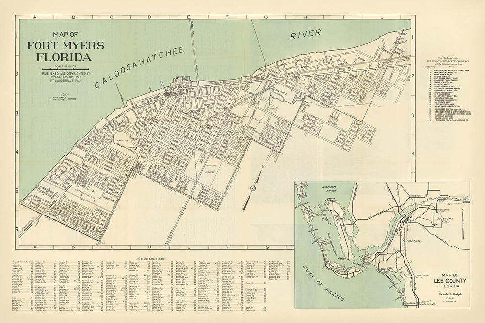
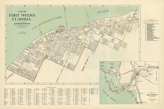
The "Map of Fort Myers Florida," crafted in 1945 by the esteemed Frank B. Dolph, offers a captivating window into the city’s postwar landscape. Issued by the Lee County Chamber of Commerce, this city street map captures Fort Myers at a transformative moment, just as it was emerging from its small-town roots into a vibrant Florida destination. With the Caloosahatchee River elegantly bordering the city, Dolph’s map showcases the vital arteries and civic heart of Fort Myers, providing a rare, detailed glimpse into its mid-20th-century layout.
Frank B. Dolph, a renowned mid-century mapmaker based in Fort Lauderdale, brought a meticulous eye and regional expertise to his cartographic work. His maps are celebrated for their clarity, precision, and historical value, and this Fort Myers edition is no exception. Dolph’s attention to detail is evident in the careful labelling of key landmarks—such as the City Hall, Lee County Courthouse, and the bustling Yacht Basin—each one a testament to the city’s growing civic pride and community spirit during the 1940s.
This map is particularly notable for its inclusion of significant public spaces and recreational sites that defined the city’s social life. The Fair Grounds, Ball Park, and the Golf Course are all prominently marked, reflecting Fort Myers’ burgeoning reputation as a destination for leisure and sport. The presence of the Hospital, High School, and Post Office further underscores the city’s expanding infrastructure and its commitment to serving a growing population.
Dolph’s design also highlights the intricate network of streets and boulevards that shaped daily life in Fort Myers. Thoroughfares such as McGregor Boulevard, First Street, and Royal Palm Avenue are meticulously plotted, offering a fascinating record of the city’s urban planning and transportation routes in the 1940s. The map’s clarity and depth make it an invaluable resource for anyone interested in the evolution of American cities, especially those drawn to the unique charm of historic Florida.
Adding to its historical richness, the map features an inset of Lee County, encompassing the surrounding islands of Sanibel, Captiva, and Pine Island, as well as Bonita Springs. This regional perspective situates Fort Myers within the broader context of southwest Florida’s coastal communities, making the map not only a city guide but also a portal to the wider landscape that has long attracted visitors and residents alike. Collectors and history enthusiasts will find in Dolph’s 1945 map a masterful blend of artistry, local heritage, and cartographic excellence.
Streets and roads on this map
- Anderson Avenue
- Bay Street
- Broadway
- Broward Avenue
- Carson Street
- Central Avenue
- Cleveland Avenue
- Cranford Avenue
- Dean Street
- Evans Avenue
- Fowler Street
- First Street
- Ford Street
- Grand Avenue
- Hanson Street
- Heitman Street
- Jackson Street
- Lee Street
- Lincoln Boulevard
- Main Street
- McGregor Boulevard
- Michigan Avenue
- Monroe Street
- Palm Avenue
- Park Avenue
- Royal Palm Avenue
- Second Street
- Victoria Avenue
- Washington Avenue
- Widman Way
Notable Features & Landmarks
- Inset plan of Lee County, including Sanibel Island, Captiva Island, Pine Island, Bonita Springs, and other regional features
- Caloosahatchee River (major river bordering the city)
- City Hall
- Yacht Basin
- Post Office
- High School
- Lee County Courthouse
- Hospital
- Country Club
- Fair Grounds
- Ball Park
- Golf Course
- Railroad lines (labelled)
- Bridges crossing the Caloosahatchee River
Historical and design context
- Crafted in 1945, capturing Fort Myers during a period of rapid growth and urban development
- Created by Frank B. Dolph, a notable mid-20th-century Florida mapmaker known for detailed and accurate city and regional maps
- Issued by the Lee County Chamber of Commerce
- Provides a detailed street layout and key locations in Fort Myers as of the mid-1940s
- Includes an inset map for broader regional context, situating Fort Myers within Lee County and its surrounding islands
- Reflects the city’s evolution from a small town to a growing urban center, with a population just over 9,000 by 1930
- Designed with clarity and utility, typical of mid-20th-century city maps
- Offers a valuable historical snapshot of Fort Myers’ infrastructure, public spaces, and civic landmarks just after World War II
Please double check the images to make sure that a specific town or place is shown on this map. You can also get in touch and ask us to check the map for you.
This map looks great at every size, but I always recommend going for a larger size if you have space. That way you can easily make out all of the details.
This map looks amazing at sizes all the way up to 100in (250cm). If you are looking for a larger map, please get in touch.
Please note: the labels on this map are hard to read if you order a map that is 16in (40cm) or smaller. The map is still very attractive, but if you would like to read the map easily, please buy a larger size.
The model in the listing images is holding the 24x36in (60x90cm) version of this map.
The fifth listing image shows an example of my map personalisation service.
If you’re looking for something slightly different, check out my collection of the best old maps to see if something else catches your eye.
Please contact me to check if a certain location, landmark or feature is shown on this map.
This would make a wonderful birthday, Christmas, Father's Day, work leaving, anniversary or housewarming gift for someone from the areas covered by this map.
This map is available as a giclée print on acid free archival matte paper, or you can buy it framed. The frame is a nice, simple black frame that suits most aesthetics. Please get in touch if you'd like a different frame colour or material. My frames are glazed with super-clear museum-grade acrylic (perspex/acrylite), which is significantly less reflective than glass, safer, and will always arrive in perfect condition.
This map is also available as a float framed canvas, sometimes known as a shadow gap framed canvas or canvas floater. The map is printed on artist's cotton canvas and then stretched over a handmade box frame. We then "float" the canvas inside a wooden frame, which is available in a range of colours (black, dark brown, oak, antique gold and white). This is a wonderful way to present a map without glazing in front. See some examples of float framed canvas maps and explore the differences between my different finishes.
For something truly unique, this map is also available in "Unique 3D", our trademarked process that dramatically transforms the map so that it has a wonderful sense of depth. We combine the original map with detailed topography and elevation data, so that mountains and the terrain really "pop". For more info and examples of 3D maps, check my Unique 3D page.
For most orders, delivery time is about 3 working days. Personalised and customised products take longer, as I have to do the personalisation and send it to you for approval, which usually takes 1 or 2 days.
Please note that very large framed orders usually take longer to make and deliver.
If you need your order to arrive by a certain date, please contact me before you order so that we can find the best way of making sure you get your order in time.
I print and frame maps and artwork in 23 countries around the world. This means your order will be made locally, which cuts down on delivery time and ensures that it won't be damaged during delivery. You'll never pay customs or import duty, and we'll put less CO2 into the air.
All of my maps and art prints are well packaged and sent in a rugged tube if unframed, or surrounded by foam if framed.
I try to send out all orders within 1 or 2 days of receiving your order, though some products (like face masks, mugs and tote bags) can take longer to make.
If you select Express Delivery at checkout your order we will prioritise your order and send it out by 1-day courier (Fedex, DHL, UPS, Parcelforce).
Next Day delivery is also available in some countries (US, UK, Singapore, UAE) but please try to order early in the day so that we can get it sent out on time.
My standard frame is a gallery style black ash hardwood frame. It is simple and quite modern looking. My standard frame is around 20mm (0.8in) wide.
I use super-clear acrylic (perspex/acrylite) for the frame glass. It's lighter and safer than glass - and it looks better, as the reflectivity is lower.
Six standard frame colours are available for free (black, dark brown, dark grey, oak, white and antique gold). Custom framing and mounting/matting is available if you're looking for something else.
Most maps, art and illustrations are also available as a framed canvas. We use matte (not shiny) cotton canvas, stretch it over a sustainably sourced box wood frame, and then 'float' the piece within a wood frame. The end result is quite beautiful, and there's no glazing to get in the way.
All frames are provided "ready to hang", with either a string or brackets on the back. Very large frames will have heavy duty hanging plates and/or a mounting baton. If you have any questions, please get in touch.
See some examples of my framed maps and framed canvas maps.
Alternatively, I can also supply old maps and artwork on canvas, foam board, cotton rag and other materials.
If you want to frame your map or artwork yourself, please read my size guide first.
My maps are extremely high quality reproductions of original maps.
I source original, rare maps from libraries, auction houses and private collections around the world, restore them at my London workshop, and then use specialist giclée inks and printers to create beautiful maps that look even better than the original.
My maps are printed on acid-free archival matte (not glossy) paper that feels very high quality and almost like card. In technical terms the paper weight/thickness is 10mil/200gsm. It's perfect for framing.
I print with Epson ultrachrome giclée UV fade resistant pigment inks - some of the best inks you can find.
I can also make maps on canvas, cotton rag and other exotic materials.
Learn more about The Unique Maps Co.
Map personalisation
If you're looking for the perfect anniversary or housewarming gift, I can personalise your map to make it truly unique. For example, I can add a short message, or highlight an important location, or add your family's coat of arms.
The options are almost infinite. Please see my map personalisation page for some wonderful examples of what's possible.
To order a personalised map, select "personalise your map" before adding it to your basket.
Get in touch if you're looking for more complex customisations and personalisations.
Map ageing
I have been asked hundreds of times over the years by customers if they could buy a map that looks even older.
Well, now you can, by selecting Aged before you add a map to your basket.
All the product photos you see on this page show the map in its Original form. This is what the map looks like today.
If you select Aged, I will age your map by hand, using a special and unique process developed through years of studying old maps, talking to researchers to understand the chemistry of aging paper, and of course... lots of practice!
If you're unsure, stick to the Original colour of the map. If you want something a bit darker and older looking, go for Aged.
If you are not happy with your order for any reason, contact me for a no-quibble refund.
I am very confident you will like your restored map or art print. I have been doing this since 1984. I'm a 5-star Etsy seller. I have sold tens of thousands of maps and art prints and have over 4,000 real 5-star reviews.
I use a unique process to restore maps and artwork that is massively time consuming and labour intensive. Hunting down the original maps and illustrations can take months. I use state of the art and eye-wateringly expensive technology to scan and restore them. As a result, I guarantee my maps and art prints are a cut above the rest - that's why I can offer a no-quibble refund.
Almost all of my maps and art prints look amazing at large sizes (200cm, 6.5ft+) and I can frame and deliver them to you as well, via special oversized courier. Contact me to discuss your specific needs.


Or try searching for something!


